- Moorby
-
Coordinates: 53°09′27″N 0°04′07″W / 53.15749°N 0.06856°W
Moorby 
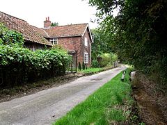
The brook at Moorby
 Moorby shown within Lincolnshire
Population 50 OS grid reference TF292640 District East Lindsey Shire county Lincolnshire Region East Midlands Country England Sovereign state United Kingdom Post town BOSTON Postcode district PE22 Dialling code 01507 Police Lincolnshire Fire Lincolnshire Ambulance East Midlands EU Parliament East Midlands List of places: UK • England • Lincolnshire Moorby is a small village in East Lindsey, in the county of Lincolnshire, England with around fifty inhabitants. It is close to Wood Enderby. The village is in the parish of Claxby with Moorby, where Claxby refers to Claxby Pluckacre.
There are about twelve houses, including the Old Rectory, the Old School House, the Royal Oak (no longer a licensed premises), amongst others.[citation needed]
The church (dedicated to All Saints) was demolished in the 1980s[1] due to high maintenance costs, although the graveyard remains and the carved stonework can still be found in many gardens in the village.[citation needed] The Shell Guide to Lincolnshire describes Moorby church as being "much restored by James Fowler in 1866, but he left a large and very early font".[2]
The Methodist chapel still stands but is now outhouses for a private residence. The village is also home to Oslinc, a farm where ostriches are reared for meat, eggs, and feathers.
Most local gatherings in the village take place in the village hall, a Rural Education Centre on Cooks Farm (including village council meetings and the annual Harvest Supper, which residents of Wilksby also attend) or on the village green, a small grassy area on the site of an old farmyard, probably owned by the nearby Scrivelsby estate.[citation needed] Church services are held in Wilksby church (built by the Stanhope family at a cost of £99) every third Sunday in the month.[citation needed]
Until recently, the village was also home to Camp 79,[3] one of only five remaining POW camps in England, according to English Heritage. The camp's huts were used for many years as turkey sheds,[4] but were knocked down and the rubble sold off after an illegal rave was held in the deteriorating buildings.[citation needed] The subject of the rave is still a controversial one in the village, with dissatisfaction over police handling of the case: officers said that said "ravers could not be evicted because there were fewer than 100 trouble-makers involved". The camp was a standard WWII working camp and housed a large number of German soldiers, many of whom integrated into the local population; many have fond memories of their time in the village and still visit the area.[citation needed]
According to an RAF website, Moorby was 'a Great War landing ground', but the meaning of this statement is still unknown.[citation needed]
The village name means the fen village or farm, from ON mór a fen, a moor and bý a farmstead, a village, Morebi appears in Domesday Book of 1086 and the Lord of the Manor was King William I.[5] The village seems to have been excluded from the 1901 census.[citation needed]
The village did have its own 'magic stone', although it has disappeared some time in the last few years and is reported to have been moved to a nearby farmyard. It was said that it enabled one to see the devil under the correct circumstances.[citation needed]
References
- ^ "Pastscape". All Saints Church, Moorby. English Heritage. http://www.pastscape.org.uk/hob.aspx?hob_id=527270&sort=4&search=all&criteria=Moorby&rational=q&recordsperpage=60. Retrieved 3 June 2011.
- ^ Henry Thorold; Jack Yates (1965). A Shell Guide to Lincolnshire. Faber and Faber, London. p. 105.
- ^ "POW Camps in the UK". Moorby - Camp 79. Malcolm Sanders. http://www.kg6gb.org/pow_camps_in_uk_51_to_100.htm. Retrieved 3 June 2011.
- ^ "Pastscape". POW Camp Moorby. English Heritage. http://www.pastscape.org.uk/hob.aspx?hob_id=1434353&sort=4&search=all&criteria=Moorby&rational=q&recordsperpage=60. Retrieved 3 June 2011.
- ^ "Domesday Map". Moorby. Anna Powell-Smith. http://www.domesdaymap.co.uk/place/TF2964/Moorby/. Retrieved 3 June 2011.
External links
Categories:- Villages in Lincolnshire
- East Lindsey
- Lincolnshire geography stubs
Wikimedia Foundation. 2010.

