- Dunolly, Victoria
-
Dunolly
Victoria
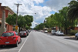
Broadway, the main street of DunollyPopulation: 969(2006)[1] Postcode: 3472 Location: - 188 km (117 mi) NW of Melbourne
- 61 km (38 mi) W of Bendigo
- 23 km (14 mi) N of Maryborough
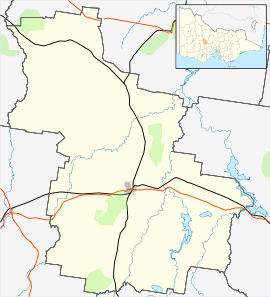
LGA: Shire of Central Goldfields State District: Ripon Federal Division: Bendigo Dunolly is a town in Victoria, Australia, located on the Dunolly - Maryborough Road, in the Shire of Central Goldfields. At the 2006 census, Dunolly had a population of 969.
The town began during the Victorian Gold Rush, and has produced more nuggets than any other goldfield in Australia. The town was first known as Goldborough and the Post Office opened under that name on 1 March 1856 and was renamed Dunolly in 1859.[2]
The legendary "Welcome Stranger", one of the largest natural gold nuggets ever, was discovered in nearby Moliagul.
Centered around the main street "Broadway" Dunolly features both a top and bottom pub, hospital, grain terminal and a primary school.
Although located on a major rail line no passenger services are available.
There is a local museum on "Broadway". It has a major collection of historic photographs and goldfields implements.
Dunolly has become a favorite location for gold fossicking using metal detectors. A number of small scale alluvial mining operations work local "leads" using mechanical diggers.
The town boasts two cafes and two pubs, a bakery/cafe, a butcher, a small IGA type supermarket, a hardware & produce supplier, an agricultural machinery oriented service station and fuel stop, a Bed and breakfast ("Footer's Mansion"), a motel, historic buildings and well marked cycle tracks through the abandoned diggings.
The town's Australian Rules football team, The Dunolly Eagles, competes in the Maryborough Castlemaine District Football League. Star recruits Shannon Motlop and Robbie Ahmat play in the team.[3]
Golfers play at the Dunolly Golf Club on Separation Street.[4]
References
- ^ Australian Bureau of Statistics (25 October 2007). "Dunolly (State Suburb)". 2006 Census QuickStats. http://www.censusdata.abs.gov.au/ABSNavigation/prenav/LocationSearch?collection=Census&period=2006&areacode=SSC25523&producttype=QuickStats&breadcrumb=PL&action=401. Retrieved 2007-10-01.
- ^ Premier Postal History, Post Office List, https://www.premierpostal.com/cgi-bin/wsProd.sh/Viewpocdwrapper.p?SortBy=VIC&country=, retrieved 2008-04-11
- ^ Full Points Footy, Dunolly, http://www.fullpointsfooty.net/dunolly.htm, retrieved 2009-04-15
- ^ Golf Select, Dunolly, http://www.golfselect.com.au/armchair/courseView.aspx?course_id=966, retrieved 2009-05-11
External links
- Dunnoly Gold Field Victoria Geol. Survey 1904, WM Bradford. Description of Gold area
Gallery
Coordinates: 36°51′S 143°44′E / 36.85°S 143.733°E
Towns in the Shire of Central Goldfields Adelaide Lead • Alma • Amherst • Bealiba • Bung Bong • Carisbrook • Dunolly • Flagstaff • Majorca • Maryborough • Moliagul • Talbot • Timor
Categories:- Towns in Victoria (Australia)
- Mining towns in Victoria (Australia)
Wikimedia Foundation. 2010.


