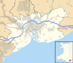
- Malpas, Newport
-
Coordinates: 51°36′42″N 3°00′18″W / 51.61172°N 3.00509°W
Malpas
 Malpas shown within Newport
Population 8,148 (2001 census) OS grid reference ST305908 Principal area Newport Country Wales Sovereign state United Kingdom Post town NEWPORT Postcode district NP20 6 Dialling code +44-1633
Chartist exchangePolice Gwent Fire South Wales Ambulance Welsh EU Parliament Wales UK Parliament Newport West List of places: UK • Wales • Newport Malpas is an electoral district (ward) and coterminous community parish of the city of Newport, South Wales. The area is governed by the Newport City Council.
Contents
Boundaries
The ward is bounded by the A4042 Heidenheim Drive to the east, the city boundary to the north, Malpas brook to the west, and Bettws Lane, Llanover Close, and the western and northern edges of Graig Wood, Yewberry Lane and Grove Park Drive to the south.
Name origin
The name is French and comes from Mal (bad/poor) and Pas (passage/way). Earlier examples of the name include the definite article 'Le' and even an odd Welsh definite article 'Y' i.e. Le Malpas, Y Malpas.
The community
There are two large housing estates either side of the main Malpas Road (A4051): Hollybush and Malpas Court to the west is a council estate (although many of the houses are now in private ownership) and to the east are Malpas Park, Claremont, Pilton Vale and the Woodlands all of which is privately-owned. The roads in Malpas Court take their names from famous inventors and scientists, while those in Malpas Park are named after trees. The roads in Woodlands are named after World War II generals, e.g. Allenbrooke Avenue, Horrocks Close, Montgomery Road, Robertson Way, Wavell Drive, etc. Claremont and Pilton Vale however are just single street names with large house numbers.
History
The Malpas Institute Trust is a charitable fund, founded on the sale of the World War I Memorial Institute.[1]
Schooling
There are four primary schools in the ward. Malpas Church Infants[2], Malpas Church Juniors[3], Malpas Court[4], and Malpas Park[5].
Churches
There are three Christian churches in Malpas, St. Mary's Church in Wales, Trinity Presbyterian, and St. Anne's Roman Catholic. The fourth Malpas Church, Christchurch[6], which is just off the Old Malpas Road is in the Shaftesbury Ward. There are no formal places of worship for other religions or faiths.
Private hospital & Fire services
Malpas is also home to the only private hospital in Newport, St. Joseph's Hospital[7], run by the Sisters of St Joseph of Annecy[8], and an in-patient hospice service, St Anne's Hospice[9], run by the same group.
A station of South Wales Fire and Rescue Service is located in Malpas.
Army Cadet Force
There is a detachment for Gwent & Powys ACF[10] near Oliphant Circle. It is badged to the local TA regiment the Royal Monmouthshire Royal Engineers. The detachment parades on Thursday 1830 - 2030 and welcomes 12 - 18yr olds. For more infomration on the Army Cadet Force.
Cycling and Walking
A cycle and pedestrian walkway alongside the River Usk links Malpas to Caerleon and Newport city centre at Crindau[11].
References
- ^ index.htm
- ^ Malpas Church Infant School
- ^ Malpas Church Junior School
- ^ http://www.newportsouthwales.net/malpascourt/
- ^ Malpas Park Primary School Home Page
- ^ / ChristchurchNet.org /
- ^ St. Joseph's Hospital, Newport, South Wales
- ^ http://web.archive.org/web/20091027052250/http://geocities.com/ssjannecy1/
- ^ Home Page
- ^ Army Cadet Force Gwent & Powys - Home
- ^ Caerleon cycle path extension
External links
- http://www.themalpasthree.org.uk/ local councillors' website
Categories:- Newport geography stubs
- Districts of Newport
- Wards of Newport
- M4 corridor
Wikimedia Foundation. 2010.

