- Coedkernew
-
Coordinates: 51°33′01″N 3°02′23″W / 51.55028°N 3.03979°W
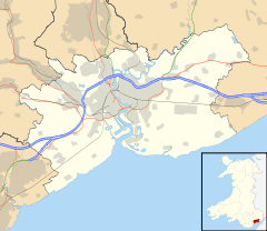
Coedkernew
 Coedkernew shown within Newport
Population 573 (2001 census[1]) OS grid reference ST280840 Principal area Newport Country Wales Sovereign state United Kingdom Post town NEWPORT Dialling code +44-1633
Maesglas and Castleton exchangesPolice Gwent Fire South Wales Ambulance Welsh EU Parliament Wales UK Parliament Newport West List of places: UK • Wales • Newport Coedkernew (Welsh: Coedcernyw) is a community in the south west of the city of Newport, South Wales, in the Marshfield ward.
The parish is bounded by Percoed reen to the south, Nant-y-Selsig to the southwest, and Pound Hill to the west. The northern boundary is formed from Gwern-y-cleppa to junction 28 of the M4, then the A48 Cardiff Road. The eastern boundary is formed from the Ebbw River Bridge roundabout to the west of the International Rectifier plant, Duffryn Drive, along the southern edge of Tredegar House country park, Pencarn Lane and Percoed Lane.
Despite being a mostly rural parish to the south and west, the north and east is a continuation of the Duffryn built-up area, and has seen large increases in population in recent years due to the continued suburbanisation of Newport. This built-up area of Coedkernew forms a 'c-shape' around Duffryn and as such, much newly-built housing in the Duffryn area actually falls within Coedkernew.
This area contains the Coedkernew footbridge over the A48,[2] the giant LG plant, three business parks or industrial parks: Imperial Park,[3] Celtic Springs[4] and Cleppa Park, the Patent Office, Office for National Statistics, Tredegar House as well as the large Celtic Horizons estate and St. Josephs RC High School.
At the northern boundary near Gwern-y-cleppa, the remains of a pre-historic burial chamber can be found which is believed to be neolithic.[5]
Government
The area is governed by the Newport City Council and the Coedkernew community council.
References
- ^ Office for National Statistics Parish Headcounts: Coedkernew
- ^ Coedkernew Footbridge:: OS grid ST2784 :: Geograph Britain and Ireland - photograph every grid square!
- ^ Imperial Park, Newport:: OS grid ST2884 :: Geograph Britain and Ireland - photograph every grid square!
- ^ Celtic Springs Business Park, Newport:: OS grid ST2784 :: Geograph Britain and Ireland - photograph every grid square!
- ^ GWERN-Y-CLEPPA, LONG BARROW | Site Details | Coflein
External links
Categories:- Districts of Newport
- Newport geography stubs
Wikimedia Foundation. 2010.

