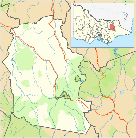
- Dinner Plain, Victoria
-
Dinner Plain
Victoria
Dinner PlainPopulation: 88(2006)[1] Postcode: 3898 Coordinates: 37°01′48″S 147°16′44″E / 37.03°S 147.279°ECoordinates: 37°01′48″S 147°16′44″E / 37.03°S 147.279°E Elevation: 1,570 m (5,151 ft) Location: - 389 km (242 mi) NW of Melbourne
- 143 km (89 mi) SE of Wangaratta
- 45 km (28 mi) W of Omeo
LGA: Alpine Shire State District: Benalla Federal Division: Indi Mean max temp Mean min temp Annual rainfall 9.7 °C
49 °F2.7 °C
37 °F1,207.7 mm
47.5 inDinner Plain is a town[2] in Victoria, Australia, located on the Great Alpine Road, 10 kilometres from Mount Hotham Alpine Resort, and 375 kilometres from Melbourne. At the 2006 census, Dinner Plain had a population of 88, yet has over 200 lodges and chalets for tourist accommodation. It is the only freehold village in the Australian Alps.[citation needed]
Dinner Plain is now a thriving all year round resort with a wide range of summer activities such as bush walking, horse riding, mountain biking and tennis. The local pub is open for lunch and dinner 7 days a week and a new spa and beauty centre has recently opened.[citation needed]
Dinner Plain has one small supermarket, Brandy Creek, which is open for business 364 days of the year.
Dinner Plain has one ski tow for use in winter.
History..
The traditional Aboriginal owners of the Dinner Plain region are the Gunai - Kurnai people. http://www.atns.net.au/agreement.asp?EntityID=5037 Aboriginal people lived in, and passed through, the Alpine area of Victoria's High Country for many thousands of years.
The tradition of hospitality at Dinner Plain goes back well over a century, when mountain cattlemen first arrived in this beautiful stretch of countryside as an ideal place to relax, gobble up a meal and graze their cattle. The site of Dinner Plain village was originally part of 640 acres (2.6 km2) . When the coaches were running between Omeo and Bright, they would stop here for midday dinner, hence the area became known as Dinner Plain.
References
- ^ Australian Bureau of Statistics (25 October 2007). "Dinner Plain (State Suburb)". 2006 Census QuickStats. http://www.censusdata.abs.gov.au/ABSNavigation/prenav/LocationSearch?collection=Census&period=2006&areacode=SSC25487&producttype=QuickStats&breadcrumb=PL&action=401. Retrieved 2007-10-01.
- ^ "Dinner Plain map". ©2009 Google - Map data©2009 MapData Sciences Pty Ltd. http://maps.google.com.au/maps?f=q&source=s_q&hl=en&geocode=&q=dinner+plain&sll=-25.335448,135.745076&sspn=47.887006,67.851563&ie=UTF8&ll=-37.023944,147.239048&spn=0.020352,0.049438&z=15&iwloc=addr. Retrieved 10/02/2009.
External links
Towns in Alpine Shire Barwidgee · Bright · Dederang · Dinner Plain · Eurobin · Harrietville · Kancoona · Mount Beauty · Myrtleford · Ovens · Porepunkah · Rosewhite · Tawonga · Tawonga South · Wandiligong

This article about a location in Gippsland is a stub. You can help Wikipedia by expanding it.


