- Philmont Scout Ranch camps
-
"Clark's Fork" redirects here. For the location in Wyoming, see Clarks Fork Yellowstone River. For other uses, see Clark Fork (disambiguation).
Philmont Scout Ranch 
Owner Boy Scouts of America Location Cimarron, New Mexico Country United States Founded 1938 Founder Waite Phillips The following are the camps located in Philmont Scout Ranch, a large property in Colfax County near Cimarron, New Mexico, owned by the Boy Scouts of America and used as a backpacking reservation.
As of 2005, there were 57 trail camps and 34 staffed camps, as well as Base Camp.
Trail camps
- Agua Fria
- Location: South Country
- Aguila
- Location: South Country
- Anasazi
- This camp is a small, unstaffed camp located near an untreated water source, and is often used as one of the starting camps for many treks. Location: North Country
- Aspen Springs
- Elevation: 7,900 feet (2,407.9 m); location: Central Country, 36°30′11″N 105°03′34″W / 36.50306°N 105.05944°W
- Bear Caves
- Location: South Country
- Bear Canyon
- Location: South Country
- Bent
- Location: North Country
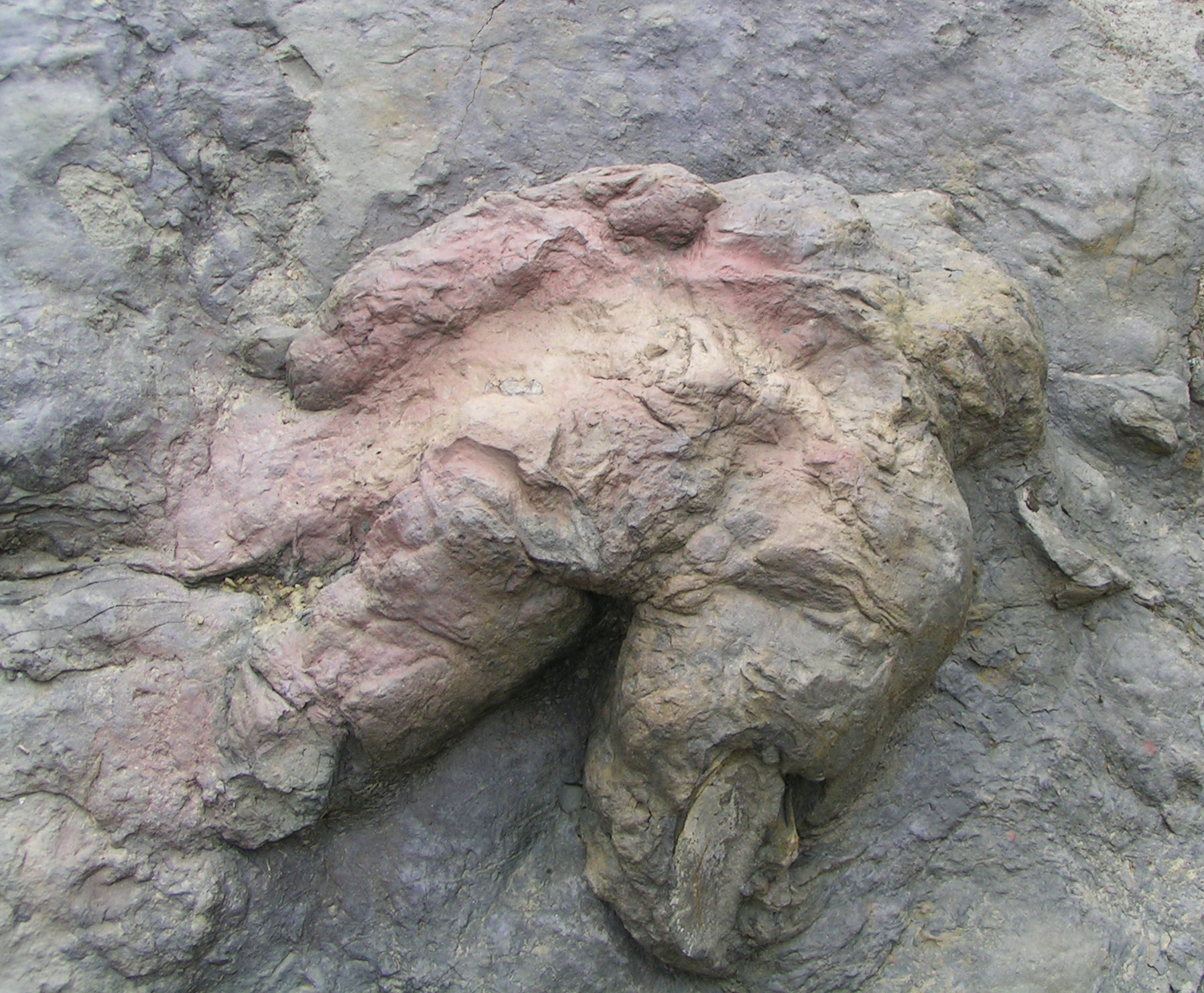
 Tyrannosaurus footprint, the only one known, near Anasazi
- Black Horse
- Location: North Country
- Black Jacks
- Location: North Country
- Buck Creek
- Elevation: 9,200 feet (2,804.2 m); location: South Country, 36°24′40″N 105°07′49″W / 36.41111°N 105.13028°W
- Cathedral Rock
- A stream-side camp shadowed by Cathedral Rock, this campsite is also close to other natural wonders such as Hidden Valley and Window Rock. Elevation: 7,350 feet (2,240.3 m); location: Central Country, 36°29′03″N 105°02′22″W / 36.48417°N 105.03944°W
- Comanche
- A stream-side camp with plenty of water. Not to be confused with Comanche Peak Camp. Elevation 9,600 feet (2,926.1 m);location: South Country, 36°26′50″N 105°09′40″W / 36.44722°N 105.16111°W; water: stream; facilities: latrine and sump.
- Comanche Peak
- A dry camp located immediately to the east of Mount Phillips, Comanche Peak is spacious and well-shaded by ponderosa pines. Provides views of sunsets over Mounts Phillips and Baldy. Wildlife, including mule deer, elk and black bear, abounds in this area. Elevation 11,100 feet (3,383.3 m) ft.; location: Central Country, 36°28′50″N 105°08′14″W / 36.48056°N 105.13722°W; water: none; facilities: latrine.
- Copper Park
- A wet camp hidden among the trees on the side of Mount Baldy, Copper Park is a beautiful campsite, and a common place for crews to stay two nights in order to ascend Mount Baldy. The nearest commissary is Baldy Camp. Elevation 10,500 feet (3,200.4 m) ft; location: North Country, 36°38′31″N 105°12′06″W / 36.64194°N 105.20167°W water: spigot.
- Cook Canyon
- Location: North Country
- Cottonwood Trail
- Location: North Country
- Crags
- Crags is located on the banks of Rayado creek southeast of Fish Camp. location: South Country.
- Deer Lake
- Depending on the season, this camp can be wet or dry. Located next to a small lake that has recently been affected by drought. Also only about 1 hour (1.5 mi.) from Harlan; many crews decide to hike to Deer Lake and come back down to Harlan in order to get water or participate in burro racing. Elevation: 8,300 feet (2,529.8 m); location: Central Country, 36°30′35″N 105°01′42″W / 36.50972°N 105.02833°W
- Deer Lake Mesa
- Location: Central Country
- Devil's Wash Basin
- Elevation: 8,500 feet (2,590.8 m);location: Central Country, 36°31′20″N 105°03′23″W / 36.52222°N 105.05639°W
- Elkhorn
- Location: North Country
- Ewells Park
- Location: North Country
- This camp is located near Baldy Town, and some treks stay here when attempting Baldy Mountain.
- Greenwood Canyon
- Location: North Country
- House Canyon
- North country trail camp between Anasazi and Old Camp, opened in 2007.
- Lambert's Mine
- An unstaffed camp relatively close to Cypher's Mine Camp with several abandoned mineshafts in the vicinity Elevation: 9,000 feet (2,743.2 m); location: Central Country, 36°28′35″N 105°06′21″W / 36.47639°N 105.10583°W
- Lost Cabin
- Located slightly east and south of Apache Springs, a staffed camp, Lost Cabin is the former location of a mining operation and cabin. It served as a staffed camp in 1963, but was flooded in 1965 and permanently replaced by Apache Springs. Elevation: 9,200 feet (2,804.2 m); location: South Country, 36°23′02″N 105°08′10″W / 36.38389°N 105.13611°W
- Lookout Meadow
- Elevation: 9,400 feet (2,865.1 m); location: South Country, 36°23′00″N 105°04′00″W / 36.3833333°N 105.0666667°W
- Lovers Leap
- Elevation: 7,400 feet (2,255.5 m); location: South Country, 36°25′14″N 105°00′41″W / 36.42056°N 105.01139°W
- Lower Sawmill
- Located just over a mile downhill and east of Sawmill, this camp is located near a beautiful alpine meadow.; location: Central Country; water: A nearby stream provides clear water
- Maxwell
- Location: North Country
- McBride Canyon
- Location: North Country
- Mt. Phillips
- Mt. Phillips Camp, located atop Mount Phillips, the second tallest mountain on the ranch, this is the highest camp in Philmont and provides excellent views. Elevation: 11,711 feet (3,569.5 m); location: Central Country; water: none.
- New Dean
- Location: North Country
- North Fork Urraca
- Location: South Country
- Old Camp
- Location: North Country
- Ponderosa Park
- Located relatively close to Clarks Fork (albeit entirely uphill), it is the final camp on several itineraries. Location: Central Country
- Porcupine ("Porky")
- Common camp for the day after Mt. Phillips, this camp features an abandoned cabin and campsites along Rayado Creek. This was once a staffed camp, usually comprising a single staff member that served more as a camp host than a program counselor. Also featured in the Philmont Ranger Song. Location: South Country
- Pueblano Ruins
- Satellite camp for the staffed camp of Pueblano. Campers often do program activities and enjoy the evening campfire at nearby Pueblano. Elevation: 8,400 feet (2,560.3 m); location: North Country, 36°37′44″N 105°08′06″W / 36.62889°N 105.135°W.
- Rayado River
- South Country
- Red Hills
- Central Country
- Rimrock Park
- South Country
- Santa Claus

- Santa Claus was a staffed camp until the mid-1990s. One of the main reasons it closed was because the well stopped pumping enough water to sustain a full staff. The area suffered during the 2002 Ponil Complex fire, though the abandoned cabin still stands.
- In 2000, lightning struck one of the bear cables and the bear bags on the line exploded, leaving the trees charred from where the bear cables were attached.
- Elevation: 8,400 feet (2,560.3 m); location: North Country, 36°35′27″N 105°05′22″W / 36.59083°N 105.08944°W.
- Shaefers Pass
- This trail camp is just below Shaefer's Peak and is a good location for watching a sunrise or sunset on the peak. A side hike to the Tooth of Time is also popular. As of July 2007, this is a seasonally dry camp. Location: Central Country
- Sioux
- Located just above Ponil camp, this dry camp is a common starting camp for treks. Elevation: 7,380 feet (2,249.4 m); location: North Country 36°37′18″N 105°03′18″W / 36.62167°N 105.055°W
- Stockade
- Location: South Country
- Tooth Ridge
- Tooth Ridge Camp is often the last camp that backpacking crews use before a return back to Philmont's base camp. Tooth Ridge Camp sits immediately beneath The Tooth of Time (elevation 9,003 feet (2,744.1 m) feet) and itself sits at 8,240 feet (2,510 m) in the midst of tall, broad ponderosa pines.
- It is ideally positioned for an early morning ascent of the Tooth.
- This is a dry camp, so crews must pack in their own water for their last night on the trail.
- Sites: 18; elevation: 8,240 feet (2,511.6 m); location: Central Country, 36°27′16″N 104°59′50″W / 36.45444°N 104.99722°W; water: none; facilities: none; program: bouldering.
- Toothache Springs
- Location: South Country
- Thunder Ridge
- Location: Central Country
- Turkey Creek
- Location: North Country
- Upper Bench
- Beautiful dry trail camp with a series of seasonal lakes, and a large, rock formation on one end. Location: Central Country
- Upper Clark's Fork
- A camp up above the staffed Clark's Fork, this quiet and scenic camp is nestled in the Ponderosa Pines and sits along a fairly well-used trail. Not to be confused with Clark's Fork, however many campers day-hike down to Clark's Fork to get a chuckwagon dinner and showers. 36°27′37″N 105°2′56″W / 36.46028°N 105.04889°W
- Upper Dean Cow
- This camp has a spigot with untreated water. It is a grassy camp near a river and is frequented by mule deer. It is also a common place to see a black bear. Location: North Country
- Ute Springs
- This trail camp is a typical first night camp. It features a red roof inn and stone seats.; location: Central Country; water: A clear nearby stream
- Ute Meadows
- This camp is located just below Baldy Town and is used as a layover camp for crews climbing Baldy; location: North Country
- Vaca
- This camp has an unpurified solar well and is located on a large meadow of Black Eyed Susans, it is a short hike to Harlan staffed camp. Location: Central Country
- Visto Grande
- This large trail camp, which is on a steep hill, is near a fantastic view of Baldy Mountain. It also contains a spring for water. An abandoned building also sits in this camp. Location: Central Country
- Webster Lake
- Location: Central Country
- Webster Parks
- Not far from the large, staffed camp, Cimarroncito, it is located next to a beautiful meadow and crews have the option of day hiking down to Cimarroncito and catching rock-climbing lessons and water. Location: Central Country
- Wild Horse
- Location: South Country
Staffed camps
- Abreu
- A Mexican homestead beloved for its Cantina, which serves snacks and root beer. Its other program includes a Mexican dinner, goat-milking, chicken-chasing, and other farm-related activities and maintenance. It is set in the year 1912. Elevation: 7,240 ft (2,210 m).; location: South Country; water: purified from spigot; facilities: showers, latrines.
- Apache Springs
- Located in the far southwest corner of the ranch, Apache Springs sits on the edge of a large alpine meadow. While not an interpretive history camp (staff are not dressed in period clothing) the program relates the history and culture of the Jicarilla Apache who inhabited the region up until the mid 19th century. The camp features a small "village" of teepees where talks are given on the history and lifestyle of the Jicarilla as well as the opportunity to handle genuine artifacts. Scouts also have the opportunity to make real arrowheads and experience a "sweat lodge". Elevation: 9,400 ft (2,900 m).; location: South Country, 36°23′16″N 105°08′36″W / 36.38778°N 105.14333°W
- Baldy Town
- Baldy Town is a, now-abandoned, formerly bustling town located at the base of Mount Baldy in Colfax County, New Mexico. Baldy Town, which served as the base of gold mining operations on the mountain, figured prominently in Old West culture and folklore, but was completely abandoned when mining in the area ceased.
- In 1963, this area was purchased through the generosity of Norton Clapp, vice-president of the National Council of the Boy Scouts of America and added to the Philmont Scout Ranch. This added 10,098 acres (41 km²) to the property which had been donated to the Boy Scouts of America by oil magnate Waite Phillips.
- Among its ruins, at an elevation of 10,000 feet (3,000 m), Philmont now runs a staffed camp and commissary, which includes a trading post and showers. Its programs include a history of the town and climbing the Baldy Mountain, which, at an elevation of 12,441 feet (3,792 m), is the highest on the ranch.
- Beaubien
- Located at the northerly end of picturesque Bonita Canyon, Beaubien is largely considered the hub of the South Country. Virtually all treks that route through the South Country come here. Some treks spend a "layover" here, i.e. they stay here for two nights allowing for a little R&R during their trek. The program features the life of the cowboy, both historical and modern, with horseback rides, branding, a chuckwagon dinner prepared (partially) by the staff, and a western campfire. Many campers choose to brand their hiking boots, belts, and other brandable articles with either the Slash Crazy S and/or the Bar P Crazy S brands of Philmont. Beaubien is named in honor of Carlos Beaubien who, along with Guadalupe Miranda, owned the original Mexican land grant of which Philmont is now a part.
- Black Mountain

- A log cabin assumed to be constructed in 1895 as part of a hydraulic mining operation sits next to the blacksmithing forge, campfire ring, and rifle range. Crews who come here take a step back in time in a way that few other interpretive history camps at Philmont are able to do. The program is a hybrid of homesteading, mining, and early western settlement, set in reconstruction era America. Staff portray the roles of civil war veterans who have come west to carve out new lives, work for the Cimarron Indian Agency, and perhaps begin a settlement. Black powder shooting skills and blacksmithing are taught in a manner where participants can appreciate the range of skills that were necessary to settle the West. Because this camp is inaccessible to vehicles, burros are used to bring provisions in and garbage out of camp. For this reason, the staff do not accept garbage from crews. The camp is located along the North Fork Urraca Creek at the southwesterly base of Black Mountain, one of the more prominent peaks on the ranch. Latrines are back-to-back and sit in the open.
Elevation = 9,040'; 36°26.58′N 105°05.50′W / 36.443°N 105.0917°W; water: stream, must be treated
- Carson Meadows
- Opened in the summer of 2004, Carson Meadows was converted to a staff camp during the summer of 2005 it is the southernmost camp on the Ranch. Located above the Rayado Canyon to the south, it is a short hike from Abreu, turning south at the Old Abreu trail camp. Carson Meadows is situated on, as the name implies, a gorgeous meadow surrounded by thick woods. From the gorgeous cabin one has a spectacular view of the Tooth of Time, framed by Fowler Mesa to the east and Urraca Mesa to the west. Carson's program is search and rescue.
- Cimarroncito
- The hub of the Central Country, this camp provides rock climbing and an excellent conservation site. Its conservation staff have been working to restore the meadow to its former state in order to improve the water table for the village of Cimarron. The camp also features chapel services.
- Clark's Fork
 Clark's Fork Patch
- A western program, with horseback rides, branding, chuckwagon dinners and a western campfire. A very busy camp and typically gets extremely crowded with crews moving in both directions. The camp also contains a steer-roping practice area and two sets of horseshoe pits
- Due to its proximity to Philmont's base camp and its function as a funnel for crews finishing their treks via the Tooth of Time, Clark's is a large and busy camp. For dinner, Scouts and leaders are served a "chuckwagon" beef stew, a signature of Philmont. Many crews take trail rides on the camps horses. Rides can be reserved in advance by crew leaders.
- Clark's Fork is an excellent place to get belts, boots and other gear branded with the Philmont horse brand or cattle brand.
- Sites: 21; elevation: 7,530'; 36°28′07″N 105°02′54″W / 36.46861°N 105.04833°W; water: in-camp spigots; facilities: showers; program: Western Lore, Horse Rides, Chuckwagon Dinner.
- Clear Creek
- This camp features the history of the fur trade prior to 1840. Program includes loading and shooting muzzleloading blackpowder rifles, a demonstration of beaver trapping techniques, tomahawk throwing, and a talk on the history of the North American fur trade and examination of artifacts in the "trappers cabin". Evening activities consist of the telling of "yarns", or folklore tales from the days of the fur trade. At approximately 10,200 feet (3,100 m), Clear Creek is the highest staffed camp on the ranch. Cold, wet weather (even snow) is not uncommon during the summer months at this elevation. Clear Creek is located near the headwaters of the Rayado River and is named after the original name of Mt. Phillips, Clear Creek Mountain. The actual Clear Creek flows off of the north side of Mt. Phillips within the Cimarron Canyon Wildlife Area.
- Crater Lake
- This camp sits on a large incline above 8000 ft on the eastern slopes of Fowler Pass between Fowler Mesa and Trail Peak. The theme of the camp is early 20th century logging, and staff portray the Continental Tie and Lumber Company, which actually operated to the north in the Ponil Canyons. Activities include spar pole climbing and hand-hewn railroad tie construction. The staff also hosts a campfire with a magnificent view of the Tooth of Time. The lake more closely resembles a pond and is not actually located in a crater. It was formed by a rock slide from the slopes of Fowler Mesa which created a natural bowl fed by a spring.
- Crooked Creek
- One of the more primitive staffed camps, Crooked Creek is similar to Black Mountain in that it is not accessible by vehicle. The camp is located on the edge of a large, high meadow and features programs related to the life of the homesteader. An early staffed camp many years ago, Crooked Creek was a trail camp until 1990, when it was decided that homesteading would be a good addition to Philmont's interpretive history camps. In 1990, Crooked Creek was among the first camps (along with Cimmaroncito and Abreu) in Philmont's history to feature a coed staff. Like many other of Philmont's interpretive history camps, the staff live as primitively as the life they portray. Gardening, candle making, livestock care, woodworking skills, and lively games of "mountain bowling" are some of the activities presented here. Like many of the other staffed camps, Crooked Creek has featured a bluegrass band composed of staff members.
- Cypher's Mine
- This camp is located along the upper reaches of the North Fork Cimarroncito River. The program revolves around gold and other "hard rock" mining that historically occurred in the area. Program activities are highlighted by a tour of the Contention mine. Another larger mine known as the Thunder exists just south of the camp as do smaller mines such as the Garst, the Gloria, and the Anaconda, but they are not the subject of any program activities. Other program activities include blacksmithing and goldpanning. The camp is named in honor of Charles Cypher, an early miner in the area. Cypher's Mine is the only camp on the ranch where crews do not pitch tents at their campsites. Due to the narrow, rocky canyon in which the camp is located, campsites contain three-walled roofed structures officially referred to as "adirondacks", but the local camp vernacular for them is "shacks". A variety of original structures and artifacts from the mining days of the late 19th century are featured at this camp. Cypher's Mine features an evening program called a "Stomp" inside one of the old structures, modeled after the evening revelry of miners.
- Dan Beard
- Elevation: 7,990 ft (2,440 m).; location 36°40′42″N 105°05′15″W / 36.67833°N 105.0875°W. Located in the burn, Dan Beard is a home to a challenge course, a program designed to teach teamwork and critical thinking skills within a group. In 2006, Dan Beard received a new challenge course wall and new campsites to compensate for those lost in the Ponil complex fire. Three sites are located a short hike up a hill in the canyon, while the rest of the camp sites are nestled in the hills behind the challenge course.
- Dean Cow
- Located just outside the burn area (from the Ponil Complex Fire), this camp offers arguably the most difficult participant rock climbing on the ranch. Other activities include rappelling as well as a traverse wall for use in the evening hours. The cabin offers the famous "porch challenge," a series of climbing holds, ropes, and crimps across the porch. Those who complete the porch challenge usually receive a small prize, such as a pudding cup. Dean Cow's other popular "activity" is its heated showers available to participants. Staff at Dean Cow often spend down time climbing the canyon's multiple, challenging walls. From 1990 to 2009, Dean Cow offered a climbing wall for use during evening hours. For Summer 2010, the climbing wall was replaced with a traverse wall. As of August 2010, the old climbing wall still stands, but with the hand-holds removed. The staff will offer a small prize (usually a food item) to a camper who completes the traverse wall.
- Fish Camp
- Formerly known as Rayado Lodge, Fish Camp is the site of the three original hunting and fishing lodge of Waite Phillips, located in the South Country. The camp is first person interpretive, and program includes lodge tours, fly tying, and fly fishing. Fish Camp is notable as one of Waite Phillips's "favorite spots on the Ranch," according to son Chope who visits every year.
- French Henry
- Located in a deep, narrow canyon just below Baldy Mountain, French Henry features programs revolving around the rich mining history of the Baldy Country. Gold panning, blacksmithing, and a tour of a small portion of the massive Aztec mine are featured here. The mine tour is in an access drift within the Ponil Level 2 of the Aztec Mine, which at its height, contained over 30 miles (48 km) of tunnels and other workings. The main part of this camp contains the foundations of an old ore mill. Waste from this mill results in the only place on Philmont where crews can consistently find actual gold in their pans. The staff lives in original structures built in 1930s. The camp is named in honor of Henry Buruel, a Frenchman who mined in the area as early as 1869. Stories of his untimely death in neighboring Baldy Town have led to numerous legends of his haunting of this camp. This is the only non-commissary camp with no overnight campers due to the lack of flat areas for campsites. Elevation: 9,650 ft (2,940 m).; location: North Country, 36°38′10″N 105°11′00″W / 36.63611°N 105.1833333°W.
- Harlan
- Harlan is the place for 12-gauge shotgun shooting (shooting clay pigeons), and burro racing; a popular Harlan sport in which each crew races their burro around certain obstacles in attempt to beat the other crews' burros.
- Head of Dean
- This North Country camp is home to a magnificent view of the Rockies in back of the staff cabin, as well as a basketball court, many hummingbirds, a weather station, a turkey family, and team-building challenge events. These are challenges such as getting an entire crew up a sheer 12-foot (3.7 m) wall.
- Hunting Lodge
- Centered on the well-maintained cabin built by Waite Phillips for his many hunting excursions, the Hunting Lodge is located in a busy area of the ranch's central country, and serves as a hub for vehicles and for trekkers passing between Cypher's Mine, Clark's Fork and Cimarroncito. It also serves as a major attraction for the youth participants of the Philmont Training Center. Program includes a tour of Phillips' cabin and evening stories told by the fireplace.
- Indian Writings
- Indian Writings hosts many petroglyphs on the large rock faces around the camp. Also there are a few excavation sites and archaeological digs corresponding to these ancient writings, each with their own stories. Campers usually take the hour to an hour and a half tour of the easy-to-reach writings and excavation sites. Both new and exiting scouts are found here, as it is located close to 6-Mile Gate turnaround.
- Miners Park
- This South Country camp is noted for its rock climbing and traverse wall. The camp is built around a large meadow, in which mountain lions may appear to hunt mule deer and other such prey. The program area is arguably the farthest on the ranch from the actual campsites, typically a 30-minute hike up to the rock formation known as "Betty's Bra." In the evening it is possible to hear Crater Lake staff and campers yell to the "hippie climbers" of Miners Park during their campfire program.
- Miranda
- This North/Baldy Country camp is home to a large meadow with a black powder rifle range along with a throwing tomahawk range. The staff portray a mountain man/fur-trappers rendezvous, and display various trappers and traders wares in the tee-pees in the meadow. Miranda is noted for its evening activity, Mountain Ball, a variant of baseball with five bases and two teams in the field at any one time. After Mountain Ball, it is tradition for all participants to yell "We are the finest Mountain Ball players in all the land! Bring us your finest meats and cheeses!" towards Head of Dean camp. As it is uncommon for crews to beat the staff in Mountain Ball, crews that do defeat the staff become honorary members of the AKC, a legendary crew who first beat the staff in an epic game, winning 21-2-0. As of July 2006, the camp is suffering from bear problems.
- Ponil
- The former base camp for the Philturn Rocky Mountain Scout Camp, Ponil not only has a commissary but also contains a trading post. Ponil provides camping and a Western Lore program. Western lore program includes: A cantina, cantina show, chuckwagon dinner and breakfast, lassoing, branding, and horse shoes. Crews can learn from the wrangler staff how to pack burros at Ponil, and then take them along to their next camp. There is a fifty pound weight limit for how much the burros can carry, which typically is equal to three days of trail meals. Many crews also take horseback/dude rides here, in which the wrangler staff take you on a scenic view of the forest and surrounding area. Ponil is also the starting and ending location for many North Country Cavalcades, where instead of backpacking for 10 days, a crew can ride horses from camp to camp along a set itinerary. Elevation: 7,050 ft (2,150 m).; location: North Country, 36°37′56″N 105°00′07″W / 36.63222°N 105.00194°W
- Phillips Junction
- Phillips Junction (PJ) is a Commissary (a food pickup for crews) and a moderately-stocked trading post. They offer unlimited free apples and oranges for crews going through. It has water purified from spigot, showers and latrines. No camping. PJ's not a destination- it is used almost exclusively as a food pickup.
- Pueblano
- Setup as a mock logging camp of the Continental Tie and Lumber Company, Pueblano offers theme oriented program. The program offers spar pole climbing and hand-hewn railroad tie construction during the day, and "Loggerball" and a campfire in the evening. Loggerball is a game similar to baseball. The camp staff, known as the Log Dogs, always beat the campers. The rules change each inning, and the staff members make lots of noise during the reading of the rules in order to confuse the campers. Elevation: 8,100 ft (2,500 m).; location: North Country, 36°37′30″N 105°06′51″W / 36.625°N 105.11417°W.
- Rayado
- Located 7 miles (usually traveled by bus) from base camp. Great activity to do on first/last day in base camp. Features a replica 1860's hacienda built on property once owned by mountain man Kit Carson. Program offered: Interactive 1-hour tour of the Kit Carson Museum, may include demonstrations of blacksmithing, black-powder riflery, woodworking, cooking, or tomahawk throwing. This is one of the few areas of Philmont open to the public. Hours of Museum 8-5, every day during the summer season.
- Rich Cabins
- Although considered a part of the ranch, Rich Cabins is outside of the Philmont boundary on Ted Turner's Vermejo Park Ranch. The Rich family lived at this location from the late 1880s to the 1920s and therefore the camp and its program is focused on that homesteading era. Program includes: historical cabin tours, gardening, wood working (some years), catching chickens, milking cows, and various projects that the staff may be working on to improve the camp. Additionally, there is a commissary located at Rich.
- Ring Place
- Found in the Valle Vidal, this camp has astronomy, folk weather, and cabin tours of their historic cabin.
- Sawmill
- Sawmill has a wood-fired boiler for hot showers and a program focused on high-powered rifle shooting (.30-06) where participants are taught how to re-load their own rounds and to shoot. Has a beautiful view down the valley towards the east and the prairie below. Highly recommended to wake up early and watch sunrise, as the sun rises in the valley below, and provides for unforgettable views.
- Seally Canyon
- A Valle Vidal camp. The program feature is search and rescue.
- Urraca
- A camp sited on the north side of Urraca Mesa with a great view to the North looking toward Base Camp. Inspiration Point is a great side hike from this camp. The camp program includes challenge (team building) activities designed to help instill a sense of teamwork within the crew while teaching them to be willing and ready to think outside the box. Campsites are neatly separated from the program area and sited along a hillside in the Ponderosa pines next to a meadow; cool breezes funnel down Urraca and the adjacent passes. Most crews arrive at Urraca after climbing up and over Urraca Mesa. Legend holds that the Mesa is haunted, with tales ranging from eerie blue lights to "imps" running around at night. Crews crossing the mesa might encounter some cattle.
- Ute Gulch Commissary
 Ute Gulch Commissary
- Commissary and trading post; no camping. This is a trail outpost with the commissary on one end of the building and the trading post on the other.
- The trading post carries primarily the bare essentials-- but also a few other goodies to eat and drink which are a welcome respite from trail food.
- Offers fresh fruit to those picking up food. After experiencing extreme bear problems in 2005, Ute Gulch Commissary became one of the first commissaries to use electric fences around the building.
- It sits at 7,920 feet (2,410 m) elevation and is located at 36°30.80′N 105°03′W / 36.5133°N 105.05°W.
- Whiteman Vega
- A Valle Vidal camp. It features Mountain Bike riding and also provides an excellent starting point for any layover crews that would like to hike Little Costilla, a demanding and yet rewarding mountain west by north-west of the camp.
- Zastrow
- Location: South Country
- This staffed camp is home to the land navigation program, and is a common camp to pass through or stay at for crews at the beginning or end of their south country treks. Crews that stay the night can make fruit cobbler for dessert.
See also
Categories:- Philmont Scout Ranch
- Buildings and structures in Colfax County, New Mexico


Wikimedia Foundation. 2010.