- North Willoughby, New South Wales
-
North Willoughby
Sydney, New South Wales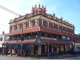
Willoughby Hotel, Penshurst StreetPostcode: 2068 Location: 9 km (6 mi) north of Sydney CBD LGA: City of Willoughby State District: Willoughby Federal Division: North Sydney Suburbs around North Willoughby: Chatswood Chatswood Castle Cove Chatswood North Willoughby Middle Cove Willoughby Willoughby East Castlecrag North Willoughby is a suburb on the lower North Shore of Sydney, in the state of New South Wales, Australia. North Willoughby is located 9 kilometres north of the Sydney central business district, in the local government area of the City of Willoughby. Willoughby and Willoughby East are separate suburbs.
Contents
Commercial areas
A small group of shops and cafes is located on Penshurst Street and includes the Willoughby Hotel, a local landmark building. The hotel was established in 1899 and was described as "one of the finest buildings in the northern suburbs".[1] It was almost demolished in 1940, but survived and had a major restoration in 1988.
Another landmark is Rosewall, a two-storey home in the Georgian style, made of sandstone. It was built in the 1880s for the Forsyth family, who ran tanneries in the area.
The High Street Markets in High Street include various local shops.
Churches
St John's Anglican Church
References
External links
- North Willoughby, New South Wales is at coordinates 33°47′42″S 151°12′14″E / 33.795°S 151.204°ECoordinates: 33°47′42″S 151°12′14″E / 33.795°S 151.204°E
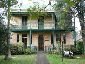 Rosewall
Suburbs of City of Willoughby · North Shore · Sydney Artarmon · Castlecrag · Castle Cove · Chatswood · Gore Hill · Middle Cove · Naremburn · Northbridge · Roseville · St Leonards · WilloughbyCategories:- Suburbs of Sydney
- Sydney geography stubs


Wikimedia Foundation. 2010.