- Altötting (district)
-
Altötting — District — 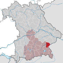
Country  Germany
State Bavaria Adm. region Oberbayern Capital Altötting Area - Total 569 km2 (219.7 sq mi) Population (31 December 2010)[1] - Total 107,711 - Density 189.3/km2 (490.3/sq mi) Time zone CET (UTC+1) - Summer (DST) CEST (UTC+2) Vehicle registration AÖ Website http://www.lra-aoe.de Altötting is a district in Bavaria, Germany. It is bounded by (from the east and clockwise) Austria and the Bavarian districts of Traunstein, Mühldorf and Rottal-Inn.
Contents
History
Altötting was one of the original parts of Bavaria. It was settled by Bavarian tribes shortly after the retreat of the Romans. During the rule of duke Tassilo III (748-788) the place of Ötting was mentioned for the first time (the towns of Altötting and Neuötting are derived from that place). Soon in the 9th century the region became a religious centre with famous churches and monasteries. In the 15th century it became a place of pilgrimage.
The district of Altötting was established in 1837. The current Pope Benedict XVI was born here 1927 in the village of Marktl.
The hearts of many of the rulers of Bavaria are buried in the chapel of Mercy in the middle of the town square.
Geography
The district is located in the alpine upland on the Austrian border. The main axis of the region is the Inn River, which crosses the district from west to east. It is joined by two large tributaries, the Alz River coming from the south and the Salzach, which forms the eastern border of the district. In addition there are several smaller rivers and brooks. The district once was covered with deciduous forests, but is now mainly agriculturally used. However, there are some nature reserves along the lower Alz River and at the mouth of the Salzach River.
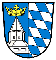
Coat of arms
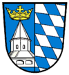
The coat of arms displays: - left: the chapel of pilgrimage in the town of Altötting
- right: the blue and white checked pattern of Bavaria
Towns and municipalities
Towns Municipalities - Altötting (1)
- Burghausen (2)
- Neuötting (14)
- Töging am Inn (20)
- Burgkirchen (3)
- Emmerting (4)
- Erlbach (5)
- Feichten (6)
- Garching (Alz) (7)
- Haiming (8)
- Halsbach (9)
- Kastl (10)
- Kirchweidach (11)
- Marktl (12)
- Mehring (13)
- Perach (15)
- Pleiskirchen (16)
- Reischach (17)
- Stammham (18)
- Teising (19)
- Tüßling (21)
- Tyrlaching (22)
- Unterneukirchen (23)
- Winhöring (24)
References
- ^ "Fortschreibung des Bevölkerungsstandes" (in German). Bayerisches Landesamt für Statistik und Datenverarbeitung. 31 December 2010. https://www.statistikdaten.bayern.de/genesis/online?language=de&sequenz=tabelleErgebnis&selectionname=12411-009r&sachmerkmal=QUASTI&sachschluessel=SQUART04&startjahr=2010&endjahr=2010.
External links
- Official website (German)
- Inofficial website (German)
Categories:- Districts of Bavaria

Wikimedia Foundation. 2010.