- Moncrieff, Australian Capital Territory
-
Moncrieff
Canberra, Australian Capital Territory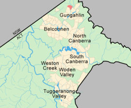
Postcode: 2914 District: Gungahlin Suburbs around Moncrieff: Taylor Jacka Bonner Taylor Moncrieff Ngunnawal Amaroo Moncrieff is a designated suburb of Gungahlin, Canberra, the National Capital of Australia. The name was gazetted in April 1991 though no official announcement has to be made about the first land release. It is named after Gladys Moncrieff, an Australian singer of the 1920-30s musical era who was dubbed 'Australia's Queen of Song'. The suburb is located in north Gungahlin adjacent to the existing suburb of to the suburbs of Ngunnawal, Amaroo and the future suburbs of Taylor and Jacka. The suburb is located approximately 4 km from the Gungahlin Town Centre and 16 km from the centre of Canberra and is bounded by Mirrabei Drive and Horse Park Drive.
Contents
Future Development
When fully developed Moncrieff is expected to accommodate approximately 1800 dwellings.[1] and a variety in housing types including:
- Standard residential;
- medium and higher density residential (consistent with the provisions of Residential B8 and B9 Area Specific Policies of the Territory Plan) adjacent to the commercial centre, main community facility site and along Horse Park Drive;
- Compact block housing in the locations identified in the Compact Block Housing for New Estates; and
- “Affordable housing” in accordance with the Affordable Housing Action Plan.
A group shopping centre together with higher density housing is to be located near the intersection of Horse Park and Mirrabei Drives.[1]
Geography
With an area of approximately 200ha , of which only 130ha is developable, the suburb of Moncrieff is relatively small compared to other Gungahlin suburbs. Three hills dominate the area, the highest which is 674 meters above sea level. The green belt is characterised by Yellow Box-Red Gum Woodlands, lowland woodland and grasslands.[1]
Geology
The rock under Moncrieff consists of Canberra Formation of middle Silurian age. It consists of shale, slate, and mudstone.[2]
References
Coordinates: 35°09′43″S 149°06′43″E / 35.162°S 149.112°E
Categories:- Suburbs of Canberra
- Australian Capital Territory geography stubs

Wikimedia Foundation. 2010.