- Denali State Park
-
Denali State Park 
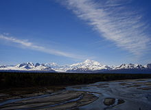
Byers Lake view of Denali and the Alaska RangeType Wilderness Location 147.1 Parks Highway,
north of Trapper Creek[1] Matanuska-Susitna Borough, Alaska, USACoordinates 62°46′12″N 150°03′12″W / 62.77°N 150.05333°WCoordinates: 62°46′12″N 150°03′12″W / 62.77°N 150.05333°W[2] Area 325,240 acres (131,620 ha) Created 1970 (expanded to present size
in 1976)Operated by Alaska State Parks Denali State Park is a 325,240-acre (131,620 ha) state park in the U.S. state of Alaska. It is located adjacent in the Matanuska-Susitna Borough [3]to the east side of Denali National Park and Preserve, along the Parks Highway.
The park is undeveloped wilderness with the exception of the two day-use areas, three campgrounds, and two trailheads accessible from the Parks Highway:[1]
- Alaska Veterans Memorial
- Denali Viewpoint South
- Byers Lake Campground, near Byers Lake
- Denali Viewpoint North Campground
- Lower Troublesome Creek Campground
- Upper Troublesome Creek Trail (closed in 2009 due to washouts caused by severe flooding)[4]
- Little Coal Creek Trail
See also
References
- ^ a b Alaska State Parks near Trapper Creek in the Susitna Valley
- ^ Denali National Park and Preserve - Aviation Reporting Coordinates (U.S. National Park Service)
- ^ U.S. Geological Survey Geographic Names Information System: Denali State Park
- ^ The Milepost 61st Edition, page 406 ISBN 978-1892-15426-2
External links
Categories:- Alaska state parks
- Wilderness Areas of Alaska
- Protected areas of Matanuska-Susitna Borough, Alaska
- Southcentral Alaska geography stubs
- Alaska geography stubs
- Western United States protected area stubs
Wikimedia Foundation. 2010.

