- Nannestad
-
Nannestad kommune — Municipality — 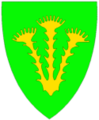
Coat of arms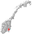
Akershus within
NorwayNannestad within Akershus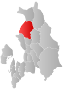
Coordinates: 60°14′44″N 10°57′10″E / 60.24556°N 10.95278°ECoordinates: 60°14′44″N 10°57′10″E / 60.24556°N 10.95278°E Country Norway County Akershus District Romerike Administrative centre Teigebyen Government - Mayor (2009) Anne Ragni Arntzen (Ap) Area - Total 341 km2 (131.7 sq mi) - Land 324 km2 (125.1 sq mi) Area rank 259 in Norway Population (2004) - Total 9,943 - Rank 102 in Norway - Density 31/km2 (80.3/sq mi) - Change (10 years) 23.0 % Demonym Nannestadsokning[1] Time zone CET (UTC+1) - Summer (DST) CEST (UTC+2) ISO 3166 code NO-0238 Official language form Bokmål Website nannestad.kommune.no Data from Statistics Norway Nannestad is a municipality in Akershus county, Norway. It is part of the traditional region of Romerike. The administrative centre of the municipality is the village of Teigebyen. Nannestad was established as a municipality on 1 January 1838 (see formannskapsdistrikt).
Contents
General information
Name
The municipality (originally the parish) is named after the old Nannestad farm (Old Norse: Nannastaðir), since the first church was built here. The first element is the genitive case of Nanni (an old Norse male name) and the last element is staðir which means "homestead" or "farm".
Coat-of-arms
The coat-of-arms is from modern times. They were granted in 1990. The arms show three yellow coltsfoot flowers on a green background. This is a flower that is prevalent in the area.[2]
Geography
Nannestad is located in northwestern Akershus county, with inhabitants concentrated at Romerikssletta. It includes the villages of Maura and Teigebyen, the latter being the administrative centre.
References
- ^ "Personnemningar til stadnamn i Noreg" (in Norwegian). Språkrådet. http://www.sprakrad.no/nb-no/Sprakhjelp/Rettskrivning_Ordboeker/Innbyggjarnamn/.
- ^ "Kommunevåpen". http://oddso.nvg.org/nlv/0238.html. Retrieved 2008-12-20. (Norwegian)
External links
 Media related to Nannestad at Wikimedia Commons
 The Wiktionary definition of Nannestad
- Municipal fact sheet from Statistics Norway
- Akershus travel guide from Wikitravel
- Municipality website (Norwegian)
Municipalities of Akershus  Categories:
- Municipalities of Akershus


Wikimedia Foundation. 2010.