- Nor Lípez Province
-
Nor Lípez — Province — James's Flamingos at Cañapa Lake, Colcha "K" Municipality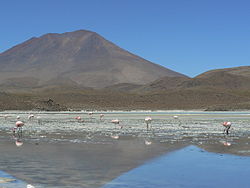
Flag
SealLocation of the Nor Lípez Province within Bolivia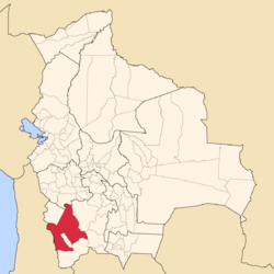 Provinces of the Potosí Department
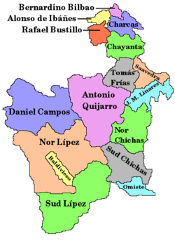
Coordinates: 21°14′0″S 67°27′0″W / 21.233333°S 67.45°W Country  Bolivia
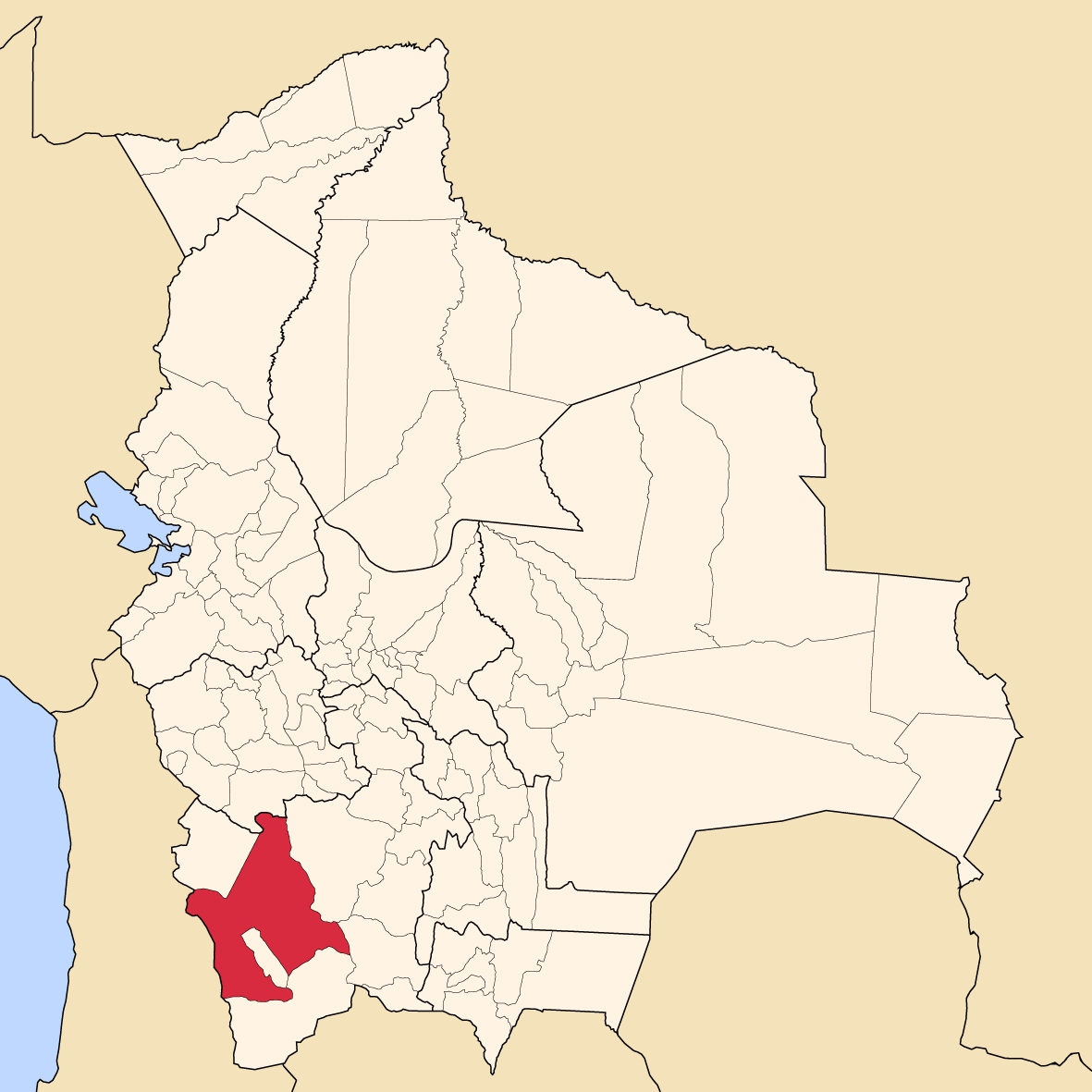
Department Potosí Department Capital Colcha "K" Area – Total 10,883.1 sq mi (28,187 km2) Population (2001) – Total 10,460 – Density 1/sq mi (0.4/km2) – Ethnicities Quechua Nor Lípez is a province in the Bolivian department of Potosí. Its seat is Colcha "K", also called Villa Martín. The majority of the province's area was titled as the Nor Lípez Native Community Land on 19 April 2011. One of Bolivia's largest mines, the San Cristóbal Mine, is located near San Cristóbal in Colcha "K" municipality.
Contents
Location
The province is one of sixteen provinces in the Potosí Department. It is located between 20° 27' and 22° 01' South and between 66° 18' und 68° 35' West.
It is bordered by the Daniel Campos Province to the north, the Republic of Chile to the west, the Enrique Baldivieso Province and Sur Lípez Province to the south, Sud Chichas Province to the east, and the Antonio Quijarro Province to the northeast.
The province extends over 270 km from east to west and 210 km from north to south.
Division
The province comprises two municipalities which are further subdivided into cantons.
Section Municipality Inhabitants 2001 [1] Seat Inhabitants 2001 1st Colcha "K" Municipality 9,645 Colcha "K" or Villa Martín 853 2nd San Pedro de Quemes Municipality 815 San Pedro de Quemes 508 Population
The population increased from 8,320 (1992 census) to 10,460 inhabitants (2001 census), an increase of 25,7 %.
96 % of the population have no access to electricity, 93 % have no sanitary facilities. 61 % of the population are employed in agriculture, 9 % in mining, 2 % in industry, 28 % in general services. 90 % of the population are Catholics, 6 % are Protestants.
The people are predominantly indigenous citizens of Quechuan descent. [2]
Ethnic group Colcha „K“ Municipality (%) San Pedro de Quemes Municipality (%) Quechua 88.3 45.0 Aymara 5.6 6.3 Guaraní, Chiquitos, Moxos 0.1 0.2 Not indigenous 6.0 48.3 Other indigenous groups 0.1 0.2 Languages
The languages spoken in the province are mainly Spanish and Quechua.
Language Colcha „K“ Municipality San Pedro de Quemes Municipality Quechua 7,256 187 Aymara 333 67 Guaraní 1 0 Another native 2 0 Spanish 7,932 721 Foreign 28 3 Only native 878 1 Native and Spanish 6.616 222 Only Spanish 1.319 499 Ref.: obd.descentralizacion.gov.bo
Places of interest
- Cañapa Lake
- Chiguana Lake
- Hedionda Lake
- Kara Lake
- Olca volcano
- Ollagüe volcano
- Paruma
- Pastos Grandes Lake
- Sarapuro volcano
- Sonequera mountain
- Tapaquilcha mountain
References
- ^ INE, Bolivia
- ^ obd.descentralizacion.gov.bo
External links
Coordinates: 21°14′S 67°27′W / 21.233°S 67.45°W
 Potosí DepartmentCapital: Potosí
Provinces Alonso de Ibáñez • Antonio Quijarro • Bernardino Bilbao • Charcas • Chayanta • Cornelio Saavedra • Daniel Campos • Enrique Baldivieso • José María Linares • Modesto Omiste • Nor Chichas • Nor Lípez • Rafael Bustillo • Sud Chichas • Sur Lípez • Tomás Frías
Municipalities (and seats) Acasio (Acasio) • Arampampa (Arampampa) • Atocha (Atocha) • Betanzos (Betanzos) • Caiza "D" (Caiza "D") • Ckochas (Ckochas) • Caripuyo (Caripuyo) • Chaquí (Chaquí) • Chayanta (Chayanta) • Chuquihuta (Chuquihuta) • Colcha "K" (Colcha "K") • Colquechaca (Colquechaca) • Cotagaita (Cotagaita) • Llallagua (Llallagua) • Llica (Llica) • Mojinete Municipality (Mojinete) Ocurí (Ocurí) • Pocoata (Pocoata) • Porco (Porco) • Potosí (Potosí) • Puna (Puna) • Ravelo (Ravelo) • Sacaca (Sacaca) • San Agustín (San Agustín) • San Antonio de Esmoruco (San Antonio de Esmoruco) • San Pablo de Lípez (San Pablo de Lípez) • San Pedro de Buena Vista (San Pedro de Buena Vista) • San Pedro de Quemes (San Pedro de Quemes) • Tacobamba (Tacobamba) • Tahua (Tahua) • Tinguipaya (Tinguipaya) • Tomave (Tomave) • Toro Toro (Toro Toro) • Tupiza (Tupiza) • Uncía (Uncía) • Urmiri (Urmiri) • Uyuni (Uyuni) • Villazón (Villazón) • Vitichi (Vitichi) • Yocalla (Yocalla)Categories:


Wikimedia Foundation. 2010.