- Ottawa Regional Road 174
-
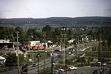 Highway 17 & Champlain St. intersection at Place D'Orleans in 1982
Ottawa Regional Road 174, commonly referred to as Highway 174, is a regionally maintained road in the city of Ottawa which serves the eastern suburbs of Orléans and Cumberland. Although the road continues through the towns of Rockland and Hawkesbury to the Quebec border, the portion east of the Ottawa city boundaries is known as Prescott and Russell County Road 17. Originally the alignment of Highway 17 between Ottawa and the Quebec border, Regional Road 174 was created on April 1, 1997 when the Provincial government of Mike Harris transferred responsibility for portions of the road to the Regional Municipality of Ottawa–Carleton. The road was extended by a second transfer on January 1, 1998, bringing it to its current length.
Contents
Route description
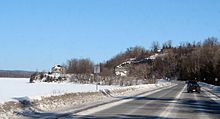 Regional Road 174 between Orleans and Cumberland.
The segment between the Highway 417 junction to Trim Road is a four-lane freeway with OC Transpo lanes in each direction from just east of Blair Road to Place d'Orleans. East of Trim Road, it becomes a two-lane rural highway until the Prescott-Russell County Line which is named Prescott-Russell Road 17 until the eastern end at Highway 417 east of Hawkesbury. Over the past years, traffic between Highway 417 and Rockland became much heavier due to suburban growth in Orléans and Rockland leading to frequent congestion during peak hours. Meanwhile, the eastern most portion of the road was regarded as dangerous due to several fatal accidents. In 2007, both provincial and federal government committed some fundings for the widening of Regional Road 174 between Trim Road and Rockland, although the widening construction project was still several years away. However, in April 2008, Ottawa City Council refused a $80 million funding for both provincial and federal governments citing it would not benefit to the City of Ottawa which would delay the construction indefinitely.[1][2]
History
Regional Road 174 was created on April 1, 1997 when the Ministry of Transportation of Ontario transferred the responsibility of maintenance and upkeep along 14.2 km (8.8 mi) of Highway 17 east of "the split" with Ontario Highway 417 to Trim Road (Regional Road 57), a process commonly referred to as downloading. Despite the protests of the city that the road served a provincial purpose, a second round of transfers saw Highway 17 east of Ottawa downloaded entirely on January 1, 1998 adding 12.8 km (8.0 mi) to the length of Regional Road 174. Ottawa immediately renumbered the transferred sections of Highway 17.[3]
See also
References
- ^ http://www.ottawa.ca/calendar/ottawa/citycouncil/trc/2008/04-16/ACS2008-PTE-PLA-0105.htm
- ^ CTV Ottawa
- ^ Department of Public Works and Services (September 14, 2004). Responsibilities and Obligations Re: Highway 174 (Report). City of Ottawa. http://www.ottawa.ca/calendar/ottawa/citycouncil/occ/2004/10-13/trc/ACS2004-CCS-TRC-0009.htm. Retrieved February 14, 2011.
Roads in Ottawa Provincial Highways Major Arteries 4th Line · Tenth Line · Airport · Albion · Bank · Baseline · Blair · Bronson · Carling · Carp · Cedarview · Conroy · Donnelly · Dwyer Hill · Eagleson · Elgin · Fallowfield · Greenbank · Hazeldean · Heron · Hunt Club · Innes · King Edward · March · Merivale · Mitch Owens · Moodie · Montreal · Parkdale · Prince of Wales · Regional Road 174 · Richmond · Rideau · River · Riverside · Robertson · St. Joseph · St. Laurent · Strandherd · Terry Fox · Vanier · Walkley · Wellington · WoodroffeCollectors/Secondary Arteries Albert · Alta Vista · Bankfield · Beechwood · Booth · Brookfield · Gladstone · Hawthorne · Hog's Back · Jockvale · Katimavik · Kent · Laurier · Lees · Leitrim · Main · Maitland · Meadowlands · Metcalfe · Nicholas · North Gower · O'Connor · Old Prescott · Osgoode Main · Pinecrest · Preston · Russell · Slater · Smyth · Somerset · Sparks · St. Patrick · Sussex · Tremblay · TrimFederal arteries Categories:- Roads in Ottawa
- Former segments of the Trans-Canada Highway


Wikimedia Foundation. 2010.