- Old Nichol
-
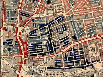 Part of Charles Booth's poverty map showing the Old Nichol in the East End of London. Published 1889 in Life and Labour of the People in London. The red areas are "middle class, well-to-do", light blue areas are “poor, 18s to 21s a week for a moderate family”, dark blue areas are “very poor, casual, chronic want”, and black areas are the "lowest class...occasional labourers, street sellers, loafers, criminals and semi-criminals".
The Old Nichol, also known as the Nichol or the Old Nichol Street Rookery, was an area of housing in the East End of London, between High Street, Shoreditch, and Hackney Road in the north, and Spitalfields in the south. The main streets within the Old Nichol were Boundary Street, Old Nichol Street, Half Nichol Street, The Mount and Church Street.[1] The slum was located in the western boundary of Bethnal Green, with six of its streets across Boundary Street located in Shoreditch.[2] The Old Nichol was home to 5,719 people, living in a dense network of about 30 streets and courts. The late 18th-century houses included workshops and stables.[3]
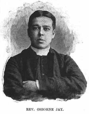
In Victorian Britain of the 1880s, the Old Nichol was London’s most notorious slum.[3] The “evil” reputation of the Old Nichol owed much to Arthur Morrison’s fictionalised account of it in A Child of the Jago (1896), and to sensational articles by Rev. Osborne Jay of Holy Trinity Church, known as Father Jay, on whom Morrison relied for information.[4]
Contents
Early history
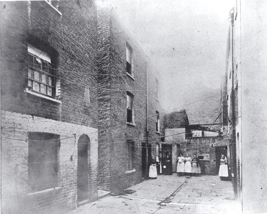
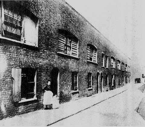
 Boundary Street in the Old Nichol, 1890.
 Boundary Street in the Old Nichol, 1890.
With the dissolution of the monasteries in the 1530s, the garden and fields on the land that became the Old Nichol passed into private hands. The Preston Gardens were created on what would later become the southernmost part of the Old Nichol, and the Swan Field would become Mount Street, today's Swansfield Street. Crock Lane, later Boundary Street and Church Street, was established in an L-shape, with narrow alleys running from it, established the original topographical characteristics of the Old Nichol. In the 1670s City of London merchants and lawyers started buying small freeholds behind St Leonard's, Shoreditch. The Gray's Inn lawyer John Nichol bought nearly five acres of land, bounded by the two arms of Cock Lane, on which he built seven houses. In 1680 he leased the land to Jon Richardson, a mason, who dug clay for brick-making during the London Restoration-era building boom, and then sublet his land to builders who constructed houses on the land. In the 1680s and 1690s Nichol Street, later Old Nichol Street, was developed, with Nichol Row being added in 1703, New Nichol Street between 1705 and 1708, and later Half Nichol Street.[5]
A high number of the 25,000 Protestant Huguenots who arrived from France in the late 1680s and 1690s and settled in Spitalfields and south Bethnal Green were silk weavers. This led to many houses in the north of the Old Nichol featuring "long lights", also known as weaver windows, so as to maximise daylight in the upper storey of the house where handloom weavers worked. Virginia Row, Virginia Road and (Old) Castle Street were built in the 1680s, while Mount Street and Rose Street existed by 1725. Until the 19th century, when the Old Nichol was established, the area between Mount Street, Rose Street and Half Nichol Street was fields. Late 17th-century housing was eventually demolished and speculative new building created Nelson, Vincent, Collingwood, Trafalgar, Mead, Christopher and Sarah Street, with numerous courts in between.[6] In the 1870s the street names in the north of the Old Nichol were changed in order to protect the memory of Admiral Nelson, in whose honour the streets had been named, from negative association with the slum.[7]
Housing stock
Many of the buildings in the Old Nichol contravened the Building Acts. Builders leasing land from owners who did not care what use was made of the acreage, so long as it was profitable, created an instant slum. The use of cheaper lime-based substances derived from the by-products of soap-making at local factories was the most important factor in the swift deterioration of the building fabric in the Old Nichol. Speculative builders used this cement, which was known as "Billysweet", instead of traditional lime mortar, and it quickly became infamous for never thoroughly drying out, leading to sagging and unstable walls. Other architectural features that contributed to urban decay in the Old Nichol included the lack of foundation of most early 19th century houses, which were built with floorboards laid on bare earth, cheap timber and half-baked bricks of ash-adulterated clay. The roofs were badly pitched, leading to rotting rafters and blooming plasterwork. The houses were permanently soggy, as damp from the roof and the earth seeped through the buildings. By 1836 the whole 15 acres (61,000 m2) of land which would form the Old Nichol had been built or rebuilt upon.[7]
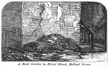 ”A back garden in Nichol Street, Bethnal Green” illustration for "More Revelations of Bethnal Green" in The Builder, vol. XXI, no. 1082 (31 October 1863)
Over the following fifteen years back yards and other open spaces were built upon with shanty-style developments, creating illegal courts, small houses, workshops, stables, cowsheds and donkey stalls. As surveyors and cartographers struggled to keep accurate maps of the Old Nichol, the already high population density increased further.[8] Families with more than one child often lied to be able to obtain a room and were thrown out if the rent collector or landlord found out that more than one child lived with family in one room. Monday was rent day, known as "Black Monday", and in the Old Nichol women would form queues outside the pawnshops with their belongings. The rent was collected by house agents who would evict tenants if the rent was in arrears.[9] In 1863 The Builder reported of the Old Nichol that:
"With few exceptions, each room contains a separate family; some consisting of mother, father, and eight children. The first two adjoining houses that we looked into, of six rooms each, contained forty-eight persons. To supply these with water, a stream runs for ten or twelve minutes each day, except Sunday, from a small tap at the back of one of the houses... The houses are, of course, ill-ventilated. The front room in the basement, wholly below the ground, dark and damp, is occupied, at a cost of 2s. a week for rent."[10]
On 24 October 1863 The Illustrated London News published an article entitled "Dwellings of the Poor in Bethnal-Green" which described the living conditions in the Old Nichol:
"This district of Friars-mount, which is nominally represented by Nichols-street, Old Nichols-street, and Half Nichols-street, including, perhaps most obviously, the greater part of the vice and debauchery of the district, and the limits of a single article would be insufficient to give any detailed description of even a day's visit. There is nothing picturesque in such misery; it is but one painful and monotonous round of vice, filth, and poverty, huddled in dark cellars, ruined garrets, bare and blackened rooms, teeming with disease and death, and without the means, even if there were the inclination, for the most ordinary observations of decency or cleanliness."[11]
The overcrowding in the Old Nichol was made worse as in the twenty years to 1887 various improvement projects were implemented. These included the widening and re-routing through slum streets of Bethnal Green Road in the late 1870s, at the southern edge of the Old Nichol, which made 800 people homeless, the creation of a large number of warehouses and factories in Shoreditch, the construction of three massive London School Board buildings within the Old Nichol, and in 1888/1889 a new church in Old Nichol Street required the eviction of 500 people.[12]
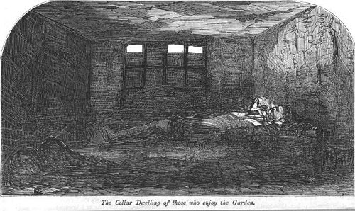
Some ten percent of the houses in Boundary Street had subterranean corridors in 1883, which the local medical officer regarded as one of the most alarming architectural phenomena of the Old Nichol housing stock. The only way to reach the back yard, in which the dustbins and the lavatory was located, was by descending rickety steps, passing through an unlit, unpaved cellar passageway just five feet high, with the yard at the other side. Cellars were illegally rented in the Old Nichol, though the law stated that underground living quarters had to have a window giving at least one foot of light at pavement level, a fireplace, drainage and head room of at least 7 ft (2.1 m).[13] On 31 October 1863 The Builder (vol. XXI, no. 1082) published an article "More Revelations of Bethnal Green", describing the underground rooms of the Old Nichol:
"The occupation of the underground rooms here, as well as elsewhere, is illegal, and may at once be prevented. Under the Local Management Act, as our readers may remember, an underground room may not be occupied separately as a dwelling unless certain conditions are complied with, one of which is that there shall be a window of specified size, with an area before it open down to 6 inches below the floor of the room... One of the worst examples that we saw of these underground rooms we must endeavour to illustrate. It is in Nichol-street, No.59, and may be described as entirely below the surface. the window of the apartment is a little over 3 feet in width, and about the same in height; the area is even with the breadth and depth of the window. It extends from the wall about 2 feet, and was closed with an iron grating; but this having become broken, the entire top of the area has been covered with wood, so that the only means of light and ventilation is a chink 3 feet wide by 4 and a half inches in height. Passing through the passage to the back, the dilapidated condition of the premises, as may be seen in the sketch, is startling. The plaster has fallen from the walls and the ceilings, the narrow staircase is rotten and shaky, the general colour is of a dingy smoky black, with peeps of indifferent brickwork and broken laths. At the back there is a large open space, in a most filthy condition; damp refuse of all kinds is piled up against the wall; there is no supply of water;"[10]
Inhabitants
 "A Cellar dwelling in Nichol Street", illustration for "More Revelations of Bethnal Green", published in The Builder, vol. XXI, no. 1082 (31 October 1863)
The Old Nichol was a Cockney enclave, with second and third generation Londoners formed the majority of inhabitants of the slum. Over a third of London's four million inhabitants had been born outside the city, but this figure dipped to an eighth in the Old Nichol, the lowest figure for any part of London. The Old Nichol, like the 129,000 inhabitants of Bethnal Green, was in the late 1880s largely homogenous. Although there was a significant number of settled and half settled Irish gypsy, known as "didicai", and Romany families, and judging from the surnames, descendants of Huguenot settlers.[12] The rotten housing stock of the Old Nichol was the only type of property the very poorest could afford. The surviving Poor Law case histories for the area show that the Old Nichol was for many East End Londoners the final stop before entering into workhouses.[14]
Trades and work
The Old Nichol was locally known as "The Sweaters' Hell", in references to the prevalence of home-based artisan work that paid little among Old Nichol inhabitants. Work was plentiful, but pay was poor and wages got lower. Hundreds of Old Nichol inhabitants made couches, chairs, mirrors and toys, or worked as sawyers, carvers, french polishers, ivory turners and upholsterers, with their tiny homes doubling as workshops. The Old Nichol had several timber yards and on weekdays the streets of the Old Nichol saw carts and barrows carry newly sawn planks and freshly turned furniture components. Finished tables, chairs and wardrobes were sold to the local wholesaler.[13] Close to the Old Nichol were Shoreditch's Curtain Road furniture depots and wholesale emporia. The proximity to the London Docks, which required vast amounts of casual, ill-paid labour, made the Old Nichol home to low-paid labourers. Street sellers also lived in the Old Nichol, which was ideally situated just outside the City of London boundaries, a 15-minute walk from Liverpool Street station and a 25-minute walk from the Bank, Mansion House, and Guildhall.[15]
In 1863 an article in The Illustrated London News described the living and working conditions in the Old Nichol:
"In the neighbourhoods where the inhabitants follow poor trades the condition is but little better: a few streets where there is a more cleanly appearance do but lead to a repetition of the horrors just witnessed; and from garret to cellar whole families occupy single rooms, or, if they can find a corner of available space, take a lodger or two. In some wretched cul de sac, partly inhabited by costers, the fetid yards are devoted to the donkeys, while fish are cured and dried in places which cannot be mentioned without loathing. Bandbox and lucifer-box makers, cane workers, clothespeg makers, shoemakers, and tailors, mostly earning only just enough to keep them from absolute starvation, swarm from roof to basement; and, as the owners of such houses have frequently bought the leases cheaply and spend nothing for repairs, the profits to the landlords are greater in proportion than those on a middle-class dwelling."[11]
Health
Whooping cough, which killed more children under the age of five than any other transmittable illness, scarlet fever, diphtheria, measles, smallpox, bronchitis and especially tuberculosis had a fatality rate in the Nichol that was twice as high as that in Bethnal Green, at that time a very poor East London parish. While the contagion rate in the Old Nichol was not higher than in Bethnal Green, inhabitants of the Old Nichol were less likely to recover. Contemporary medical thinking linked the health statistics of the Old Nichol to the overcrowding, lack of sanitary fittings, pervasive damp, lack of light and fresh air.[16]
In the late 1880s the annual mortality rate in the Old Nichol was 40 per 1,000 people, with Bethnal Green's being between 22 and 23 per 1,000 people, and the national average being 19 to 20 per 1,000 people. Four-fifths of the around 5,700 inhabitants of the Old Nichol were children[13] and the death rate of babies under the age of one was 252 per 1,000 live births, compared to Bethnal Green's death rate of 150 per 1,000 live births, which was in line with average death rates in England and Wales.[16] It 1887 the coroner in Bethnal Green reported that around five out of six infant deaths investigated by the coroner were found to be suffocation cases in one-room homes where the entire family had slept in one bed. The cause of deaths was described as "overlaying", with a sleeping parent or older child rolling on top of the infant and accidentally killing them. The press at the time noted that such deaths were more common on Friday, Saturday and Sunday nights, suggesting that heavy drinking was a factor in the fatalities.[13]
Owners and management
Almost half of the properties in the Old Nichol were managed by solicitors and other trustees to benefit estates of the long deceased. Two of the largest Old Nichol holdings, the Gwatkin Estate and the Wolley Estate, including about 297 houses, were managed partly on behalf of phantoms. Several of the Old Nichol estates were the subject of long-running Court of Chancery cases. While there were rumours that the owners of the freeholds and leaseholds included peers of the realm, churchmen, Bethnal Green vestrymen and several dead people. One investigation into the housing conditions in the Old Nichol at the time found that many tenants had huge difficulties finding out who their landlords really were:
"Their rent books contain only the names of the tenants, the amounts and the dates of payment, and the initials of the rent collector... The collectors are often merely agents' clerks. Sometimes the persons for whom the collectors act are only farmers of the rent; and they not only bully the tenants, but often take the law into their own hands, and turn the people into the street without legal warrant of any kind.[16]
A single house could have several interested parties, with the ground landlord or freeholder, being unaware of the actions of his or her leaseholder. Leaseholders would frequently lease out various parts of a house, while the weekly tenants sublet to lodgers, who sometimes sublet to other lodgers. Per cubic foot the rents in the Old Nichol were four to ten times higher than those of the finer streets of the London West End, averaging between 2s 3d to 3s for a single room and around 7s 6d for a three-room lodging. This provided high profits to speculative property dealers, which a housing reform campaigner of the time called "the vampyres of the poor".[16] Many of the properties in the Old Nichol were held on fast-expiring leases, and leaseholders thought to get to the end of the lease without spending any money on maintenance or improvements.[13]
Richard Temple-Nugent-Brydges-Chandos-Grenville, 1st Duke of Buckingham and Chandos, owned a plantation in Jamaica and 10,482 acres (42.42 km2) in Britain, including thirty-eight properties in the Old Nichol. With the help of a solicitor and lease holder his heiress Lady Mary Morgan-Grenville, Baroness Kinloss, remained unknown to the public until 1892, when she broke cover to collect her compulsory purchase compensation for the houses. Another owner of houses in the Old Nichol was Sir Edward Colebrooke, 1st Baron Colebrooke who was Lord High Commissioner to the General Assembly of the Church of Scotland and owned 30,000 acres (120 km2) across Britain.[17]
 Reverend Osborne Jay of Holy Trinity Church, known as Father Jay in the Old Nichol
Joseph Jacobs, head of the Bethnal Green Vestry Sanitary Committee ran one of the most lucrative pubs in the Old Nichol, The Victory at 65 Nelson Street, for forty years.[18] Watson Francis, chairman of the Bethnal Green Vestry and member of the local Board of Guardians of the Poor, owned houses in the Old Nichol; a sanitary inspection found him renting a small underground room close to a lavatory to a pie maker, who prepared his pies in the room. Henry Quaitrell, Bethnal Green vestryman and member of the Sanitary Committee, by trade a builder, rented out a large number of Old Nichol houses. Similarly the vestryman and Sanitary Committee member William Museum Burrows owned two houses on Mead Street that were found to be insanitary. Between 1865 and 1885 Burrows had been the Bethnal Green Inspector of Nuisances, but had failed to self-inspect. The largest slumlord of the Old Nichol with a seat at the Bethnal Green vestry was the hardware store and plumbing supplies merchant Henry Collins Gould. He held a forty-two houses lease from the large Gwatkin Estate, and the lease on 107 Mount Street, which had been declared a "dangerous structure" by the parish surveyor. Gould was served with a notice for the unsanitary conditions in 51 Mount Street and was fined for the conditions in 3 and 49 Mount Street. Gould also received a closure notice for 7 and 9 Christopher Place in June 1886, the same month in which Gould disobeyed magistrates' orders by neglecting to lay water to the lavatories at his six houses in Jacob Street.[13] Property owned or leased by Gould, Burrows and Quaintrell were on the 1,601 strong list of insanitary property compiled by the Mansion House Council in June 1886, forcing all three vestrymen to remedy the situation.[13]
The Old Nichol in Victorian slum fiction
The Old Nichol inspired a number of slum fiction novels. The “evil” reputation of the Old Nichol owed a lot to Arthur Morrison’s fictionalised account of it in A Child of the Jago, and to sensational articles by Reverend Osborne Jay of Holy Trinity Church, known as Father Jay, on whom Morrison relied for information.[4] The novel became so popular that the "Jago" became an interchangeable name for the Old Nichol.[19] Father Jay also appeared as "Father Ranald" in L. T. Meade's 1895 novel Princes of the Gutter, with the "gutter" being the Old Nichol.[13]
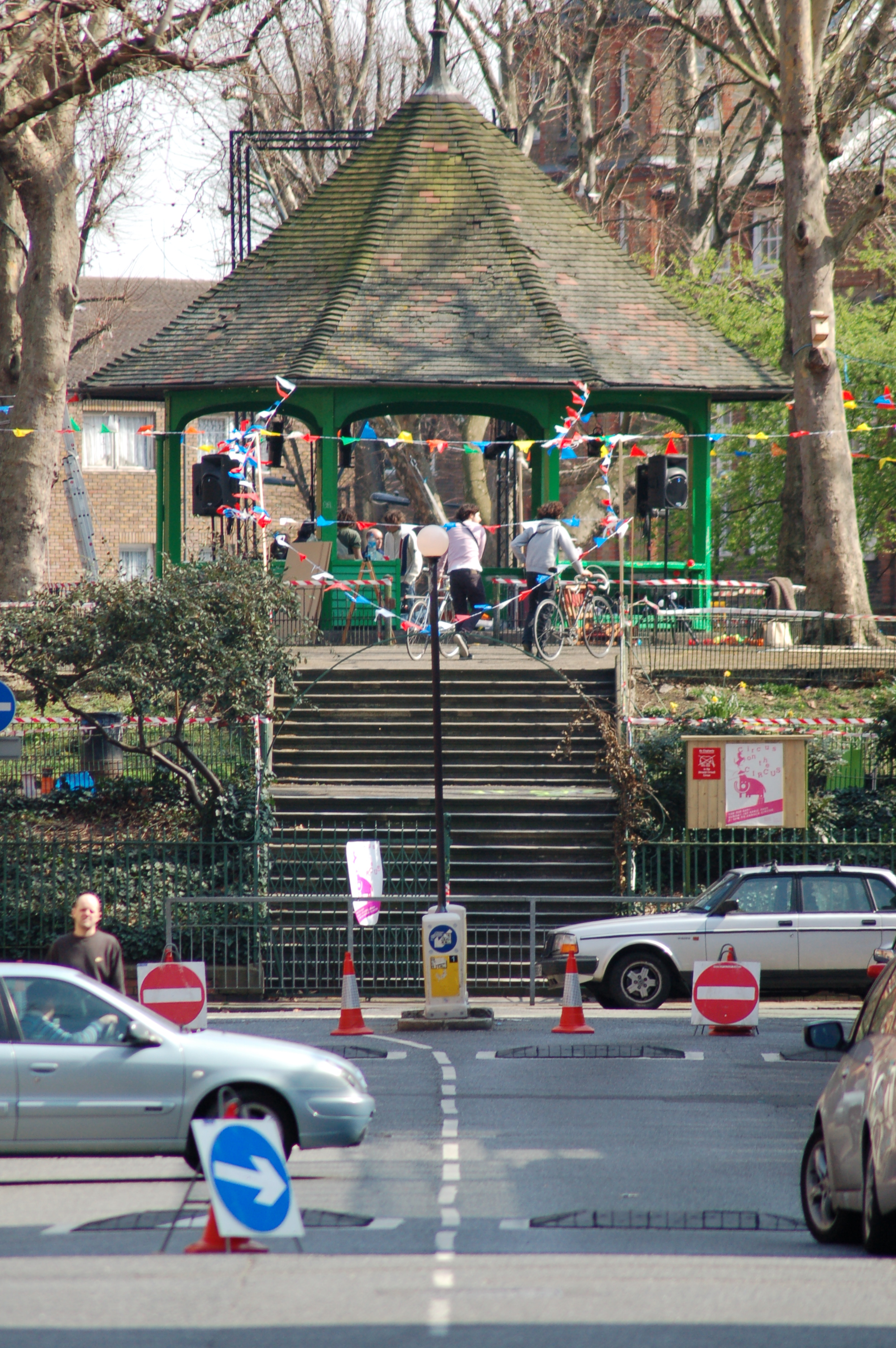
 The Boundary Estate bandstand at Arnold Circus, built with the rubble of the Old Nichol slum, is the centrepiece of the estate
Slum clearance
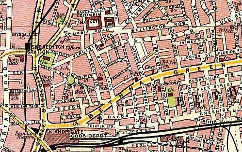
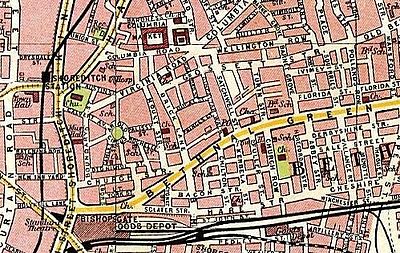 1908 map of the Old Nichol area, after the slum clearance, showing Arnold Circus
After Old Nichol house owners were required under the Torrens Act to repair and render the houses "tolerably comfortable" a government enquiry of 1887 found the Old Nichol to be in "fair condition" but in 1890 the Old Nichol was declared a slum. The newly established London County Council (LCC) decided to rebuild an area of some 15-acre (61,000 m2), including the Nichol and Snow estates, and a small piece on the Shoreditch side of Boundary Street, formally Cock Lane. The slum clearance began in 1891 and included 730 houses inhabited by 5,719 people. Owen Fleming, who designed the Boundary Street scheme for the Old Nichol, retained only Boundary Street in the west and Mount Street in the east, though he widened both to 40 ft (12 m). Old Nichol Street was also widened and extended to Mount Street, then renamed Calvin Street. He designed 50 ft (15 m). wide streets to radiate from an ornamental space called Arnold Circus. The LCC architects designed 21 and Rowland Plumbe two of 23 blocks containing between 10 and 85 tenements each. A total of 1,069 tenements, mostly two or three-roomed, were planned to accommodate 5,524 persons. The project was hailed as setting "new aesthetic standards for housing the working classes" and included a new laundry, 188 shops, and 77 workshops. Churches and schools were preserved. Building for the project began in 1893 and it was opened by the Prince of Wales in 1900. The tenants of the new blocks were, with few exceptions, not the original inhabitants of the Old Nichol. The need for small houses had been ignored and many Old Nichol inhabitants could not afford even the new rent of 3s. a room. The new blocks had policies to enforce sobriety and the new tenants were clerks, policemen, cigarmakers and nurses. The Old Nichol inhabitants moved into old houses nearby, spreading eastward of the Nichol.[20]
See also
- Beer Street and Gin Lane
- Boundary Estate
- Denmark Street
- Devil's Acre
- Flower and Dean Street
- Lisson Grove
- Matthew Hay
- Rookery
- Somers Town, London
- Spitalfields rookery
- Wych Street
References
- ^ Carstairs, Jonathan. "The Life of Arthur Harding - The Nichol". Bishopsgate Institute. http://www.bishopsgate.org.uk/content.asp?CategoryID=1198. Retrieved 22 May 2010.
- ^ Wise, Sarah (June 2009). the Blackest Streets: The Life and Death of a Victorian Slum. Vintage. p. 8. ISBN 978-1844133314.
- ^ a b "The Blackest Streets: The Life and Death of a Victorian Slum by Sarah Wise". The Sunday Times. 22 June 2008. http://entertainment.timesonline.co.uk/tol/arts_and_entertainment/books/book_reviews/article4164526.ece. Retrieved 22 May 2010.
- ^ a b Jenks, Chris (2004). Urban culture: critical concepts in literary and cultural studies. Volume 4. Taylor & Francis. p. 99. ISBN 9780415304993. http://books.google.co.uk/books?id=MOnT2LUWV10C&dq=A+Child+of+the+Jago+nichol&source=gbs_navlinks_s.
- ^ Wise, Blackest Streets, p. 14
- ^ Wise, Blackest Streets, p. 15
- ^ a b Wise, Blackest Streets, p. 16
- ^ Wise, Blackest Streets, p. 17
- ^ Wise, Blackest Streets, p. 74
- ^ a b "More Revelations of Bethnal Green". The Builder. 31 October 1863. http://www.mernick.org.uk//thhol/morevbg.html. Retrieved 22 May 2010.
- ^ a b Dwellings of the Poor in Bethnal-Green. The Illustrated London News. 24 October 1863. http://www.mernick.org.uk//thhol/dwelpoor.html. Retrieved 22 May 2010.
- ^ a b Wise, Blackest Streets, p. 11
- ^ a b c d e f g h Wise, Blackest Streets, p. 27
- ^ Wise, Blackest Streets, p. 10
- ^ Wise, Blackest Streets, pp. 10–11
- ^ a b c d Wise, Blackest Streets, p. 9
- ^ Wise, Blackest Streets, p. 51
- ^ Wise, Blackest Streets, p. 35
- ^ Jenks, Urban culture, Vol 4, p. 226
- ^ Baker, TFT (1998). "A History of the County of Middlesex: Volume 11: Stepney, Bethnal Green". British History Online. http://www.british-history.ac.uk/report.aspx?compid=22752. Retrieved 23 May 2010.
Categories:- Geography of Tower Hamlets
- History of Tower Hamlets
- Geography of Hackney
- History of Hackney
- Poverty
- Former slums of London

Wikimedia Foundation. 2010.