- Mullewa, Western Australia
-
Mullewa
Western AustraliaPopulation: 425[1] Established: 1894 Postcode: 6630 Elevation: 281 m (922 ft) [2] Location: - 450 km (280 mi) N of Perth
- 98 km (61 mi) ENE of Geraldton
LGA: City of Greater Geraldton State District: Moore Federal Division: Durack Coordinates: 28°32′13″S 115°30′43″E / 28.537°S 115.512°E
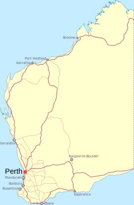
Mullewa is a town in the Mid West region of Western Australia, 450 kilometres (280 mi) north of Perth and 98 kilometres (61 mi) east-northeast of Geraldton.
Contents
History
European settlers moved to the area in 1869 to take up pastoral leases for farming.[3] In 1894, the government built a narrow gauge railway from Geraldton to Mullewa and the town was gazetted in the same year.[3] The town is named for Mullewa Spring, based on an Aboriginal name recorded by surveyor John Forrest in 1873.[3] The meaning of the name is not certain, but the most accepted meaning is "place of fog".[3]
The Church of Our Lady of Mount Carmel in Mullewa was designed and built by Monsignor John Hawes.
Rail service
One of the Western Australian Government Railways named overnight passenger services from Perth was known as The Mullewa, which ceased operation in 1974. Mullewa is the junction of the railway line northeast to Meekatharra, and south to Northam.[4]
Iron ore is hauled by road 65 km from Tallering Peak, and loaded onto railway wagons for haulage 107 km to Geraldton where ships of up to 60,000 DWT are loaded.
Climate
Mullewa has a semi-arid climate with hot summers and mild to cool winters. The town features a dry summer/wetter winter routine, thus giving its climate some characteristics of the Mediterranean one.
Climate data for Mullewa Month Jan Feb Mar Apr May Jun Jul Aug Sep Oct Nov Dec Year Record high °C (°F) 47.3
(117.1)46.5
(115.7)44.0
(111.2)41.7
(107.1)35.5
(95.9)29.4
(84.9)28.9
(84.0)33.0
(91.4)37.6
(99.7)40.4
(104.7)43.2
(109.8)45.0
(113.0)47.3
(117.1)Average high °C (°F) 36.8
(98.2)36.4
(97.5)33.7
(92.7)28.7
(83.7)23.7
(74.7)19.9
(67.8)18.7
(65.7)20.1
(68.2)23.4
(74.1)27.1
(80.8)31.1
(88.0)34.4
(93.9)27.8 Average low °C (°F) 19.4
(66.9)20.0
(68.0)18.3
(64.9)15.0
(59.0)11.1
(52.0)8.5
(47.3)6.9
(44.4)7.0
(44.6)8.5
(47.3)11.0
(51.8)14.3
(57.7)16.9
(62.4)13.1 Record low °C (°F) 9.0
(48.2)10.0
(50.0)7.4
(45.3)5.0
(41.0)1.4
(34.5)−0.3
(31.5)−1.2
(29.8)−1.4
(29.5)0.0
(32.0)2.8
(37.0)6.0
(42.8)7.2
(45.0)−1.4
(29.5)Precipitation mm (inches) 13.1
(0.516)18.6
(0.732)18.8
(0.74)21.2
(0.835)47.2
(1.858)64.6
(2.543)60.4
(2.378)42.2
(1.661)21.7
(0.854)13.0
(0.512)8.7
(0.343)8.5
(0.335)339.0
(13.346)Avg. precipitation days 2.3 2.4 2.5 3.8 7.1 10.3 11.2 9.6 6.1 4.1 2.3 1.9 63.6 Source: [5] References
- ^ Australian Bureau of Statistics (25 October 2007). "Mullewa (L) (Urban Centre/Locality)". 2006 Census QuickStats. http://www.censusdata.abs.gov.au/ABSNavigation/prenav/LocationSearch?collection=Census&period=2006&areacode=UCL519600&producttype=QuickStats&breadcrumb=PL&action=401. Retrieved 2008-05-07.
- ^ http://www.altitude.nu/ Elevation at any place.
- ^ a b c d Western Australian Land Information Authority. "History of country town names". http://www.landgate.wa.gov.au/corporate.nsf/web/History+of+country+town+names. Retrieved 2008-05-07.
- ^ "The Demise of Mullewa as a Rail Centre" Milne, Rod Australian Railway Historical Society Bulletin, November, 1992 pp255-270
- ^ "Climate statistics for Mullewa". Bureau of Meteorology. http://www.bom.gov.au/climate/averages/tables/cw_008095_All.shtml. Retrieved 15 October 2011.
External links
Towns in the Mid West region of Western Australia Abbotts · Ajana · Alma · Arrino · Arrowsmith · Austin · Big Bell · Binnu · Boogardie · Bowgada · Bunjil · Canna · Cape Burney · Carnamah · Caron · Coorow · Cuddingwarra · Cue · Day Dawn · Dongara · Drummond Cove · East Bowes · Eneabba · Eradu · Gabanintha · Green Head · Greenough · Gunyidi · Gutha · Horseshoe · Horrocks · Howatharra · Isseka · Kalbarri · Kojarena · Koolanooka · Kumarina · Latham · Leeman · Lennonville · Lynton · Mainland · Marchagee · Maya · Meekatharra · Merkanooka · Mingenew · Minnenooka · Moonyoonooka · Morawa · Mount Erin · Mount Magnet · Mullewa · Nabawa · Nangetty · Nannine · Nanson · Naraling · Narngulu · Narra Tarra · Northampton · Oakajee · Ogilvie · Paynes Find · Peak Hill · Paynesville · Perenjori · Pindar · Pintharuka · Porlell · Port Denison · Port Gregory · Protheroe · Reedy · Rothsay · Sandstone · Tardun · Tenindewa · Three Springs · Tuckanarra · Waggrakine · Walkaway · Warriedar · Whelarra · Wicherina · Wiluna · Winchester · Yalgoo · Yandanooka · Youanmi · Yoweragabbie · Yuna
Categories:- Towns in Western Australia
- Australian Aboriginal placenames
- Mid West (Western Australia)
Wikimedia Foundation. 2010.

