- Greenough, Western Australia
Infobox Australian Place | type = town
name = Greenough
state = wa
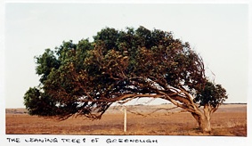
caption = A Leaning Tree of Greenough
lga =Shire of Greenough
postcode = 6532
est =
pop = 832 (2006 Census) [Census 2006 AUS|id=SSC54041|name=Greenough (State Suburb)|quick=on|accessdate=2008-09-20]
elevation= 21
maxtemp =
mintemp =
rainfall =
stategov = Greenough
fedgov = O'Connor
dist1 = 403
dir1 = NW
location1= Perth
dist2 = 22
dir2 = SE
location2= Geraldton
dist3 = 40
dir3 = NW
location3= DongaraGreenough is a historical town located 400 kilometres north of
Perth, Western Australia and 24 kilometres south of Geraldton on theBrand Highway . The historic buildings are controlled by theNational Trust of Australia . Another feature popular with tourists are the trees that are bent 90 degrees due to the coastal winds.The mouth of the
Greenough River is about 10 km to the north of the town.On 16 February 1999, a rare annular
solar eclipse of magnitude 0.9906 was visible from the area. [cite web|url=http://www.uq.net.au/~zzpeande/eclfeb99.htm|title=The 16 February 1999 Annular Solar Eclipse|year=1999|accessdate=2008-09-20]History
The area was first explored by George Grey in 1839 after which he named the area after Sir
George Bellas Greenough , the president of theRoyal Geographical Society inLondon . Grey claimed that the area could become "the granary of Western Australia". [LandInfo WA|c|G|2008-09-20]In 1851
Augustus Gregory surveyed 30,000 acres (120 km²) of land in the region which became known as the Greenough Flats. This was subdivided into 20- and 30-acre lots with the view to encouraging English settlers who would be more used to the relatively small (by Australian standards) farm sizes. Within a few years it had developed into a highly successfulwheat growing area and a population of over 1,000 from which a successful town developed.A series of disasters starting with a major cyclone in 1872 and major flooding in 1888 as well as the discovery of gold in the goldfields caused the gradual decline and abandonment of the settlement so that by 1900 most of the settlers had left the area with many of the small farmlets converted to grazing. The town fell into disrepair until a tourism-based project in the 1980s helped refurbish many of the buildings.
In 1993, a woman and her three young children were brutally murdered in this small town. This tragic event featured on the Australian television show "
Crime Investigation Australia " and is now infamously known as theGreenough Family Massacre . [cite web|url=http://www.westaustralianvista.com/history-of-greenough.html|title=West Australian Vista - History of Greenough|year=2008|accessdate=2008-09-20]References
Wikimedia Foundation. 2010.