- U.S. Route 75 Alternate (Beggs–Sapulpa, Oklahoma)
-
U.S. Route 75 Alternate

Route information Maintained by ODOT Length: 30.15 mi[2][3] (48.52 km) Existed: August 28, 1959[1] – present Major junctions South end: 
 US-75 / SH-16 east of Beggs
North end:  I-44 in Sapulpa (concurrent with SH-66)
Highway system United States Numbered Highways
List • Bannered • Divided • ReplacedU.S. 75 Alternate (also signed as U.S. Highway 75A or State Highway 75A) is a 30.15-mile (48.52 km) highway near Tulsa. The southern terminus is at U.S. Highway 75 and SH-16 east of Beggs. The northern terminus is signed at State Highway 66 and State Highway 97 in Sapulpa. However, the highway continues unsigned along SH-66, ending at the north terminus of the Turner Turnpike, where SH-66 merges onto the free portion of I-44. It runs parallel to US-75 for its entire length.
US-75 ALT follows the route of US-75 prior to the construction of the Okmulgee Beeline and its subsequent designation as US-75 in 1959.
Contents
Route description
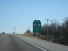 Signage for ALT US-75 and SH-16 at the former's southern terminus along US-75.
US-75 Alternate begins where SH-16 crosses US-75 east of Beggs. West of this intersection, US-75 ALT is signed along with SH-16. The two highways continue west into the city of Beggs, where the partnership ends. US-75 ALT turns north, passing through Beggs, and after leaving the city, rural areas of Okmulgee County on a due north course. The highway crosses into Creek County, then curves to the northeast for about 1 mile (1.6 km) before returning to a northerly course through Mounds.[4] After passing through Mounds, US-75 ALT follows a route a few degrees west of due north, bringing it to the town of Kiefer, where it serves as the western terminus of SH-67.
From Kiefer, the highway turns northwest. The highway bridges Polecat Creek as it turns west to enter the city of Sapulpa.[4] The route then turns back to the north as it gets closer the city's core. The highway intersects SH-117 in about the center of town. The road then intersects SH-33 and SH-66, while the mainline becomes SH-97. At this intersection, signage indicating the north end of US-75 ALT is posted.
Officially, however, US-75 ALT continues onward from here, turning right and following SH-66 through the east part of Sapulpa. This section of US-75 ALT is signed exclusively as SH-66. The road parallels I-44, the Turner Turnpike. The highways pass under the Creek Turnpike as well. Finally, as the Turner Turnpike comes to an end and I-44 transitions into a free Interstate, SH-66 merges onto the freeway. US-75 ALT ends at this point, just south of the Creek–Tulsa County line.
History
US-75 ALT was the route of US-75 before the "Okmulgee Beeline", the expressway/freeway between Preston and Tulsa, was built. On August 28, 1959, US-75 was moved onto the new highway, and US-75 ALT was designated in its place.[1]
Junction list
County Location Mile[5] Destinations Notes Okmulgee 0.00 US-75 / SH-16Southern terminus, SH-16 joins northbound and continues east past southbound terminus Beggs 3.6 SH-16SH-16 splits northbound and joins southbound Creek Kiefer 18.0  SH-67
SH-67Western terminus of SH-67 Sapulpa 22.8  SH-117
23.5 

 SH-33 / SH-66 / SH-97
Signed northern terminus of US-75 ALT, southern terminus of SH-97, eastern terminus of SH-33  SH-117A
Northern terminus of SH-117A 30.15 I-44 / SH-66Northern terminus of US-75 ALT 1.000 mi = 1.609 km; 1.000 km = 0.621 mi References
- ^ a b Oklahoma Department of Transportation. "Memorial Dedication and Revision History, US 75". http://www.okladot.state.ok.us/memorial/legal/us75.htm. Retrieved 2010-03-04.
- ^ Oklahoma Department of Transportation. 2008 Control Section Maps (Map). p. Okmulgee. http://www.odot.org/hqdiv/p-r-div/maps/control-maps/okmulgee.pdf. Retrieved 2010-03-04.
- ^ Oklahoma Department of Transportation. 2008 Control Section Maps (Map). p. Creek. http://www.odot.org/hqdiv/p-r-div/maps/control-maps/creek.pdf. Retrieved 2010-03-04.
- ^ a b DeLorme (2006). Oklahoma Atlas and Gazetteer (Map). 1:200,000.
- ^ Stuve, Eric. "OK-75a". OKHighways. http://www.okhighways.com/ok75a.html. Retrieved 2010-03-04.
External links
Categories:- U.S. Highways in Oklahoma
- Bannered and suffixed U.S. Highways


Wikimedia Foundation. 2010.