- Nyuksensky District
-
Nyuksensky District (English)
Нюксенский район (Russian)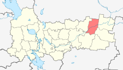
Location of Nyuksensky District on the map of Vologda OblastCoordinates: 60°25′N 44°14′E / 60.417°N 44.233°ECoordinates: 60°25′N 44°14′E / 60.417°N 44.233°E 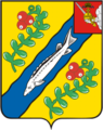
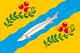
Coat of Arms of Nyuksensky District Flag of Nyuksensky District Administrative status Country Russia Federal subject Vologda Oblast[1] Administrative center selo of Nyuksenitsa[2] # of cities/towns 0[2] # of urban-type settlements 0[2] # of selsoviets 11[2] Municipal status (as of May 2010) Municipally incorporated as Nyuksensky Municipal District[3] - # of urban settlements 0[3] - # of rural settlements 4[3] Statistics Area 5,167 km2 (1,995 sq mi)[4] Population (2010 Census,
preliminary)9,787 inhabitants[5] Population (2002 Census) 11,714 inhabitants[6] - Urban population 0% - Rural population 100% Density 2 /km2 (5.2 /sq mi)[7] Time zone MSD (UTC+04:00)[8] Established June 10, 1924[9] District newspaper Новый День (Novy Den, New Day)[10] Official website Nyuksensky District (Russian: Нюксенский район) is an administrative district (raion), one of the twenty-six in Vologda Oblast, Russia.[1] Municipally, it is incorporated as Nyuksensky Municipal District.[3] It is located in the northeast of the oblast and borders with Ustyansky District of Arkhangelsk Oblast in the north, Velikoustyugsky District in the east, Kichmengsko-Gorodetsky District in the southeast, Babushkinsky District in the south, Totemsky District in the southwest, and Tarnogsky District in the west. The area of the district is 5,167 square kilometers (1,995 sq mi). Its administrative center is the rural locality (a selo) of Nyuksenitsa.[2] District's population: 9,787 (2010 Census preliminary results);[5] 11,714 (2002 Census);[6] 13,287 (1989 Census).[11] Population of Nyuksenitsa accounts for 37.6% of the district's population.[6]
Contents
History
The area was originally populated by the Finno-Ugric peoples and then colonized by the Novgorod Republic (Totma) and Vladimir-Suzdal Principality (Veliky Ustyug). The Novgorod merchants used the Sukhona River as one of the main waterways leading to the White Sea and the Pechora. After the fall of Novgorod, the area became a part of the Grand Duchy of Moscow. The village of Bobrovy Yam (currently Bobrovskoye) has been mentioned in the chronicles in 1425.[4] Nyuksenitsa has been first mentioned in 1619.[12]
In the course of the administrative reform carried out in 1708 by Peter the Great the area was included into Archangelgorod Governorate. In 1780, the governorate was abolished, and transformed into Vologda Viceroyalty. The latter was abolished in 1796, and the part of it which included Nyuksenitsa was made Vologda Governorate. It was included into Velikoustyugsky Uyezd. In 1918, the area was transferred to the newly established Northern Dvina Governorate, and in 1924 the uyezds were abolished in favor of the new divisions, the districts (raions).
Nyuksensky District was established on June 10, 1924 and included areas of former Solvychegodsky and Velikoustyugsky Uyezds. On February 27, 1928, it was renamed into Sukhonsky District. In 1929, Northern Dvina Governorate was merged into Northern Krai, and Kokshengsky District was established. On July 30, 1931 Sukhonsky and Kokshengsky Districts were merged, and Nyuksensky District was re-established, with the administrative center located in Nyuksenitsa. In 1935, Tarnogsky District split off from the Nyuksensky District.[9] In 1936, Northern Krai was transformed into Northern Oblast, and in 1937, Northern Oblast was split into Arkhangelsk Oblast and Vologda Oblast. Nyuksensky District remained in Vologda Oblast ever since.
Location and geography
The district is located at both banks of the Sukhona River. Is is elongated from north to south and crossed by the Sukhona roughly into two equal parts. The major part of the district belongs to the rive basin of the Sukhona and two of its tributaries, the Uftyuga (left) and the Gorodishna (right). The north of the district drains into the Ustya River basin and thus into the basin of the Vaga, a major tributary of the Northern Dvina. Some areas in the south-east of the district drain into the Kichmenga and the Sharzhenga, left tributaries of the Yug River. The whole district belongs to the river basin of the Northern Dvina.
Almost the whole of the district is covered by coniferous forests (taiga). The exception are the meadows in the floodplains.
Economy
Industry
The economy of the district is based on timber production. There is some food industry present, including a milk factory in Nyuksenitsa.[10]
Agriculture
There is cattle farming in the district, which is still in crisis after the fall in 1990s.[10] All agricultural areas in the district occupy 313 square kilometres (121 sq mi). Another 5,106 square kilometres (1,971 sq mi) are hunting grounds.[4]
Transport
Nyuksenitsa is on the road connecting Vologda and Veliky Ustyug, and in Nyuksenitsa the road moves over the bridge from the left bank to the right bank of the Sukhona. Another paved road branches off in Nyuksenitsa northwest to Tarnogsky Gorodok and further to Oktyabrsky in Arkhangelsk Oblast. There is regular passenger bus service on both roads.
The Sukhona is navigable within the district, however, there is no passenger navigation.
Nyuksenitsa has an oil-pumping station in the Baltic Pipeline System.[10]
Culture and recreation
The district contains 130 objects classified as cultural and historical heritage of local importance.[13] Most of these are wooden farms and churches built prior to 1917.
The only state museum in the district is the Nyuksenitsa Regional Museum, located in Nyuksenitsa.[14]
References
Notes
- ^ a b Law #371-OZ
- ^ a b c Resolution #178
- ^ a b c Law #1120-OZ
- ^ a b c "Паспорт Нюксенского муниципального района" (in Russian). Администрация Нюксенского муниципального района. http://nux.ucoz.ru/index/0-2. Retrieved 31 August 2011.
- ^ a b Федеральная служба государственной статистики (Federal State Statistics Service) (2011). "Предварительные итоги Всероссийской переписи населения 2010 года (Preliminary results of the 2010 All-Russian Population Census)" (in Russian). Всероссийская перепись населения 2010 года (All-Russia Population Census of 2010). Federal State Statistics Service. http://www.perepis-2010.ru/results_of_the_census/results-inform.php. Retrieved 2011-04-25.
- ^ a b c Федеральная служба государственной статистики (Federal State Statistics Service) (2004-05-21). "Численность населения России, субъектов Российской Федерации в составе федеральных округов, районов, городских поселений, сельских населённых пунктов – районных центров и сельских населённых пунктов с населением 3 тысячи и более человек (Population of Russia, its federal districts, federal subjects, districts, urban localities, rural localities—administrative centers, and rural localities with population of over 3,000)" (in Russian). Всероссийская перепись населения 2002 года (All-Russia Population Census of 2002). Federal State Statistics Service. http://www.perepis2002.ru/ct/doc/1_TOM_01_04.xls. Retrieved 2010-03-23.
- ^ The value of density was calculated automatically by dividing the 2010 Census population by the area specified in the infobox. Please note that this value may not be accurate as the area specified in the infobox does not necessarily correspond to the area of the entity proper or is reported for the same year as the population.
- ^ Правительство Российской Федерации. Постановление №725 от 31 августа 2011 г. «О составе территорий, образующих каждую часовую зону, и порядке исчисления времени в часовых зонах, а также о признании утратившими силу отдельных Постановлений Правительства Российской Федерации». Вступил в силу по истечении 7 дней после дня официального опубликования. Опубликован: "Российская Газета", №197, 6 сентября 2011 г. (Government of the Russian Federation. Resolution #725 of August 31, 2011 On the Composition of the Territories Included into Each Time Zone and on the Procedures of Timekeeping in the Time Zones, as Well as on Abrogation of Several Resolutions of the Government of the Russian Federation. Effective as of after 7 days following the day of the official publication).
- ^ a b "Справка об изменениях административно-территориального устройства и сети партийных и комсомольских органов на территории Вологодской области (1917-1991)" (in Russian). Архивы России. http://www.rusarchives.ru/guide/voanpi/126sia.shtml. Retrieved 31 August 2011.
- ^ a b c d "Паспорт Нюксенского муниципального района, стр.2" (in Russian). Администрация Нюксенского муниципального района. http://nux.ucoz.ru/index/0-5. Retrieved 31 August 2011.
- ^ "Всесоюзная перепись населения 1989 г. Численность наличного населения союзных и автономных республик, автономных областей и округов, краёв, областей, районов, городских поселений и сёл-райцентров. (All Union Population Census of 1989. Present population of union and autonomous republics, autonomous oblasts and okrugs, krais, oblasts, districts, urban settlements, and villages serving as district administrative centers.)" (in Russian). Всесоюзная перепись населения 1989 года (All-Union Population Census of 1989). Demoscope Weekly (website of the Institute of Demographics of the State University—Higher School of Economics. 1989. http://demoscope.ru/weekly/ssp/rus89_reg.php. Retrieved 2010-03-23.
- ^ "Нюксенский район" (in Russian). Культура в Вологодской области. http://www.cultinfo.ru/nuksen/index.htm. Retrieved 31 August 2011.
- ^ "Памятники истории и культуры народов Российской Федерации" (in Russian). Russian Ministry of Culture. http://kulturnoe-nasledie.ru/. Retrieved 1 September 2011.
- ^ "Нюксенский районный краеведческий музей" (in Russian). Российская сеть культурного наследия. http://www.museum.ru/M3002. Retrieved 1 September 2011.
Sources
- Законодательное Собрание Вологодской области. Закон №371-ОЗ от 4 июня 1999 г. «О вопросах административно-территориального устройства Вологодской области», в ред. Закона №1452-ОЗ от 30 мая 2006 г «О внесении изменений в Закон области "О порядке решения вопросов административно-территориального устройства Вологодской области"». Вступил в силу со дня официального опубликования. Опубликован: "Красный Север", №124–125, 29 июля 1999 г. (Legislative Assembly of Vologda Oblast. Law #371-OZ of June 4, 1999 On the Matter of the Administrative-Territorial Structure of Vologda Oblast, as amended by the Law #1452-OZ of May 30, 2006 On Amending the Oblast Law "On the Procedures of Handling the Matters of the Administrative-Territorial Structure of Vologda Oblast". Effective as of the day of the official publication).
- Правительство Вологодской области. Постановление №178 от 1 марта 2010 г. «Об утверждении реестра административно-территориальных единиц Вологодской области». (Government of Vologda Oblast. Resolution #178 of March 1, 2010 On Adopting the Registry of the Administrative-Territorial Units of Vologda Oblast. ).
External links
- "Официальный сайт администрации муниципального образования "Нюксенский муниципальный район" / Official website of the district administration" (in Russian). http://nuksenitca.ru/. Retrieved August 31, 2011.
Administrative divisions of Vologda Oblast 
Cities and towns Babayevo · Belozersk · Cherepovets · Gryazovets · Kadnikov · Kharovsk · Kirillov · Krasavino · Nikolsk · Sokol · Totma · Ustyuzhna · Veliky Ustyug · Vytegra
Districts Babayevsky District · Babushkinsky District · Belozersky District · Chagodoshchensky District · Cherepovetsky District · Gryazovetsky District · Kaduysky District · Kharovsky District · Kichmengsko-Gorodetsky District · Kirillovsky District · Mezhdurechensky District · Nikolsky District · Nyuksensky District · Sheksninsky District · Sokolsky District · Syamzhensky District · Tarnogsky District · Totemsky District · Ust-Kubinsky District · Ustyuzhensky District · Vashkinsky District · Velikoustyugsky District · Verkhovazhsky District · Vologodsky District · Vozhegodsky District · Vytegorsky DistrictCategories:- Districts of Vologda Oblast


Wikimedia Foundation. 2010.