Northeast Boundary, Washington, D.C.
- Northeast Boundary, Washington, D.C.
-

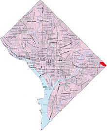
Map of Washington, D.C., with Northeast Boundary highlighted in red
Northeast Boundary is a small neighborhood located in northeast Washington, D.C. It is Eastern Avenue to the northeast, Southern Avenue to the southeast, Marvin Gaye Park to the southwest, 55th Street NE to the west.
Northeast Boundary immediately borders Seat Pleasant, Maryland.
Coordinates: 38°53′37.5″N 76°54′49.9″W / 38.89375°N 76.913861°W / 38.89375; -76.913861
Categories:
- Populated places in Washington, D.C. with African American majority populations
- Neighborhoods in Washington, D.C.
- Washington, D.C. geography stubs
Wikimedia Foundation.
2010.
Look at other dictionaries:
Northeast Boundary — is a small neighborhood located in northeast Washington, D.C. It is Eastern Avenue to the northeast, Southern Avenue to the southeast, Marvin Gaye Park to the southwest, 55th Street NE to the west.Northeast Boundary immediately borders Fairmount… … Wikipedia
Washington (state) — Washington state redirects here. For the university, see Washington State University. State of Washington … Wikipedia
Boundary Stones (District of Columbia) — The Boundary Markers of the Original District of Columbia are the 40 milestones that a survey team led by Major Andrew Ellicott placed in 1791 and 1792 to mark the future District s boundaries. Today, 37 of the marker stones survive as the oldest … Wikipedia
Washington — /wosh ing teuhn, waw shing /, n. 1. Booker T(aliaferro) /book euhr tol euh veuhr/, 1856 1915, U.S. reformer, educator, author, and lecturer. 2. George, 1732 99, U.S. general and political leader: 1st president of the U.S. 1789 97. 3. Martha… … Universalium
Washington, D.C. — This article is about the place. For the novel, see Washington, D.C. (novel). Washington, D.C. Federal district … Wikipedia
Washington — US state Name = Washington Fullname = State of Washington Flaglink = Flag of Washington Nickname = The Evergreen State Motto = Alki (Chinook Wawa: Eventually, or By and by [ [http://www1.leg.wa.gov/Legislature/StateSymbols/ State Symbols ] ]… … Wikipedia
Washington State Route 31 — State Route 31 Nearby state routes with SR 31 highlighted in red. Route inform … Wikipedia
Washington Township, Lycoming County, Pennsylvania — Infobox Settlement official name = Washington Township, Lycoming County, Pennsylvania other name = native name = nickname = settlement type = Township motto = imagesize = image caption = Farms and woodlands in Washington Township with the second… … Wikipedia
Washington Street (Boston) — Old South meeting house, Washington St., 1968 … Wikipedia
Northeast blackout of 2003 — States and provinces that experienced the blackout; not all areas within these political boundaries were affected. The Northeast blackout of 2003 was a widespread power outage that occurred throughout parts of the Northeastern and Midwestern… … Wikipedia

