civic — civic, civil, civilian are not close synonyms but rather words whose meanings lend themselves to confusion. In a sense they have a common meaning: of, relating to, or characteristic of a citizen but in each case the word citizen has a specific or … New Dictionary of Synonyms
Civic Act-up — 公民起動 Chairman Cyd Ho Founded 1 July 2003 Ideology Ethnic minority, Urban design, Social Welfare, Social Democracy (minority factions) … Wikipedia
Civic Party — For other uses, see Civic Party (disambiguation). Civic Party 公民黨 Chairman Kenneth Chan … Wikipedia
Civic Biology — A Civic Biology: Presented in Problems (usually referred to as just Civic Biology) was a biology textbook written by George William Hunter, published in 1914. It is the book which the state of Tennessee required high school teachers to use in… … Wikipedia
Democratic Alliance for the Betterment and Progress of Hong Kong — 民主建港協進聯盟 Chairman Tam Yiu Chung … Wikipedia
Heights Community Council (Cincinnati, Ohio) — Infobox Settlement official name = The Heights Community Council nickname = The Heights” / “HCC” / “Clifton Heights” / “University Heights” motto = Your Community Voice image caption = St. Monica St. George image mapsize = 250px map caption = The … Wikipedia
Ramsdell Theatre — Infobox nrhp | name =Ramsdell Theatre nrhp type = caption = location= Manistee, Michigan lat degrees = 44 lat minutes = 14 lat seconds = 45.06 lat direction = N long degrees = 86 long minutes = 19 long seconds = 25.74 long direction = W locmapin … Wikipedia
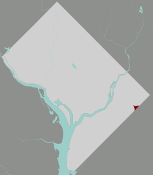
Marshall Heights, Washington, D.C. — Map of Washington, D.C., with Marshall Heights highlighted in red Marshall Heights, sometimes called Glendale, is a residential neighborhood in Southeast Washington, D.C. It is bounded by East Capitol Street and Central Avenue SE on the north,… … Wikipedia
Chevy Chase (Washington, D.C.) — Map of Washington, D.C., with Chevy Chase highlighted in maroon Chevy Chase is a neighborhood in northwest Washington, D.C. It borders Chevy Chase, Maryland, a collection of similarly affluent neighborhoods. Contents … Wikipedia
Cleveland Park — For The Wolfstone song, see Unleashed (album). Cleveland Park Historic District U.S. National Register of Historic Places … Wikipedia

