- North Fork Bull Run River
-
North Fork Bull Run River Name origin: Possibly after cattle that escaped and ran wild along the river between 1849 and 1855[1] Country United States State Oregon County Multnomah County Source Mount Hood National Forest - location Palmer Lake, Multnomah County, Oregon - coordinates 45°33′52″N 121°59′47″W / 45.56444°N 121.99639°W [2] Mouth Bull Run River - location Bull Run Reservoir 1, Multnomah County, Oregon - elevation 1,096 ft (334 m) [2] - coordinates 45°29′38″N 122°02′06″W / 45.49389°N 122.035°W [2] Length 6 mi (10 km) [3] Basin 8.32 sq mi (22 km2) [4] Discharge for mouth - average 72.6 cu ft/s (2 m3/s) [4] - max 9,700 cu ft/s (275 m3/s) - min 8.6 cu ft/s (0 m3/s) 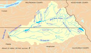 Bull Run River watershed
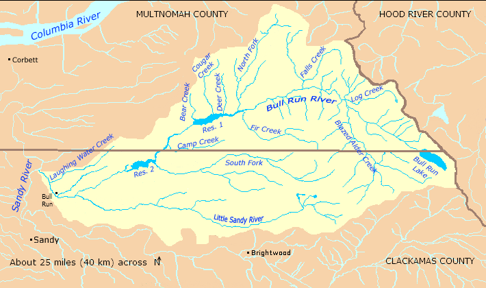
 Location of the mouth of the North Fork Bull Run River in Oregon
The North Fork Bull Run River is a tributary, about 6 miles (10 km) long, of the Bull Run River in the U.S. state of Oregon. Part of the system that provides drinking water to the city of Portland, it flows generally south through a protected part of the Mount Hood National Forest in Multnomah County. It joins the Bull Run River at Bull Run Reservoir 1.
Contents
Course
The river, which begins at Palmer Lake, slightly southeast of Palmer Peak, flows south and slightly west through Multnomah County and the Mount Hood National Forest within the Bull Run Watershed Management Unit (BRWMU). It receives an unnamed tributary from the right as it passes through Latourell Prairie. Another unnamed tributary enters from the left just before the North Fork reaches a United States Geological Survey (USGS) stream gauge and enters Bull Run Reservoir 1, which is part of the Bull Run River mainstem. The North Fork has no named tributaries. Its mouth is roughly 13.5 miles (21.7 km) from the confluence of the Bull Run River with the Sandy River.[5]
Discharge
Since 1965, the USGS has monitored the flow of the North Fork Bull Run River at a stream gauge at the river mouth. The average flow between then and 2007 was 72.6 cubic feet per second (2.06 m3/s). This is from a drainage area of 8.32 square miles (21.55 km2). The maximum flow recorded during this period was 9,700 cubic feet per second (270 m3/s) on January 20, 1972, probably affected by a surge of water related to a landslide. The minimum was 8.6 cubic feet per second (0.24 m3/s) on October 19–29, 1987.[4]
Watershed
The Bull Run River watershed, which includes the North Fork Bull Run River, drains 139 square miles (360 km2).[6] The basin, which is the main source of Portland's drinking water, is largely restricted to uses related to water collection, storage, treatment, and forest management. The North Fork Bull Run River basin of 8.32 square miles (21.5 km2) amounts to about 6 percent of the total Bull Run River watershed,[4] which is managed by the Portland Water Bureau and the United States Forest Service.[7]
See also
References
- ^ McArthur, p. 123
- ^ a b c "North Fork Bull Run River". Geographic Names Information System (GNIS). United States Geological Survey. November 28, 1980. http://geonames.usgs.gov/pls/gnispublic/f?p=gnispq:3:::NO::P3_FID:1146915. Retrieved January 21, 2010.
- ^ DeLorme Mapping. Oregon Atlas and Gazetteer (Map) (2008 ed.). Section 24, 30. ISBN 978-0-89933-347-2. Approximate length determined by map scale and ruler.
- ^ a b c d "Water-Data Report 2007: 14138900 North Fork Bull Run River near Multnomah Falls, OR" (PDF). United States Geological Survey. http://wdr.water.usgs.gov/wy2007/pdfs/14138900.2007.pdf. Retrieved January 21, 2010.
- ^ United States Geological Survey. "United States Geological Survey Topographic Map, Brightwood, Multnomah Falls, and Tanner Butte quadrants". TopoQuest. http://www.topoquest.com/map.php?lat=45.493889&lon=-122.035&datum=nad83&zoom=4. Retrieved January 22, 2010.
- ^ Portland Water Bureau, "Landscape Conditions", p. 52
- ^ "Map of Bull Run Management Unit". Portland Water Bureau. http://www.portlandonline.com/water/index.cfm?c=29923&a=222220. Retrieved December 27, 2009.
Works cited
- McArthur, Lewis A., and McArthur, Lewis L. (2003) [1928]. Oregon Geographic Names, 4th edition. Portland: Oregon Historical Society Press. ISBN 0-87595-277-1.
- Portland Water Bureau (2007). "Landscape Conditions", Chapter 4 of Current Habitat Conditions in the Habitat Conservation Plan Area. Portland, Oregon: Portland Water Bureau. Retrieved March 9, 2010.
External links
- Sandy River Basin Watershed Council
- Sandy River Basin Partners
- Forest Service, Mount Hood National Forest
Watersheds in Portland, Oregon Major 
Minor Balch Creek · Columbia Slough · Crystal Springs Creek · Fanno Creek · Johnson Creek · Stephens Creek · Tryon CreekDrinking water Bull Run River · Portland Water BureauCategories:- Rivers of Oregon
- Landforms of Multnomah County, Oregon
- Mount Hood National Forest

Wikimedia Foundation. 2010.