- Balch Creek
Geobox | River
name = Balch Creek
category = Creek
image_size =
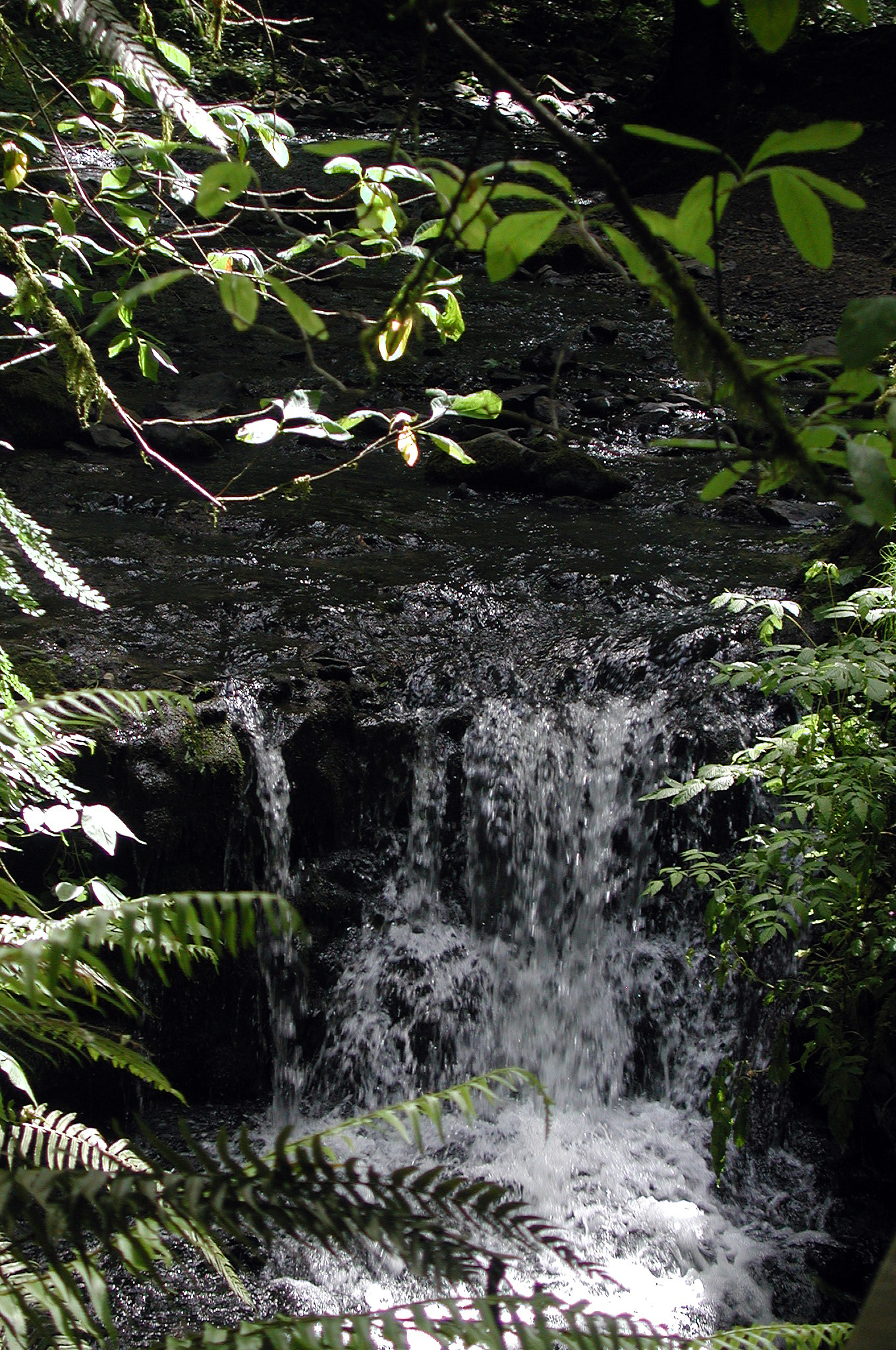
image_caption = Waterfall in Macleay Park
etymology = Danford Balch, early settler
country = United States
country_
state = Oregon
district_type = County
district = Multnomah
source =Tualatin Mountains (West Hills)
source_location = Portland
source_region = Multnomah County
source_state =Oregon
source_elevation_imperial = 1116
source_elevation_note = Source elevation derived fromGoogle Earth search using GNIS source coordinates.]
source_length_imperial =
source_lat_d = 45
source_lat_m = 32
source_lat_s = 34
source_lat_NS = N
source_long_d = 122
source_long_m = 45
source_long_s = 35
source_long_EW = W
source_coordinates_note =
mouth_name =Willamette River
mouth_location = Portland
mouth_district =
mouth_region = Multnomah County
mouth_state =Oregon
mouth_country =
mouth_note =
mouth_lat_d = 45
mouth_lat_m = 32
mouth_lat_s = 16
mouth_lat_NS = N
mouth_long_d = 122
mouth_long_m = 42
mouth_long_s = 41
mouth_long_EW = W
mouth_coordinates_note =
mouth_elevation_imperial = 46
mouth_elevation_note = cite web | work =Geographic Names Information System (GNIS)| publisher =United States Geological Survey (USGS) | date = October 22, 1999 | url = http://geonames.usgs.gov/pls/gnispublic/f?p=gnispq:3:::NO::P3_FID:1851907 | title = Balch Creek | accessdaymonth=May 5, | accessyear=2008 ]
length_imperial = 3.5
length_round = 0
length_note =
watershed_imperial = 3.5
watershed_round = 1
watershed_note =
discharge_location = Lower Macleay Park
discharge_round = 2
discharge_imperial = 1.05
discharge_note = [The average annual flow was derived by adding the average summer flow given by the Portland Bureau of Environmental Services to the average winter flow and dividing by 2.]
discharge_max_imperial = 73
discharge_min_imperial = 0
discharge1_location =
discharge1_imperial =
discharge1_note =

map_size = 300
map_caption = Balch Creek in Portland and unincorporated Multnomah County. Dashed black line shows stream course through storm sewer.cite web | last = Bureau of Environmental Services | work = Portland Maps | title = Northwest District Sewer Assets | publisher = City of Portland | date = 2008 | url = http://www.portlandmaps.com/detail.cfm?action=Sewer&propertyid=R307711&state_id=1N1E29DC%20%203200&address_id=599977&intersection_id=&dynamic_point=0&x=7635419&y=689155&place=2935%20NW%20THURMAN%20ST&city=PORTLAND&neighborhood=NORTHWEST%20DISTRICT&seg_id=192379
accessdaymonth=July 3, | accessyear=2008]
map1 = Oregon Locator Map.png
map1_caption = Location of the mouth of Balch Creek in Oregon
map1_locator = Oregon
commons =Balch Creek is a convert|3.5|mi|km|1|adj=on tributary of the
Willamette River in the U.S. state ofOregon .cite map |publisher = G.M. Johnson and Associates |title = City Streetedition = 2007 ] Beginning at the crest of the
Tualatin Mountains (West Hills), the creek flows generally east down a canyon along Northwest Cornell Road in unincorporated Multnomah County and through the Macleay Park section of Forest Park, a large municipal park in Portland. At the lower end of the park, the stream enters a pipe and remains underground until reaching the river. Danford Balch, from whom the creek takes its name, settled a land claim along the creek in the mid-19th century. After murdering his son-in-law, he became the first person legally hanged in Oregon.Basalt , mostly covered by silt in the uplands and sediment in the lowlands, underlies the Balch Creek watershed. The upper part of the watershed includes private residential land, an Audubon Society nature sanctuary, and part of Forest Park.cite web
last = Bureau of Environmental Services
work = Willamette Subwatersheds
title = Balch Subwatershed
publisher = City of Portland
date = 2008
url = http://www.portlandonline.com/bes/watershedapp/index.cfm?action=DisplayContent&SubWaterShedID=3
accessdaymonth = May 5, | accessyear = 2008] Mixed conifer forest ofCoast Douglas-fir ,western redcedar , andwestern hemlock with a well-developedunderstory of shrubs and flowering plants is the natural vegetation. Sixty-two species of mammals and more than 112 species of birds use Forest Park. [Houle, pp. 36–49] A small population ofcutthroat trout resides in the stream, which in 2005 was the only major water body in Portland that met state standards for bacteria, temperature, and dissolved oxygen.Although nature reserves cover much of the upper and middle parts of the watershed, industrial sites dominate the lower part. Historic Guild's Lake occupied part of the lower watershed through the 19th century, and in 1905 city officials held the
Lewis and Clark Centennial Exposition there on an artificial island. After the exposition, developers converted the lake and its surrounds to industrial use, and in 2001 the Portland City Council declared the site to be an "industrial sanctuary".cite web | last = Bureau of Planning | title = Guild’s Lake Industrial Sanctuary Plan | publisher = City of Portland | date = 2001 | format = pdf | url = http://www.portlandonline.com/shared/cfm/image.cfm?id=58694 | accessdaymonth = June 5, | accessyear = 2008]Course
Balch Creek begins in the Forest Park neighborhood in unincorporated Multnomah County near the intersection of Northwest Skyline Boulevard and Northwest Thompson Road at the crest of the West Hills. It flows generally east about convert|3.5|mi|km to its confluence with the Willamette River, a major tributary of the
Columbia River . The creek drops from convert|1116|ft|m abovesea level at its source to convert|46|ft|m at its mouth, a total of convert|1070|ft|m. Most of this occurs in the first convert|2.5|mi|km. In the hills, the stream gradient (slope) generally ranges from 15 to 30 percent interspersed with sections of less than 15 percent along the middle reaches.cite web | last = Bureau of Environmental Services | title = General Description | work = Willamette Subwatersheds: Balch | publisher = City of Portland | date = 2008 | url = http://www.portlandonline.com/bes/watershedapp/index.cfm?action=DisplayContent&SubWaterShedID=3&SubjectID=4&TopicID=56&SectionID=1
|accessdaymonth = June 4, |accessyear = 2008 ]From its source, the creek runs east on private property near Forest Park, a large municipal park in Portland, before turning briefly south about convert|3|mi|km from the mouth. Soon thereafter, the stream receives an unnamed tributary on the right and turns southeast on private property along Northwest Cornell Road. It enters the city and the Portland Audubon Sanctuary simultaneously about convert|2|mi|km from the mouth, receives two more unnamed tributaries on the right, and flows northeast, entering the part of Forest Park known as Macleay Park.cite map |publisher = Friends of Forest Park |title = Hiking and Running Guide to Forest Park |edition = 2003 |section = "Index" and "Stone House"] A highly-detailed Forest Park map produced and published by Erik Goetze, a freelance cartographer, can be viewed at [http://www.artofgeography.com/maps/fp/index.html The Art of Geography] .] [cite web | last = Bureau of Planning | title = Map of Portland, Oregon, city limits and urban services boundary | publisher = City of Portland | date = 2007 | url = http://www.portlandonline.com/shared/cfm/image.cfm?id=51672 | format = pdf | accessdaymonth = June 11, | accessyear = 2008]
For about convert|0.25|mi|km the creek parallels Wildwood Trail, the main hiking trail in Forest Park, until reaching a former public restroom known as the Stone House. From here Balch Creek runs beside the Lower Macleay Trail, another hiking trail, for about convert|0.8|mi|km. [Houle, 94–97] Near Northwest Thurman Street, roughly convert|1|mi|km from the mouth, the creek flows through a trash-catching rack into an convert|84|in|cm|adj=on diameter storm sewer. The water empties into the Willamette River in the city's Northwest Industrial neighborhood at Outfall 17.cite web | last = Bureau of Environmental Services | title = Stormwater Conveyance | work = Willamette Subwatersheds: Balch | publisher = City of Portland | date = 2008 | url = http://www.portlandonline.com/bes/watershedapp/index.cfm?action=DisplayContent&SubWatershedID=3&SectionID=1&SubjectID=1&TopicID=9
accessdaymonth = June 6, | accessyear = 2008] About convert|10|mi|km below this outfall, the Willamette enters the Columbia River.Discharge
The Bureau of Environmental Services (BES) of the city of Portland monitored the flow of Balch Creek from June 1996 through September 2002 at a site, Node ABB857, where the stream leaves the surface and enters a storm sewer in Macleay Park. BES reported an average summer flow of convert|0.2|cuft/s|m3/s|, a maximum of convert|60|cuft/s|m3/s, and a minimum of 0. The average flow in winter was convert|1.9|cuft/s|m3/s, with a maximum of convert|73|cuft/s|m3/s and a minimum of 0.
Measurements taken during an individual spring, from mid-May to mid-July 2002, showed the flow starting at about convert|2.5|cuft/s|m3/s and dwindling to 0 by early June. The flow through June depended partly on the weather; the highest flow, convert|4.5|cuft/s|m3/s, occurred after a rain. Measurements taken during an individual autumn, late August to late December 2001, were close to zero until November. The largest flows during that season, convert|19.2|cuft/s|m3/s, occurred after many days of rain.cite web | last = Bureau of Environmental Services | title = Streams & Water Bodies | work = Willamette Subwatersheds: Balch | publisher = City of Portland | date = 2008
url = http://www.portlandonline.com/bes/watershedapp/index.cfm?action=DisplayContent&SubWatershedID=3&SectionID=1&SubjectID=4&TopicID=31
accessdaymonth = June 9, | accessyear = 2008 ]Geology
Solidified
lava from Grande Ronde members of theColumbia River Basalt Group underlies the Balch Creek watershed. About 16 million years ago during theMiddle Miocene , the Columbia River ran through a lowland south of its modern channel. Eruptions from linear vents in eastern Oregon and Washington flowed down this channel through what later became theWillamette Valley . These flows, some of which reached thePacific Ocean , occurred between 16.5 and 15.6 million years ago and covered almost convert|60000|mi2|km2. Geologists have identified several basalt flows in the West Hills, where they underlie the steepest slopes of Forest Park and form the columned rocks visible in parts of Balch Creek Canyon. Bishop, pp.141–48] Wind-deposited silts, unstable when wet, later covered most of the lava. Stream bank instability and siltation are common, and the threat of landslides has discouraged urban development in the hills.cite web
last = Knudsen
first = Matt
coauthors = Pentilla, Jeanine; Petersen, Luke
title = Balch Creek Watershed: Good Policy, Poor Performance
publisher = Portland State University
date = 2002
url = http://www.web.pdx.edu/~changh/balch.pdf
format = pdf
accessdaymonth = June 3,
accessyear = 2008 ]About 15,000 years ago, cataclysmic
ice age events known as theMissoula Floods or Bretz Floods originating in the Clark Fork region of northernIdaho inundated the Columbia River basin many times. These floods deposited huge amounts of debris and sediment and created newfloodplain s in the Willamette Valley. From then until the 19th century, the lower Balch Creek watershed consisted of swampy marshlands and shallow semi-permanent lakes such as historic Guild's Lake. The final convert|1|mi|km| or so of historic Balch Creek flowed across this floodplain.cite web
last = Capstone students
title = Natural History
work = Wapato Bog to Industrial Sanctuary: The Transformation of Portland's Guild's Lake
publisher = Portland State University
url = http://www.history.pdx.edu/guildslake/
accessdaymonth = June 3,
accessyear = 2008 ]History
Names
Multnomah County is named for Native Americans who lived in the area before settlement by
European American s in the 19th century. Members of the Multnomah tribe of theChinookan people lived onSauvie Island in the Willamette River and on the mainland across from the island, downstream from the mouth of Balch Creek. However, since much of the area near the lower creek was swampy, it was not favored by the Multnomah. By the 1830s, diseases carried by white explorers and traders reduced the native population by up to 90 percent in the lower Columbia basin.cite web
last = Bureau of Planning
title = Guild’s Lake Industrial Sanctuary Plan
publisher = City of Portland
date = 2001
url =
format = pdf
url = http://www.portlandonline.com/shared/cfm/image.cfm?id=58694
accessdaymonth = June 5,
accessyear = 2008 ] Historic Guild's Lake, in the lower Balch Creek watershed near the Willamette River, was named for Peter Guild (pronounced "guile"), one of the first European American settlers in the area. In 1847, he acquired nearly convert|600|acre|km2 of the watershed through a donation land claim. Although variations in the spelling of "Guild's Lake" occur in historic newspapers, maps, and other documents, "Guild's Lake" has been the preferred form since the beginning of the 20th century.The creek is named for Danford Balch, who settled a convert|640|acre|km2|adj=on donation land claim upstream of the Guild property in 1850.cite web
title = Development Patterns
work = Willamette Subwatersheds: Balch
publisher = City of Portland
date = 2008
url = http://www.portlandonline.com/bes/watershedapp/index.cfm?action=DisplayContent&SubWatershedID=3&SectionID=1&SubjectID=5&TopicID=38
accessdaymonth = June 12,
accessyear = 2008] After a man from a neighboring family eloped with a Balch daughter, Balch killed him with a shotgun. On October 17, 1859, at a publicgallows he became the first person to be hanged by the State of Oregon.cite web | last = Dibling | first = Karin |coauthors = Martin, Julie Kay; Olson, Meghan Stone; Webb, Gayle | work = Oregon Historical Quarterly | publisher = The Oregon Historical Society | date = Spring 2006 | url = http://www.historycooperative.org/journals/ohq/107.1/dibling.html| title = Guild's Lake Industrial District: The Process of Change over Time | accessdaymonth = June 5, | accessyear = 2008] cite web | last = Portland Parks and Recreation Department | publisher = City of Portland | date = 2008 | url = http://www.portlandonline.com/parks/finder/index.cfm?PropertyID=246&action=ViewPark| title = Macleay Park |accessdaymonth = May 6, | accessyear = 2008 ]Macleay Park takes its name from Donald Macleay, a Portland merchant and real-estate developer who acquired what had been the Balch property. In 1897, he donated the land for a park on condition that the city provide transport to the park for hospital patients and build paths wide enough for wheelchairs.
Early water supply
Balch Creek was one of Portland's sources of drinking water in the mid-19th century. Stephen Coffin and Finice Caruthers, two early Portland entrepreneurs, established the first public water supply for the city in 1857 by piping water from Caruthers Creek in southwest Portland through round fir logs with convert|2.5|in|cm|adj=on holes bored in them. In 1862, the Portland Water Company added water from Balch Creek to the system. The company's
infrastructure included a timber dam on Balch Creek and a convert|6|in|cm|adj=oncast iron pipe, which continued to supply water to Portland until the 1880s. The Bull Run River in theCascade Range east of the city began supplying most of Portland's drinking water in 1895.cite web
last = Oliver
first = Charles E.
title = Early, Early Water System History 1857–1895
publisher = Portland Water Bureau
date = 2007 reprint of 1927 article in "Pacific Engineering"
url = http://www.portlandonline.com/WATER/index.cfm?a=164312&c=41924
accessdaymonth = June 14,
accessyear = 2008]Industry
One of the first industries in the Guild's Lake area was a sawmill built in the 1880s. Although large parts of the land remained undeveloped until the early 20th century, lumber mills, grain storage structures, railroads, and docks appeared along the waterfront. The Guild's Lake Rail Yard, built by the
Northern Pacific Railway in the 1880s, became an important switching yard for trains.In 1905, the
Lewis and Clark Centennial Exposition , held on an artificial island in Guild's Lake, helped spur growth in the area. After the exposition ended, developers filled the lake and its surrounds with soilsluice d from parts of the Balch Creek watershed in the West Hills above the floodplain or dredged from the Willamette River. Civic leaders promoted the Guild's Lake area as a good place for industry, and by the mid-1920s the lake was gone. The USGS places historic Guild's Lake at coordinates coord|45.5470620|-122.7206530 at an elevation of convert|33|ft|m above sea level between what later became Northwest Saint Helens Road and Northwest Yeon Street, slightly west of Northwest 35th Avenue in Portland.cite web | work = Geographic Names Information System | publisher = U.S. Geological Survey | date = September 14, 1999 | url = http://geonames.usgs.gov/pls/gnispublic/f?p=gnispq:3:::NO::P3_FID:1851701 | title = Guild Lake (historical) | accessdaymonth = June 5, | accessyear = 2008] [Modern location derived by usingGoogle Earth and GNIS coordinates.]Between the 1890s and the 1930s, channel-deepening in the Willamette River improved the city's status as a deep-water seaport, as did completion in 1914 of a port terminal. Guild's Lake, close to highways as well as marine and rail terminals, became the most important industrial area in Portland. After
World War II , chemical and petroleum processing and storage, metals manufacturing, and other large industries expanded in the area. In 2001, the Portland City Council adopted the Guild's Lake Industrial Sanctuary Plan aimed at protecting the area's "long-termeconomic viability as an industrial district."Watershed
d for parks and other open space, and about 20 percent is zoned for heavy industry near the Willamette River. Multnomah County has jurisdiction over convert|586|acre|ha, about a quarter of the watershed. Lands zoned for residential farms and forests occupy about 13 percent of the total, mostly along the watershed's western edge. A mixture of residential, commercial, and other designations make up smaller segments.cite web
last = Bureau of Environmental Services
title = Current Zoning
work = Willamette Subwatersheds: Balch
publisher = City of Portland
date = 2008
url = http://www.portlandonline.com/bes/watershedapp/index.cfm?action=DisplayContent&SubWatershedID=3&SectionID=1&SubjectID=5&TopicID=5
accessdaymonth = June 11, | accessyear = 2008] About 1,600 people lived in the Balch Creek watershed in 2000,cite web
last = Bureau of Environmental Services
title = Population
work = Willamette Subwatersheds: Balch
publisher = City of Portland
date = 2008
url = http://www.portlandonline.com/bes/watershedapp/index.cfm?action=DisplayContent&SubWatershedID=3&SectionID=1&SubjectID=5&TopicID=52
accessdaymonth = June 6,
accessyear = 2008] and about 6,700 people worked there.cite web
last = Bureau of Environmental Services
title = Employment
work = Willamette Subwatersheds: Balch
publisher = City of Portland
date = 2008
url = http://www.portlandonline.com/bes/watershedapp/index.cfm?action=DisplayContent&SubWatershedID=3&SectionID=1&SubjectID=5&TopicID=53
accessdaymonth = June 12,
accessyear = 2008 ] Nearby watersheds include those of other small streams flowing directly into the Willamette along the east flank of the West Hills. The city refers to these as the Johnson-Nicolai subwatershed to the southeast, and the Kittredge and Salzman subwatersheds to the northwest. The Balch Creek watershed abuts theTualatin River watershed at the crest of the West Hills. [Watershed boundaries are shown on an [http://www.portlandonline.com/bes/watershedapp/index.cfm?action=DisplayContent&SubWaterShedID=3 interactive map published by the City of Portland] .]Rainfall in the watershed from 1977 to 2002 averaged about convert|40|in|mm per year. About convert|30|in|mm of the total fell from November through April, and about convert|10|in|mm fell from May through October.cite web
last = Bureau of Environmental Services
title = Rainfall Summary Table
work = Willamette Subwatersheds: Balch
publisher = City of Portland
date = 2008
url = http://www.portlandonline.com/bes/watershedapp/index.cfm?action=DisplayReference&ID=59
accessdaymonth = June 10,
accessyear = 2008] Minor flooding has occurred near the trash rack and caused occasional basement flooding along nearby streets. [An inclined rack allows debris to "ride up the trash rack as water levels rise." Workers stand on the rack and remove debris with a rake. cite web
last = Bureau of Environmental Services
title = Trash Racks and Safety Grates; Trash Rack Design
work = Sewer and Drainage Facilities Design Manual
publisher = City of Portland
date = June 2007
url = http://www.portlandonline.com/shared/cfm/image.cfm?id=174414
format = pdf
accessdaymonth = July 3,
accessyear = 2008 ]Vegetation
(EPA). [cite web
last = Thorson
first = T.D.
coauthors = Bryce, S.A.; Lammers, D.A., "et al."
title = Ecoregions of Oregon (front side of color poster with map, descriptive text, summary tables, and photographs)
publisher =United States Geological Survey
date = 2003
url = ftp://ftp.epa.gov/wed/ecoregions/or/or_front.pdf
format = pdf
accessdaymonth = June 19,
accessyear = 2008 Reverse side [ftp://ftp.epa.gov/wed/ecoregions/or/or_back.pdf here] ] The historic lower Balch Creek watershed through the 1880s was a mixture of open water, wetlands, grassland, and forest, while above the flood plain the watershed consisted of closed canopy forest.European American s who settled here in the 19th century logged much of this forest and filled the wetlands. In 2002, aerial photographs showed that buildings, parking lots, shoreline structures, and other cleared areas covered most of the lower floodplain. On the other hand, hill forests protected from major disturbance covered about 65 percent of the watershed.Above the floodplain, much of the habitat in the watershed consists of mixed conifer forest. Trees and shrubs, including stands of
red alder andcottonwood trees, cover about 88 percent of the middle reaches. Near the headwaters, the forests consist mainly of mixed conifers and hardwoods with a few olderDouglas-fir s. Common species include big leaf maple,willow , western hemlock, red alder, western red cedar, and Douglas-fir. Most of this forest is relatively young. In Forest Park, old growth forest, undisturbed for 250 years or more, exists mainly in isolated patches. [Houle, p. 22]Forest Park and other areas of the watershed have an
understory of well-developed shrubs including ferns,Oregon-grape , vine maple,salal , red huckleberry, [Houle, p. 18] Fendler's waterleaf, Indian plum, salmonberry, andstinging nettle .cite web
title = Visiting the Sanctuary
publisher = Audubon Society of Portland
url = http://www.audubonportland.org/sanctuaries/visiting
accessdaymonth = June 28,
accessyear = 2008 ] Among the prominent wildflowers arewild ginger , Hooker's fairy bells, vanilla leaf, evergreen violet, andtrillium . [Houle, p. 18] Rare or uncommon species include old conifers, Western wahoo shrubs, and ornamental dawn redwoods. Invasive species are English ivy, European holly,clematis ,morning glory , and Himalayan blackberry.cite web |last = Bureau of Environmental Services| title = Habitat and Biological Communities | work = Willamette Subwatersheds: Balch | publisher = City of Portland | date = 2008 | url = http://www.portlandonline.com/bes/watershedapp/index.cfm?action=DisplayContent&SubWaterShedID=3&SubjectID=3&SectionID=1
accessdaymonth = June 12, | accessyear = 2008]Fish and wildlife
The historic creek likely supported diverse fish species, including salmon. After people filled the wetlands and diverted the lower stretch of the creek into a pipe, fish could no longer migrate to and from the Willamette River. The industrial parts of the watershed have no remaining aquatic habitat, but above the pipe the aquatic habitat remains relatively high, and Balch Creek and its tributaries support a resident population of cutthroat trout of up to about convert|7|in|cm.cite web
last = Bureau of Environmental Services
title = Aquatic Habitat
work = Willamette Subwatershed: Balch
publisher = City of Portland
date = 2008
url = http://www.portlandonline.com/bes/watershedapp/index.cfm?action=DisplayContent&SubWaterShedID=3&SubjectID=3&TopicID=26&SectionID=1
accessdaymonth = June 13, | accessyear = 2008 ] [cite web
last = Tinus
first = Eric S.
coauthors = Koloszar, James A.; Ward, David L.
title = Abundance and Distribution of Fish in City of Portland Streams
publisher = Oregon Department of Fish and Wildlife
date = December 2003
url = http://www.portlandonline.com/shared/cfm/image.cfm?id=51651
accessdaymonth = June 14,
accessyear = 2008 ] In 2005, Balch Creek was the only major water body in Portland that met state water quality standards for bacteria, temperature and dissolved oxygen.cite web
last = Auditor's Office
title = Actions for Watershed Health, 2005 Portland Watershed Management Plan Implementation
publisher = City of Portland
date = 2005
url = http://www.portlandonline.com/auditor/index.cfm?c=41872&a=111687
accessdaymonth = June 14,
accessyear = 2008 ]Nearby tracts of habitat strongly affect the wildlife in the Balch Creek watershed. This is especially true of Forest Park, which extends into other watersheds to the northwest. Birds and animals from these watersheds and from the
Tualatin River valley, the Coast Range, the Willamette River, Sauvie Island, the Columbia River, and theVancouver, Washington , lowlands, move in and out of the park with relative ease.cite web
last = Bureau of Environmental Services
title = Wildlife Communities
work = Willamette Subwatershed: Balch
publisher = City of Portland
date = 2008
url = http://www.portlandonline.com/bes/watershedapp/index.cfm?action=DisplayContent&SubWatershedID=3&SectionID=1&SubjectID=3&TopicID=25
accessdaymonth = June 13,
accessyear = 2008] Sixty-two mammal species, including thenorthern flying squirrel , black-tailed deer, creepingvole ,bobcat , coyote, Mazama pocket gopher, little brown bat, Roosevelt elk, and Pacific jumping mouse use Forest Park. [Houle, pp. 36–49] Blue Grouse,Great Horned Owl ,Hairy Woodpecker ,Bewick's Wren ,Orange-crowned Warbler ,Osprey , andHermit Thrush are among the 112 species of birds that frequent the area. [Houle, pp. 36–49] Amphibian species seen at the Audubon Society pond includerough-skinned newt s, Pacific tree frogs, andsalamander s.Pressure from habitat loss, pollution, hunting, and urban development has reduced or eliminated the large predators such as wolves, bears, and wild cats and has led to increased numbers of small predators such as
weasel s andraccoon s. Roads through the watershed severely hamper the movement of large animals. Invasive plant species such as English ivy have made the habitat simpler and less supportive of native insects and the salamanders and other amphibians that feed on them. Citizen groups such as the No Ivy League and Friends of Forest Park have engaged in projects to remove ivy, to plant native species, and to widen and protect riparian zones.See also
*
List of rivers of Oregon Works cited
* Bishop, Ellen Morris (2003). "In Search of Ancient Oregon: A Geological and Natural History". Portland, Oregon: Timber Press. ISBN 978-0-88192-789-4
* Houle, Marcy Cottrell (1996). "One City's Wilderness: Portland's Forest Park", second edition. Portland: Oregon Historical Society Press. ISBN 0-87595-284-4.Notes and references
External links
* [http://www.history.pdx.edu/guildslake/ Guild's Lake history project]
* [http://www.forestparkconservancy.org/ Forest Park Conservancy and Friends of Forest Park]
* [http://yosemite.epa.gov/water%5Cadopt.nsf/by+State/49363F69DF93FE278525653600527DE2?OpenDocument Friends of Balch Creek]

Wikimedia Foundation. 2010.