- Wyham cum Cadeby
-
Coordinates: 53°26′09″N 0°04′11″W / 53.435880°N 0.069639534°W
Wyham cum Cadeby 
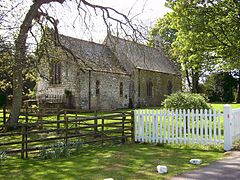
All Saints, Wyham
 Wyham cum Cadeby shown within Lincolnshire
OS grid reference TF283949 District East Lindsey Shire county Lincolnshire Region East Midlands Country England Sovereign state United Kingdom Post town Grimsby Postcode district DN36 5 Police Lincolnshire Fire Lincolnshire Ambulance East Midlands EU Parliament East Midlands UK Parliament Louth and Horncastle (UK Parliament constituency) List of places: UK • England • Lincolnshire Wyham cum Cadeby (otherwise Wyham with Caldeby[1]) is a depopulated civil parish[2] in the East Lindsey[3] district of Lincolnshire, England.
Wyham cum Cadeby consists of the remaining hamlet of Wyham at grid reference TF277951[4] and the former village of Cadeby (otherwise North Cadeby) at TF271960,[5] both settlements are deserted medieval villages. The nearest village is Ludborough about one mile to the east across the A18 road and the nearest town is Louth 7 miles (11 km) away.
The parish church, dedicated to All Saints once seated 90. It was restored in 1886,[6] declared redundant and sold in 1982.[7] The parish records are held in Lincoln.[8]
There is a former chalk quarry which has been converted to a clay and skeet shooting ground.
References
- ^ Vision of Britain
- ^ "Parish Administration record, East Lindsey". http://www.eldc.gov.uk/committee/mgParishCouncilDetails.aspx?ID=406&LS=1.
- ^ District council
- ^ "National monument record for Wyham". http://pastscape.english-heritage.org.uk/hob.aspx?hob_id=353255.
- ^ "National monument record for Cadeby". http://pastscape.english-heritage.org.uk/hob.aspx?hob_id=353252.
- ^ "National monument record for Church, not updated since it was converted". http://www.pastscape.org.uk/hob.aspx?hob_id=527299.
- ^ GENUKI
- ^ "Index of Parish Records held by Lincolnshire Archive". http://fsd.lincolnshire.gov.uk/upload/public/attachments/661/Wyham_cum_Cadeby.pdf.
External links
Categories:- Villages in Lincolnshire
- Civil parishes in Lincolnshire
- East Lindsey
- Lincolnshire geography stubs
Wikimedia Foundation. 2010.

