- Nong Phai District
-
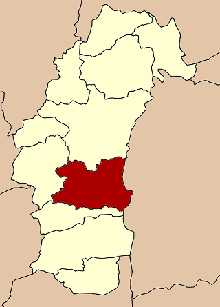
Nong Phai
หนองไผ่— Amphoe — Amphoe location in Phetchabun Province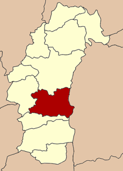
Coordinates: 15°59′25″N 101°3′45″E / 15.99028°N 101.0625°ECoordinates: 15°59′25″N 101°3′45″E / 15.99028°N 101.0625°E Country  Thailand
Province Phetchabun Seat Tambon Muban Amphoe established Area – Total 1,360.2 km2 (525.2 sq mi) Population (2000) – Total 115,832 – Density 85.2/km2 (220.7/sq mi) Time zone THA (UTC+7) Postal code 67140 Geocode 6707 Nong Phai (Thai: หนองไผ่) is a district (Amphoe) in the southern part of Phetchabun Province, northern Thailand.
History
The area was created to be a minor district (King Amphoe) in 1961. It was officially upgraded to a full district in 1963.
Geography
Neighboring district are (from the east clockwise) Nong Bua Daeng and Phakdi Chumphon of Chaiyaphum Province, Bueng Sam Phan, Chon Daen and Mueang Phetchabun of Phetchabun Province.
The main water resource is the Pa Sak River.
Administration
The district is subdivided into 13 subdistricts (tambon), which are further subdivided into 135 villages (muban). There are three township (thesaban tambon) within the district - Na Chaliang, Nong Phai and Yang Ngam, each covering parts of the same-named tambon. There are further 13 Tambon administrative organizations (TAO).
1. Kong Thun กองทูล 2. Na Chaliang นาเฉลียง 3. Ban Phot บ้านโภชน์ 4. Tha Daeng ท่าแดง 5. Phet Lakhon เพชรละคร 6. Bo Thai บ่อไทย 7. Huai Pong ห้วยโป่ง 8. Wang Tha Di วังท่าดี 9. Bua Watthana บัววัฒนา 10. Nong Phai หนองไผ่ 11. Wang Bot วังโบสถ์ 12. Yang Ngam ยางงาม 13. Tha Duang ท่าด้วง Mueang Phetchabun · Chon Daen · Lom Sak · Lom Kao · Wichian Buri · Si Thep · Nong Phai · Bueng Sam Phan · Nam Nao · Wang Pong · Khao Kho
Categories:- Amphoe of Phetchabun
- Northern Thailand geography stubs
Wikimedia Foundation. 2010.