- Natural regions of Germany
-
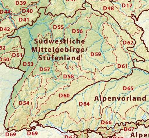
 Major natural regions in Germany
This division of Germany into major natural regions takes account primarily of geomorphological, geological, hydrological and pedological criteria in order to divide the country into large, physical units with a common geographical basis. Political boundaries play no part in this, apart from defining the national border.
The following list shows the division of Germany into its major natural regions as classified by the Federal Office for Nature Conservation (Bundesamt für Naturschutz) (BfN) in 1994, who have numbered these regions from D01-D73. This largely followed the previous categorization of major regional units, numbered 01-90, by Meynen[1], however, in some cases two to four old regional units have been replaced by a single new one, whilst the old North and Baltic Sea region has been split into four new ones.
In addition to a division of Germany by natural regions, the Federal authorities have also produced a division by so-called 'landscape areas' (Landschaftsräume) that is based more on human utilisation of various regions and so has clearly different boundaries.
Contents
The major natural regions of Germany according to the BfN
Germany can be divided into 3 major geographical regions: the Northern Lowland or North German Plain, the Central Uplands and the Alps running roughly west to east across the country[2].
The BfN's classification has seven major divisions and 73 natural regions. The seven major regions are: the Northeast German Plain, the Northwest German Plain, the Western Central Uplands, the Eastern Central Uplands, the South German Scarplands[3][2] and Alpine Foreland as well as the North and Baltic Seas.
The BfN's 73 natural regions listed below in numerical order together with their English names. The old numbering system is shown in brackets after the name. Where several old regional units have been grouped into one new region, the old units are shown under their new regional name and their location inside the new region is given.
The English names of natural regions are primarily based on Dickinson (1964)[3] and Elkins (1972)[2] where their divisions correspond closely to the BfN's. In such cases the source of the English name is referenced.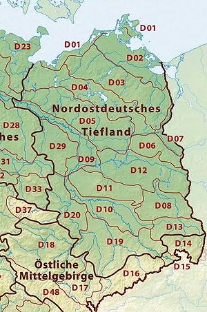
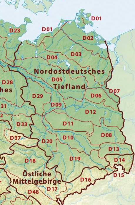
Northeast German Plain
- D01 Mecklenburg Coastal Lowland[2] (71)
- D02 Northeast Mecklenburg Lowland (including the Szczecin Lagoon) (72-73)
- Northeast Mecklenburg Lowland (72, northwest and centre)
- Szczecin Lagoon (73 east)
- D03 Mecklenburg Lake Plateau Hinterland (74)
- D04 Mecklenburg Lake Plateau[2] (75)
- D05 Mecklenburg-Brandenburg Plateau and Upland (76-78)
- Southwest Foreland of the Mecklenburg Lake Plateau (76, northwest)
- North Brandenburg Plateau and Upland (77, centre)
- Luchland (78, southeast)
- D06 East Brandenburg Plateau (79)
- D07 Oder Valley (80)
- D08 Lusatian Basin and Spreewald[2] (83-84)
- D09 Middle Elbe Plain[3] (87)
- D10 Elbe-Mulde Plain (88)
- D11 Fläming Heath[3][2] (85)
- D12 Brandenburg Heath and Lake District (81-82)
- Central Brandenburg Plateaux and Lowland (81, west)
- East Brandenburg Heath and Lake District (82, east)
- D13 Upper Lusatian Plateau[2] (89)
- Saxon Lowland*[3] (new overarching region/division)
- D19 Saxon Upland and Ore Mountain Foreland[2] (45-46)
- Ore Mountain Foreland (45, south)
- Saxon Upland[2] (including Leipziger Land) (46, west, north and east)
- D14 Upper Lusatia[3][2] (44) - excluding the Lusatian Upland (441)
- D19 Saxon Upland and Ore Mountain Foreland[2] (45-46)
- D20 Eastern Harz Foreland and Börde (50)
- D29 Wendland and Altmark[3] (86)
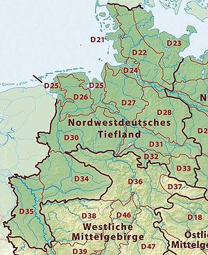
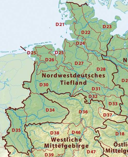
Northwest German Plain
- D21 Schleswig-Holstein Marsh[3] (68)
- D22 Schleswig-Holstein Geest[3][2] (69)
- D23 Schleswig-Holstein Uplands[3] (70)
- D24 Lower Elbe Marsh[3] (67)
- D25 Ems and Weser Marsh (61)
- D26 East Frisian Geest[3] (60)
- D27 Stade Geest[3] (63)
- D28 Lüneburg Heath[3][2] (64)
- D30 Dümmer and Ems-Hunte Geest (58-59)
- Dümmer Geest Lowland (58, south)
- Ems-Hunte Geest[3] (59, north)
- D31 Weser-Aller Plain (62)
- D32 Lower Saxony Börde[3] (52)
- D33 North Harz Foreland[3] (51)
- D34 Westphalian Lowland[3] or Basin[2] (Münster Lowland) (54)
- D35 Lower Rhine Plain[3] and Cologne Lowland[3][2] (55, 57)
- Cologne Lowland[3][2] (55, south)
- Lower Rhine Plain[3] (57, north)
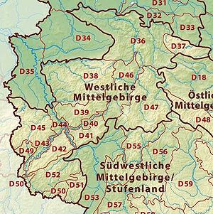
Western Central Uplands
- D36 Lower Saxon Hills[2] (including the Weser[3] and Leine Uplands[3]) (36-37, 53)
- Lower Weser Uplands (53, northwest)
- Upper Weser Uplands (36, centre)
- Leine Uplands[3] (37, east)
- D37 Harz[3] (38)
- D38 Sauerland (Süderbergland)[3][2] (33)
- D39 Westerwald[3][2] (32)
- D40 Gießen-Koblenz Lahn Valley (31)
- D41 Taunus[3][2] (30)
- D42 Hunsrück[3][2] (24)
- D43 Moselle Valley[3] (25)
- D44 Middle Rhine[2] (including Siebengebirge) (29)
- D45 Eifel[3][2] (including Venn Foreland) (27-28, 56)
- East Eifel (27, east and centre)
- West Eifel (28, west)
- Venn Foreland (56, extreme northwest)
- D46 West Hesse Highlands (34)
- D47 East Hesse Highlands (35)
- D49 Bitburg Land[3][2] (Gutland) (26)
- D50 Palatine-Saar Muschelkalk Region (18)
- D51 Palatinate Forest[2] (the Haardt[3]) (17)
- D52 Saar-Nahe Hills[2] or Upland[3] (19)
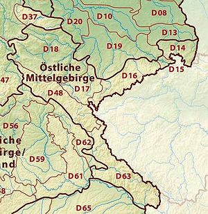
Eastern Central Uplands
- Saxon Highlands and Uplands* (new supra-region)
- D14 Upper Lusatia[3] (44) -
- only 441 Upper Lusatian Plateau[2]
- D15 Saxon-Bohemian Chalk Sandstone Region (43)
- D16 Ore Mountains[2] (Erzgebirge) (42)
- D17 Vogtland[3][2] (41)
- D14 Upper Lusatia[3] (44) -
- D18 Thuringian Basin including outer plateaus (47-48)
- Southern plateau of the Thuringian Basin (47, south)
- Thuringian Basin[2] (48; north, west and centre)
- D48 Thuringian-Franconian Highlands (39)
- D63 Upper Palatine-Bavarian Forest (40)
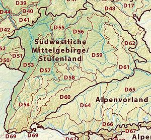
South German Scarplands[3][2]
- D53 Upper Rhine Plain[3][2] (20-23)
- Southern Upper Rhine Plain (20, extreme south)
- Middle Upper Rhine Plain (21, south of centre)
- Northern Upper Rhine Plain (22, centre and north)
- Rhine-Main Lowland[2] (23, northeast)
- D54 Black Forest[3][2] (15)
- D55 Odenwald[3][2], Spessart[3][2] and South Rhön (14)
- D56 Mainfranken Plateau (13)
- D57 Gäu Plateaus[2] (12)
- D58 Swabian Keuper-Lias Plains[3] (10)
- D59 Franconian Keuper-Lias Plains[3] (11)
- D60 Swabian Jura[3][2] (09)
- D61 Franconian Jura[3][2] (08)
- D62 Upper Palatinate-Upper Main Hills (07)
- D69 Dinkelberg and Upper Rhine Valley (16)
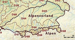
Alpine Foreland[2] and Alps
- D64 Iller-Lech Plateau[3] (04)
- D65 Lower Bavarian Uplands and Isar-Inn Gravel Plateau (05-06)
- Isar-Inn Gravel Plateau (05, Süden)
- Lower Bavarian Upland[3] (06, Middle and North)
- D66 Southern Alpine Foreland (03)
- D67 Swabian-Bavarian Foreland (02)
- D68 Northern Limestone Alps (01)
North and Baltic Seas
- D70 German Bight (excluding the Heligoland rock outcrop) (900 - to 90)
- D71 Dogger Bank and adjacent central North Sea (901 - to 90)
- D72 Western Baltic (902 - to 90)
- D73 Eastern Baltic (903 - to 90)
See also
References
- ^ Meynen (1959-62)
- ^ a b c d e f g h i j k l m n o p q r s t u v w x y z aa ab ac ad ae af ag ah ai aj ak al am an ao Elkins (1972).
- ^ a b c d e f g h i j k l m n o p q r s t u v w x y z aa ab ac ad ae af ag ah ai aj ak al am an ao ap aq ar as at au av Dickinson (1964).
Sources
- Dickinson, Robert E. (1964). Germany: A regional and economic geography (2nd ed.). London: Methuen. p. 84. ASIN B000IOFSEQ.
- Elkins, T.H. (1972). Germany (3rd ed.). London: Chatto & Windus, 1972. ASIN B0011Z9KJA.
- Incorporation of the old major geographical units 010-903 into the new natural regions D01-D73 by the BfN
- Meynen, Emil (Hrsg.) Handbuch der naturräumlichen Gliederung Deutschlands. Selbstverlag der Bundesanstalt für Landeskunde, Remagen 1953-1962 (Teil 1, enthält Lieferung 1-5), ISBN B0000BJ19E
- Meynen, Emil (Hrsg.) Handbuch der naturräumlichen Gliederung Deutschlands. Selbstverlag der Bundesanstalt für Landeskunde, Remagen 1959-1962 (Teil 2, enthält Lieferung 6-9), ISBN B0000BJ19F
- Ssymank, A. Neue Anforderungen im europäischen Naturschutz. Das Schutzgebietssystem Natura 2000 und die "FFH-Richtlinie der EU". – Zeitschrift „Natur und Landschaft“ Jg. 69. 1994, Heft 9: S. 395-406. Bonn-Bad Godesberg. ISSN 0028-0615
See also
External links
- BfN-Landschaftssteckbriefe (Description of Natural Regions under the old classification scheme)
- Interaktive Kartendienste des BfN ("Landscapes" map service based on the old system)
- Natural regions of Germany with major units (old and new system)
Categories:- Geography of Germany
- Regions of Europe
- Regions of Germany
- Geography-related lists
- Natural regions of Germany


Wikimedia Foundation. 2010.