- Muirhouses, Falkirk
-
Coordinates: 56°00′25″N 3°34′34″W / 56.007°N 3.576°W
Muirhouses 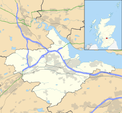
 Muirhouses
Muirhouses shown within the Falkirk council areaPopulation 235 [1] (2001 census) OS grid reference NT018680 - Edinburgh 15.4 mi (24.8 km) ESE - London 342 mi (550 km) SSE Council area Falkirk Lieutenancy area Stirling and Falkirk Country Scotland Sovereign state United Kingdom Post town BO'NESS Postcode district EH51 Dialling code 01506 Police Central Scotland Fire Central Scotland Ambulance Scottish EU Parliament Scotland UK Parliament Linlithgow and
East FalkirkScottish Parliament Central Scotland Falkirk East Website falkirk.gov.uk List of places: UK • Scotland • Muirhouses is a small village which lies in the Falkirk council area of Scotland. The village is located 1.1 miles (1.8 km) south-east of Bo'ness, 2.1 miles (3.4 km) north-northeast of Linlithgow and 8.0 miles (12.9 km) east of Falkirk. Muirhouses sits near to the south bank of the Firth of Forth close to the council boundary line between Falkirk and West Lothian councils.
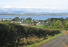
Access to the village can be gained from the south by the A993 road and from the north by the A904 road. At the time of the 2001 census the village had a population of 235 residents.[1]
References
- ^ a b No 3 - 2001 Census Population of settlements and wards www.falkirk.gov.uk. Retrieved 2011-05-02
Towns 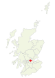
Villages Other villages Allandale · Avonbridge · Binniehill · Blackness · California · Dennyloanhead · Dunmore · Fankerton · Glensburgh · Greenhill · Haggs · Head of Muir · High Bonnybridge · Letham · Limerigg · Longcroft · Muirhouses · Reddingmuirhead · Rumford · Skinflats · South Alloa · Standburn · Stoneywood · Tamfourhill · Torwood · Wallacestone · Westquarter · WhitecrossCategories:- Villages in Falkirk council area
- Central Scotland geography stubs


Wikimedia Foundation. 2010.