- Ishbel Group
-
Ishbel Group
Stratigraphic range: Permian
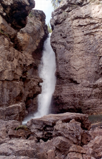
Calcareous siltstone exposed along the Johnston Creek west of BanffType Geological formation Underlies Spray River Group Overlies Tunnel Mountain Formation, Kananaskis Formation Thickness up to 427 metres (1,400 ft)[1] Lithology Primary Carbonate, sandstone Other Chert, siltstone Location Named for Mount Ishbel Named by A. McGugan, 1963 Region WCSB Country  Canada
The Ishbel Group is a stratigraphical unit of Permian age in the Western Canadian Sedimentary Basin.
It was first defined by A. McGugan in 1963.[2] It is named for Mount Ishbel of the Sawback Range, and parts of the group were first described in the vicinity of the mountain (Ranger Canyon, Johnston Canyon).
Contents
Lithology
The Ishbel Group is composed of carbonate, sandstone, chert and siltstone. [1]
Paleontology
The Ishbel Group was laid down under Phosphoria depositional conditions;[3] among the fossils that can be found are productid, chonetid and spiriferid brachiopods, omphalotrochid gastropod and edestid elasmobranch fish.
Distribution
The Ishbel Group reaches a maximum thickness of 427 metres (1,400 ft).[1] It occurs in the front ranges of the Canadian Rockies as far north as the Peace River.
Subdivisions
Sub-unit Age Lithology Max.
ThicknessReference Kindle Formation Asselian to early Artinskian siltstone, shale 200 m (660 ft) [4] Belloy Formation Permian carbonate and sandstone 274 m (900 ft) [5] Fantasque Formation Permian spicular chert, shale and siltstone 55 m (180 ft) [6] Mowitch Formation Roadian to Wordian sandstone with gypsum 76 m (250 ft) [7] Ranger Canyon Formation Roadian to Wordian dark chert, silicified sandstone, evaporite 30 m (100 ft) [8] Ross Creek Formation late Sakmarian to Artinskian shaly siltstone, calcareous siltstone, silty carbonate, phosphatic coquinas 143 m (470 ft) [9] Telford Formation Asselian to Sakmarian sandy limestone and dolomite 259 m (850 ft) [10] Johnston Canyon Formation late Sakmarian to Artinskian phosphate siltstone, calcareous siltstone and silty carbonate 57 m (190 ft) [11] Belcourt Formation Asselian to Sakmarian silty dolomite with chert 130 m (430 ft) [12] Relationship to other units
The Ishbel Group is disnconformably overlain by the Spray River Group and unconformably overlays the Tunnel Mountain Formation and the Kananaskis Formation in Kananaskis Country.[1]
It is equivalent to the Phosphoria Formation in Montana and Idaho.
References
- ^ a b c d Lexicon of Canadian Geologic Units. "Ishbel Group". http://cgkn1.cgkn.net/weblex/weblex_litho_detail_e.pl?00053:007039. Retrieved 2010-01-01.
- ^ McGugan, A., 1963. A Permian brachiopod and fusulinid fauna from Elk Valley, British Columbia, Canada. Journal of Paleontology, v. 37, p. 621-627.
- ^ Journal of Paleontology. "Biostratigraphy and faunas of the Permian Ishbel Group, Canadian Rocky Mountains". http://jpaleontol.geoscienceworld.org/cgi/content/abstract/42/5/1123. Retrieved 2010-01-10.
- ^ Lexicon of Canadian Geologic Units. "Kindle Formation". http://cgkn1.cgkn.net/weblex/weblex_litho_detail_e.pl?00053:007624. Retrieved 2010-01-09.
- ^ Lexicon of Canadian Geologic Units. "Belloy Formation". http://cgkn1.cgkn.net/weblex/weblex_litho_detail_e.pl?00053:001143. Retrieved 2010-01-09.
- ^ Lexicon of Canadian Geologic Units. "Fantasque Formation". http://cgkn1.cgkn.net/weblex/weblex_litho_detail_e.pl?00053:004826. Retrieved 2010-01-09.
- ^ Lexicon of Canadian Geologic Units. "Mowitch Formation". http://cgkn1.cgkn.net/weblex/weblex_litho_detail_e.pl?00053:010334. Retrieved 2010-01-09.
- ^ Lexicon of Canadian Geologic Units. "Ranger Canyon Formation". http://cgkn1.cgkn.net/weblex/weblex_litho_detail_e.pl?00053:012488. Retrieved 2010-01-09.
- ^ Lexicon of Canadian Geologic Units. "Ross Creek Formation". http://cgkn1.cgkn.net/weblex/weblex_litho_detail_e.pl?00053:012974. Retrieved 2010-01-09.
- ^ Lexicon of Canadian Geologic Units. "Telford Formation". http://cgkn1.cgkn.net/weblex/weblex_litho_detail_e.pl?00053:015017. Retrieved 2010-01-09.
- ^ Lexicon of Canadian Geologic Units. "Johnston Canyon Formation". http://cgkn1.cgkn.net/weblex/weblex_litho_detail_e.pl?00053:007213. Retrieved 2010-01-09.
- ^ Lexicon of Canadian Geologic Units. "Belcourt Formation". http://cgkn1.cgkn.net/weblex/weblex_litho_detail_e.pl?00053:001090. Retrieved 2010-01-09.
Western Canadian Sedimentary Basin Hydrocarbon history Depositional Regions Southern Alberta · Central Alberta · Northwestern Alberta Plains · South-central Canadian Rockies foothills · North-east Plains · North-central foothills · Liard River · Fort Nelson · Northern Rocky Mountains · Fort St. John · Saskatchewan · Western ManitobaLiard River Area Wapiti GRP (Kotaneelee FM · Dunvegan FM) · Ft. St. John GRP (Sully FM · SikanniFM · Lepine FM · Buckinghorse FM · Scatter FM · Garbutt FM) · Liard FM · Toad FM · Grayling FM · Ishbel GRP (Fantasque FM · Kindle FM) · Mattson FM · Golata FM · Debolt FM · Prophet FM · Besa River FM · Dunedin FM · Stone FM · Wokpash FM · Muncho-McConnell FM · Nonda FM · Kechica FM · Atan FM · Canadian ShieldCategories:- Stratigraphy of British Columbia
- Stratigraphy of the Northwest Territories
- Stratigraphy of Alberta
Wikimedia Foundation. 2010.