- Ralston Peak
-
Ralston Peak Elevation 9,235 ft (2,815 m) NGVD 29[1] Prominence 1,075 ft (328 m) [1] Location Location El Dorado County, California, USA Range Sierra Nevada Coordinates 38°50′00″N 120°06′06″W / 38.8332409°N 120.1015747°WCoordinates: 38°50′00″N 120°06′06″W / 38.8332409°N 120.1015747°W[2] Topo map USGS Echo Lake Climbing Easiest route class 1-2 Ralston Peak is a mountain in the Sierra Nevada mountain range to the west of Lake Tahoe within the Desolation Wilderness in El Dorado County, California. Ralston Peak is a very popular mountain to summit for the views of the wilderness area as it lies very near U.S. Route 50. The easiest trailhead to the summit can be found in Camp Sacramento a few miles west of Echo Summit.
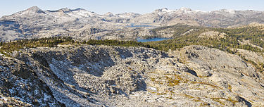 View of Lake Aloha from Ralston Peak
References
- ^ a b "Ralston Peak, California". Peakbagger.com. http://www.peakbagger.com/peak.aspx?pid=24121. Retrieved 2009-08-14.
- ^ "Ralston Peak". Geographic Names Information System, U.S. Geological Survey. http://geonames.usgs.gov/pls/gnispublic/f?p=gnispq:3:::NO::P3_FID:265157. Retrieved 2009-08-13.
External links
- "Mt. Ralston Peak". Trailspotting. http://www.trailspotting.com/2007/12/mt-ralston-peak.html. Retrieved 2009-08-14.
Categories:- Mountains of the Desolation Wilderness
- El Dorado County, California geography stubs

Wikimedia Foundation. 2010.