- Mount Maroon
-
Mount Maroon 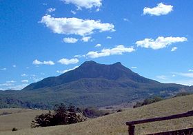
Mount MaroonElevation 966 m (3,169 ft) Location Location Queensland, Australia Range McPherson Range Mount Maroon is a mountain in South East Queensland that is part of the McPherson Range. The mountain rises to 966 m (3,169 ft) above sea level about 12 km west of Rathdowney.
The original indigenous name for the mountain was Wahlmoorum which meant sand goanna in the Yuggera language.[1] The current name for the mountain comes from the first grazing property in the area called Maroon.[2]
Mount Maroon consists mainly of rhyolite and has its geological origins in the cooling of molten rock beneath the surface.[1]
The mountain was first gazetted in 1938 as Mount Maroon National Park.[2] In 1950, Mount Barney National Park was extended to include Mount Maroon and nearby Mount May.[3] The mountain contains areas of montane heath vegetation, rocky pavement and mallee ash shrublands.[1][3]
Three rock climbers had to be rescued from the mountain in 2002.[4] In early 2008 a bull mastiff named Diff made headlines when it slipped over a ledge and had to be rescued via helicopter.[5] The dog, which was not permitted to be in the national park, led rescuers (by its barking) to two men who were stranded on a steep cliff ledge when trying to rescue the dog.
See also
References
- ^ a b c Environmental Protection Agency (Queensland). "Mount Barney: Nature, culture and history". The State of Queensland. https://www.epa.qld.gov.au/parks_and_forests/find_a_park_or_forest/mount_barney_national_park/mount_barney_mdash_nature_culture_and_history.html. Retrieved 2009-07-31.
- ^ a b Environmental Protection Agency (Queensland) (2000). Heritage Trails of the Great South East. State of Queensland. pp. 32–33. ISBN 0-7345-1008-X.
- ^ a b Mount Barney National Park: Visitor Information[brochure]. Queensland Parks and Wildlife Service. 2001. Environmental Protection Agency.
- ^ "Rock climbers winched to safety". ABC News Online. Australian Broadcasting Corporation. 2002-09-25. http://www.abc.net.au/news/newsitems/200209/s685241.htm. Retrieved 2009-07-31.
- ^ "Diff the dog safe and sound". The Age. The Age Company Ltd. 2008-01-03. http://www.theage.com.au/news/national/diff-the-dog-safe-and-sound/2008/01/03/1198949959040.html. Retrieved 2009-07-31.
Coordinates: 28°12′59″S 152°43′59″E / 28.21639°S 152.73306°E
Categories:- Mountains of Queensland
- Queensland geography stubs

Wikimedia Foundation. 2010.