- Mount Iō (Iōjima)
-
Mount Iō 硫黄岳 
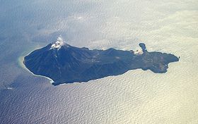
Aerial view of Iōjima with Mount Iō steaming.(February 2008)Elevation 703.7 m (2,309 ft) [1] Listing List of mountains and hills of Japan by height Translation Sulphur Mountain (Japanese) Location Location Iōjima, Kagoshima Prefecture, Japan Range Kikai Caldera Coordinates 30°47′35″N 130°18′19″E / 30.79306°N 130.30528°ECoordinates: 30°47′35″N 130°18′19″E / 30.79306°N 130.30528°E[1] Topo map Geographical Survey Institute, 25000:1 薩摩硫黄島, 50000:1 開聞岳 Geology Type Stratovolcano Age of rock Holocene Volcanic arc/belt Ryukyu arc Last eruption August-October 2004 Mount Iō (硫黄岳 Iō-dake) also Mount Iwo is an active rhyolitic lava dome on Iōjima in Kagoshima Prefecture, Japan. It sits within the borders of the town of Mishima.
The mountain is made up of non-alkali felsic rock and pyroclasitic flows.[2]
References
- ^ a b Geographical Survey Institute map 25000:1 薩摩硫黄島, last access 9 January 2009
- ^ "Kyushu". Seamless Digital Geographical Map of Japan. Geological Survey of Japan AIST. 2007. http://riodb02.ibase.aist.go.jp/db084/kihon/kyushu_e.xml. Retrieved 2009-01-13.
- Smithsonian Institution's Global Volcanism Program - Kikai
- VolcanoWorld - Kikai, Kyūshū, Japan
- Geographical Survey Institute
- S. Hamasaki, Volcanic-related alteration and geochemistry of Iwodake volcano, Satsuma-Iwojima, Kyushu, SW Japan, Earth Planets Space, pp 217–229, 2002, Tsukuba, Research Center for Deep Geological Environments, Geological Survey of Japan, AIST,
Categories:- Stratovolcanoes
- Volcanoes of Japan
- Active volcanoes
- Mountains of Kagoshima Prefecture
- Geology stubs
Wikimedia Foundation. 2010.
