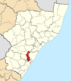
- Mkhambathini Local Municipality
-
Mkhambathini Local Municipality — Local municipality — Location in KwaZulu-Natal Country South Africa Province KwaZulu-Natal District UMgungundlovu District Seat Camperdown Area - Total 915.4 km2 (353.4 sq mi) Population (2007)[1] - Total 46,570 - Density 50.9/km2 (131.8/sq mi) - Households 11,970 Racial makeup[2] (2007) - Black African 93.35% - White 4.39% - Coloured 0.01% - Indian or Asian 2.25% Time zone SAST (UTC+2) Municipal code KZN226 Mkhambathini Local Municipality is an administrative area in the UMgungundlovu District of KwaZulu-Natal in South Africa. Mkhabathini is the isiZulu name for Table Mountain.[3]
Mkhambathini is well located in relation to Durban and Pietermaritzburg and adjoins Cato Ridge, a potential industrial node. The N3, which is identified in the Spatial Growth and Development Strategy as a provincial corridor, runs east west through the central part of the municipal area. [4]
References
- ^ "Community Survey, 2007: Basic Results Municipalities" (PDF). Statistics South Africa. http://www.statssa.gov.za/Publications/P03011/P030112007.pdf. Retrieved 2009-10-20.
- ^ "Community Survey 2007 interactive data". Statistics South Africa. http://www.statssa.gov.za/community_new/content.asp?link=interactivedata.asp. Retrieved 19 October 2009.
- ^ South African Languages - Place names
- ^ KwaZulu-Natal Top Business - Impendle Municipality
Province of KwaZulu-Natal, South Africa Provincial Capital: Pietermaritzburg Metropolitan
MunicipalitiesDistrict
and Local
MunicipalitiesVulamehlo · uMdoni · Umzumbe · uMuziwabantu · Ezingoleni · Hibiscus CoastEmnambithi-Ladysmith · Indaka · Umtshezi · Okhahlamba · ImbabazaneNewcastle · eMadlangeni · DannhauseruMhlabuyalingana · Jozini · The Big Five False Bay · Hlabisa · MtubatubaIngwe · Kwa Sani · Greater Kokstad · Ubuhlebezwe · UmzimkhuluCategories:- Local Municipalities of Umgungundlovu
Wikimedia Foundation. 2010.

