- Al Ahmadi Governorate
-
Al Ahmadi
الاحمدي— Governorate — Map of Kuwait with Al Ahmadi highlighted
Coordinates (Al Ahmadi): 29°04′37″N 48°05′02″E / 29.077°N 48.084°ECoordinates: 29°04′37″N 48°05′02″E / 29.077°N 48.084°E Country  Kuwait
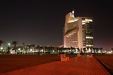
Capital Al Ahmadi Districts 11 Area - Total 5,120 km2 (1,976.8 sq mi) Population (2007-12-31) - Total 637,411 - Density 124.5/km2 (322.4/sq mi) Time zone EAT (UTC+03) ISO 3166 code KW-AH  The headquarters of Kuwait Petroleum Corporation (KPC) in Ahmadi.
Al Ahmadi (Arabic: الاحمدي) is one of the six governorates of Kuwait. It is located in the southern part of the country and is famous in Kuwait for its greenery and British architecture. Al Ahmadi forms an important part of Kuwaiti economy as several of Kuwait's oil refineries are located here. Main residential areas include Abu Halifa, Riqqah and Mangaf. Al Ahmadi is the home of several sporting clubs and complexes in Kuwait. The headquarters of Kuwait National Petroleum Company is located in Al Ahmadi.
Ahmadi, as it is popularly known was the home of the then KOC (Kuwait Oil Company).
It was also home to several thousand mostly British Ex-pats and their families from 1947 through to 1970, and possibly beyond. The original town layout was from an American pattern. Streets laid out at right angles to each other - 1st Street, 2nd Street and so on. At right angles were the avenues. The town was built on a slope facing the sea, which was about 7 miles (11 km) away. The street that ran across the top of the hill was called "main street". It housed the upper eschelons of the KOC. It ran down the hill in order of KOC rank. Within the town was the Hubara Club - a complex of buildings with a swimming pool, meeting rooms, restaurants, squash courts, tennis courts etc. Employees of the KOC would use this club every day to meet and chat. Their children spent most of their time here. Towards the bottom of the 'hill' was the 'souk' or shopping area; banks a cinema, which is now been closed down and a few shops.
Al Ahmadi consists of the following districts [1]:
- Abu Hleifa
- Al Ahmadi District
- Daher
- Fahaheel
- Fintas
- Hadyia
- Jaber Al Ali
- Mahboula
- Mangaf
- Reqqa
- Wafra
- Subahiya
Sports
References

Al Jahra Governorate Al Farwaniyah Governorate Mubarak Al-Kabeer Governorate 

Persian Gulf  Al Ahmadi Governorate

 Saudi Arabia
 Categories:
- Al Ahmadi Governorate
- Governorates of Kuwait
- Kuwait geography stubs
Wikimedia Foundation. 2010.
