- Middle Third (South Tipperary)
-
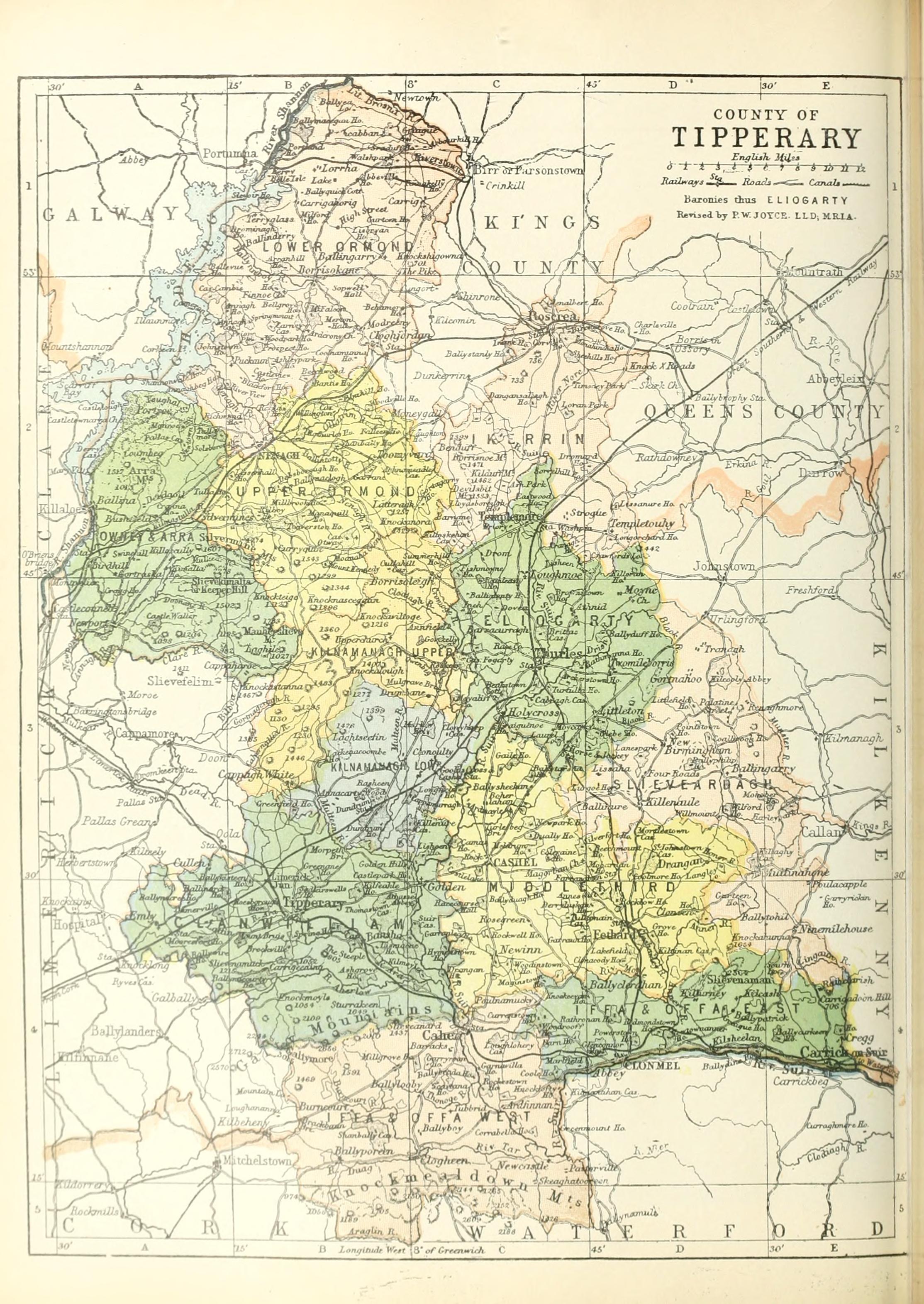
Middle Third (Irish: An Trian Meánach) is one of the baronies of Ireland, a historical geographical unit of land. Its chief town is Cashel. It is one of 14 baronies in the old county of Tipperary between Eliogarty to the north (whose chief town is Thurles), Iffa and Offa East to the south (whose chief town is Clonmel), Clanwilliam to the west (whose chief town is Tipperary) and Slievardagh to the east (whose chief town is Mullinahone). It is currently administered by South Tipperary County Council.
Contents
Legal context
Baronies were created after the Norman invasion as subdivisions of counties and were used for administration. While baronies continue to be officially defined units, they have been administratively obsolete since 1898. However, they continue to be used in land registration and specification such as in planning permissions. In many cases, a barony corresponds to an earlier Gaelic túath which had submitted to the Crown.
History
The history of the barony is also the history of the Kingdom of Munster which had Cashel for its capital. Later, the kingdom would be divided into northern and southern statelets.
Dynasts of Mumhan
The Éoganacht were a federation of tribes claiming a common lineage and spread throughout Munster. They were noted as kings of Munster from an early period until the rise of the Dal gCais in the 10th century. The main sub-tribes in the region of the barony were:
- Eóghanacht Chaisil (Cashel). Septs included MacCarthy, O'Sullivan, O'Callaghan.
- Éoganacht Beag Chaisil (Eoganacht Caille na Manach, in the barony of Kilnamanagh)
- Éoganacht Mhór Muman (about Knockgraffon, in the barony of Middle Third)
- Eóghanacht Airthir Chliach (Tipperary town district)
- Eóghanacht Durluis (in or near Thurles, in the barony of Eliogarty)
Dal gCais dynasty. The High King of Ireland, Brian Boru, fortified Cashel in 990. Murtagh O'Brien, King of Cashel, in presence of the chiefs and clergy, made a grant in 1101 of the "Rock" with the territory around it to O'Dunan, "noble bishop and chief senior of Munster". In 1127 Cormac III of Munster, King of Desmond, erected close to his palace on the "Rock" a church, now known as Cormac's Chapel, which was consecrated in 1134. By the Synod of Kells, 1152, Cashel became an archiepiscopal see. There are frequent references to "Tuadh Mumhan" in the Irish Annals beginning in the latter 11th century, but as a separate entity representing all of northern Munster an entry for the year 1118 seems to mark a milestone event. In that year, a treaty at Gleann Maidhir (Glanmire) divided the Kingdom of Munster into northern (Tuadh Mumhan) and southern (Des Mumhan) halves, a division apparently running near the border of modern counties Limerick and Cork. The entry in the Annals for 1118 reads, " A hosting by Toirdhealbhach Ua Conchobhair, king of Connacht, and by Murchadh O Maelsechlainn, king of Temhair, along with him, and by Aed O'Ruairc, into Mumha, as far as Glenn-Maghair; and he gave Des-Mumha to Mac Carthaigh, and Tuadh-Mumha to the sons of Diarmaid Ua Briain, and carried off the hostages of each."
Lordship of Ireland
With this 12th century division of Munster into two parts, Thomond included the area about the diocese of Killaloe, and additionally encompassed the traditional territorites of Úi Fidgeinti, Uí Chonaill Gabra, Eóghanacht Áine, Éile, Corco Mruadh, the tribes of Uaithne (later held by the Síl Cennétich, and much of Eóghanacht Caisel and Ciarraige Luachra.[1]
By the early 13th century, through the encroachment of the Anglo-Norman Butler family and others into eastern Thomond (north Tipperary, east Limerick and south Offaly), part of which came to be known as Ormond or East Munster, the kingdom of Thomond was greatly reduced.
Diocesan history
Various members of the Desmond and Ormond families became archbishops in the succeeding years up to the English Reformation. After a vacancy of six years Maurice FitzGibbon (1567–1578) a Cistercian abbot who belonged to the royal Desmond family, was promoted to the archbishopric by pope Pius V, but James MacCaghwell was put forward by Elizabeth I of England. Thus began the Anglican religion at Cashel. When the Penal Laws were sufficiently relaxed, the Roman Catholic archbishops returned openly to the see, but changed their residence and cathedra to Thurles.
Modern times
When County Tipperary was split into North and South Ridings in 1836, Middle Third was allocated to the south riding. However, the neighbouring barony of Kilnamanagh was split into Upper and Lower half-baronies, being allocated to the north and south ridings respectively.[2]
Towns, villages and townlands of the barony
Civil parishes of the barony
This table[3] lists an historical geographical sub-division of the barony known as the civil parish (not to be confused with an Ecclesiastical parish).
Name in Irish Name in English Ard Máil Ardmayle Baile an Ghraeigh Graystown Baile an Ráiligh Railstown Baile an tSeánaigh St. Johnstown Baile Bhriodúnach Peppardstown Baile na Madraí Dogstown Baile na Móna Mora Baile Uí Shíocháin Ballysheehan Bricín Brickendown Carraig Phádraig St. Patricksrock An Chathair Dhearg Redcity Cill Bhrácha Kilbragh Cill Cholmáin Colman Cill Chonaill Kilconnell Cill Teimhneáin Kiltinan Cillín an Stiabhnaigh Killeenasteena An Cluainín Cloneen Cnoc Rafann Knockgraffon An Chuailleach Cooleagh Cúil Mhondraí Coolmundry Daingean Deargáin Dangandargan Domhnach Mór Donaghmore Drongán Drangan Reilig Mhuire agus Áth Iseal Relickmurry and Athassel Fiodh Ard Fethard Gael Gaile Gráinseach an Bhairéadaigh Barrettsgrange Gráinseach Eoin Baiste Baptistgrange Maigh Gabhra Magowry Maigh gCorbáin Magorban An Mhainistir Liath Horeabbey Mainistir na Croiche Holycross Oireadh Erry Paróiste Eoin Baiste St. John baptist Ráth an Bhaightiúnaigh Boytonrath Ráth Cuala Rathcool Tulaigh Mheáin Tullamain Uachtar Rátha Outeragh Note: while the civil parish of Holycross straddles two baronies (Eliogarty and this baraony) and indeed two counties (North Tipperary and South Tipperary), the village itself and the abbey are entirly located in Eliogarty.
See also
- List of civil parishes of South Tipperary
External links
- Walsh, Dennis (2003). "Barony Map of Ireland". http://www.rootsweb.com/~irlkik/ihm/barony-map-ireland.htm. Retrieved 2007-02-13. Source given is "Ordnance survey".
References
- ^ Ancient Munster
- ^ Murphy, Donal A. (1994). The two Tipperarys: the national and local politics —devolution and self-determination— of the unique 1838 division into two ridings, and the aftermath. Regional studies in political and administrative history. 1. Relay. p. 71. ISBN 0946327149.
- ^ Database of Ireland - civil parishes.
Clanwilliam · Eliogarty · Iffa and Offa East · Iffa and Offa West · Ikerrin · Kilnamanagh Lower · Kilnamanagh Upper · Middle Third · Ormond Lower · Ormond Upper · Owney and Arra · Slievardagh ·
 Other baronies of Ireland: complete list · by countyCategories:
- County Tipperary geography stubs
- Baronies of South Tipperary
Wikimedia Foundation. 2010.