- Redfern to Chatswood railway line
-
Redfern to Chatswood Rail Link 
Mode Commuter rail
cancelledOwner Transport Infrastructure Development Corporation Key dates 2005 Line announced 2006 Corridors identified 2008 Project cancelled and partly superseded by the North West Metro 2008 North West Metro changed to CBD Metro 2010 CBD Metro cancelled and CBD Relief Line proposed instead The Redfern to Chatswood Rail Link (RCRL) was a component of the now-cancelled Metropolitan Rail Expansion Programme (MREP) in Sydney, Australia. First announced in 2005, the line was to have started at Redfern Station, travelled under the Central Business District, crossed under Sydney Harbour, passed through the lower North Shore and ended at the existing Chatswood railway station. It was to have provided the centre section of a planned North West-CBD-South West rail arc connecting major areas of employment with the CBD and airport. Alternative names for the planned route have included the "Redfern to Chatswood Harbour Rail Link", "MetroPitt" and the "CBD Rail Link". In March 2008 the State Government announced that the line would be cancelled, its role to be partly superseded by future metro rail lines.[1] In 2010 the CBD Relief Line & Western Express concept was announced. This is largely a return to the CBD Rail Link proposal, but uses a different alignment and links to different lines.
Contents
History
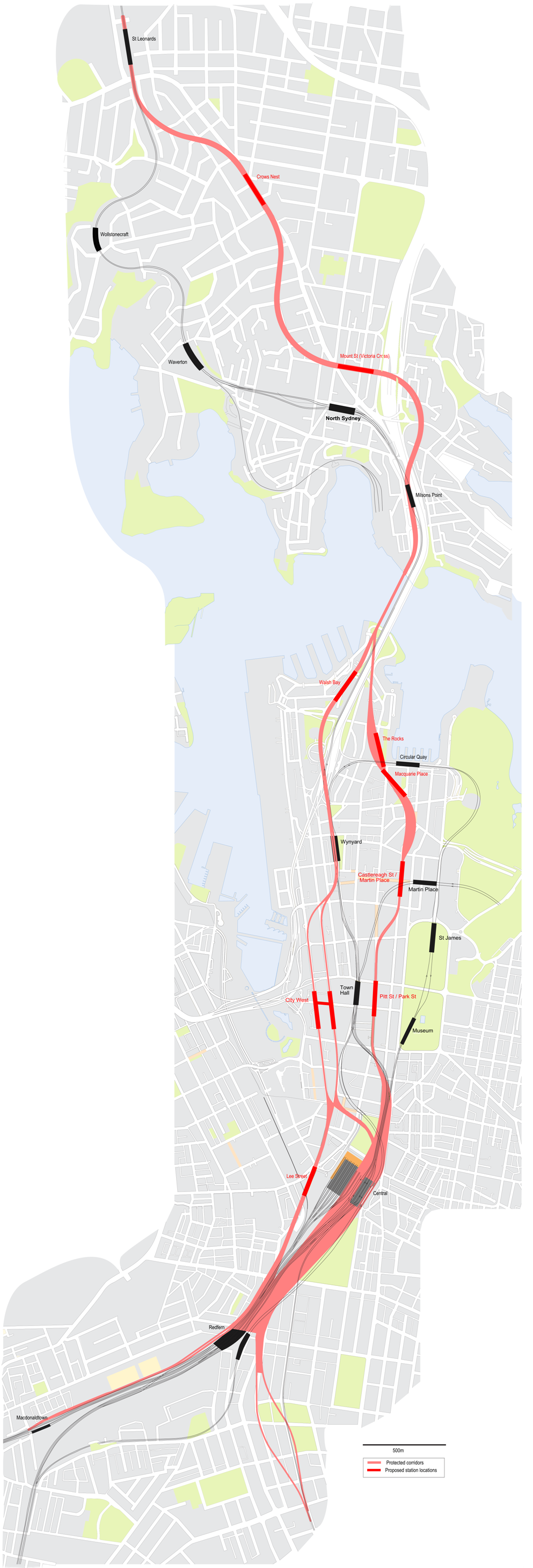
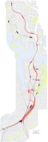 Protected corridors for the Metropolitan Rail Expansion Programme CBD Rail Link
The proposal was announced by Premier Bob Carr on 15 June 2005 (shortly before his resignation), and formed part of the $8 billion Metropolitan Rail Expansion Project (MREP). The MREP consisted of the New South Wales government's $8 billion North West - CBD - South West line, including the North West Rail Link (to extend from Cheltenham to Rouse Hill), and the spur to Leppington in Sydney's South West. The six kilometre RCRL was slated to cost $5 billion, and was to include duplicated tracks on the North Shore line between St Leonards and Chatswood. It was to provide a second railway line transversing Sydney Harbour to ease congestion at Town Hall and Wynyard stations, both considerably crowded and unable to be easily expanded, and to reduce travel times between the city and the lower North Shore.
The government's previous plan of constructing an additional CBD underground line was known as MetroWest. It was to have run from Haymarket in the city's Chinatown precinct near Darling Harbour, along the western edge of the city under Sussex or Kent Street and either ended at Wynyard station or continued over the harbour 'strapped' to the Sydney Harbour Bridge. This option would not have served the part of the city experiencing the fastest growth of employment, and would have necessitated the destruction of eight office buildings. A previous MetroPitt proposal, travelling further east (and under its namesake Pitt Street) and through the financial district, could also be built deeper underground, limiting the impact on existing infrastructure.
In 2006, both of these corridors were protected with planning buffers to allow the option of future construction.[2] Developers who want to excavate deeper than two metres within a 25-metre buffer zone of the corridors need to seek RailCorp's approval.[3]
Proposed stations
In the plan the stations along the RCRL would have included:[4]
- Redfern
- Central - interchanging with all lines through the CBD
- Pitt Street
- Martin Place - interchanging with the Eastern Suburbs & Illawarra Line
- Circular Quay - interchanging with the Bankstown, Inner West, South & Airport/East Hills Lines
- Victoria Cross
- Crows Nest
- St Leonards - interchanging with the North Shore and Northern Lines
- Artarmon
- Chatswood - interchanging with the North Shore and Northern Lines
A map[5] of the protected corridors suggested there may have been the potential for another station at Macquarie Place, between The Rocks and Castlereagh Street.
Notes
- ^ Besser L and Smith A. City catches fast-tracked metro. Sydney Morning Herald, 19 March 2008.
- ^ "Iemma Government locks in future city rail corridors". Sydney Metropolitan Strategy. NSW Government - Department of Planning. 2006-02-18. Archived from the original on 2006-11-11. http://web.archive.org/web/20061111114138/http://www.metrostrategy.nsw.gov.au/dev/ViewPage.action?siteNodeId=59&languageId=1&contentId=457. Retrieved 2007-01-24.
- ^ "Rail routes sealed off". Hill Shire Times. 2006-02-20. http://www.hillsshiretimes.com.au/article/2006/02/20/91_news_pf.html. Retrieved 2007-01-24.
- ^ "Revealed: the harbour tunnel to ease rail crisis". The Sydney Morning Herald. 2005-06-09. http://www.smh.com.au/news/national/revealed-the-harbour-tunnel-to-ease-rail-crisis/2005/06/08/1118123901385.html. Retrieved 2007-01-24.
- ^ "Protected CBD Rail Corridors Map" (PDF). Sydney Metropolitan Strategy. NSW Government - Department of Planning. Archived from the original on 2006-12-12. http://web.archive.org/web/20061212033553/http://www.metrostrategy.nsw.gov.au/dev/digitalAssets/1621_1143781831174_cbdrail.pdf. Retrieved 2007-01-24.
See also
- SydneyLink
- Proposed railways in Sydney
External links
- Sydney Metropolitan Strategy, Department of Planning information and map
- Satellite image of the proposed MetroPitt route, originally prepared by The Sydney Morning Herald
- Rail Link website
Railway Lines in New South Wales 
Main lines Broken Hill Line · Main North Line · Main South Line · Main West Line · North Coast Line · South Coast Line
Country branch lines Berrima Line • Binnaway-Werris Creek Line • Blayney-Demondrille Line • Boggabilla Branch • Bombala Line • Canberra Branch • Cobar Branch • Coonamble Branch • Grenfell Branch • Gwabegar Line • Hay Branch • Lake Cargelligo Branch • Medway Quarry Branch • Mungindi Line • Naradhan Branch • Newcastle branch • Oaklands Branch • Parkes to Narromine Line • Picton - Mittagong loop • Pokataroo Branch • Sandy Hollow - Gulgong Line • South Maitland Railway • Stockinbingal - Parkes Line • Temora to Roto Line • Tottenham Branch • Troy Junction - Merrygoen Line • Unanderra - Moss Vale Line • Walgett Branch • Warren Branch • Yanco - Griffith Line
Closed: Ballina line • Barraba line • Belmont line • Boorowa branch • Brewarrina Line • Burcher Branch • Camden Branch • Captains Flat Branch • Corowa Branch • Crookwell line • Dorrigo Line • Eugowra branch • Holbrook Branch • Kunama (Batlow) Branch • Kywong Branch • Merriwa line • Molong to Dubbo line • Morpeth line • Mount Hope line • Murwillumbah Branch • Newnes line • Oberon Line • Rand Branch • Rankins Springs Branch • Richmond Vale Railway • Taralga Branch • Tocumwal line • Toronto Line • Tumbarumba Line • Tumut Branch •Wallsend Branch • Westby Branch
Sydney lines Main Suburban Line • City Circle
Airport Line • Bankstown Line • Carlingford Line • Cumberland Line • Cronulla Line • Eastern Suburbs Line • East Hills Line • Epping to Chatswood Line • Illawarra Line • Inner West Line • North Shore Line • Northern Line • Olympic Park Line • Richmond Line • South Line • Western Line
Goods only: Metropolitan Goods Line • Southern Sydney Freight Line
Closed: Camden Line • Kurrajong Line • Rogans Hill Line • Ropes Creek Line • Royal National Park Line • Sandown Line
Interurban and regional passenger services Blue Mountains Line • Hunter Lines • Newcastle & Central Coast Line • South Coast Line • Southern Highlands Line
Proposed or under construction Tourist & heritage railways Glenreagh Mountain Railway • Lachlan Valley Railway • Richmond Vale Railway • Skitube • Zig Zag Railway
Categories:- Underground rapid transit in Australia
- Railway lines in Sydney
Wikimedia Foundation. 2010.