- McArthur River uranium mine
-
This article is about the uranium mine in Canada. For the lead-zinc Mine in Australia, see McArthur River zinc mine. For other uranium mines in the McArthur Basin in the Northern Territory of Australia, see Ranger Uranium Mine.
McArthur River Uranium Mine 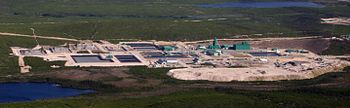
Aerial view of the mine site.Location Location in Saskatchewan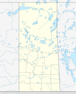
 McArthur River Uranium Mine
57°45′45″N 105°03′07″W / 57.7625°N 105.05194°WCoordinates: 57°45′45″N 105°03′07″W / 57.7625°N 105.05194°W
Location Athabasca Basin Province Saskatchewan Country Canada Owner Company Cameco(70%) and AREVA(30%) Year of acquisition 1988 (Discovery) Production Products Uranium History Opened 2000 The McArthur River Uranium Mine, in northern Saskatchewan, Canada, is the world's largest high-grade uranium deposit.
The McArthur River deposit was discovered in 1988. The property is located 620 air kilometres north of Saskatoon, Saskatchewan and 80 kilometres northeast of the Key Lake mill in the uranium rich Athabasca Basin. Mine construction began in 1997, with production commencing in 1999. The mine achieved full commercial production in November 2000. Production is regulated at 18.7 million pounds of yellowcake a year with the ore being processed through the Key Lake mill.
Reserves
As of December 31, 2009, the mine has proven and probable reserves of 778,500 tonnes at an average grade of 19.53% U3O8.[1] (335.2 Million pounds)
Awards
The McArthur River mine has been awarded the Canadian Institute of Mining, Metallurgy and Petroleum's John T. Ryan Trophy for the best safety record for metal mines several times. This award is given to the metal mine with the best safety record for the previous year.
National Trophy
- 2000
- 2010
Regional Trophy - Prairies and Northwest Territories
- 2011
Ownership
The mine is owned by Cameco Corporation (70%) and AREVA Resources Canada Inc (30%), formerly COGEMA Resources Inc. Cameco is the mine operator.
Access
The mine is serviced by the McArthur River Airport to the northeast. It is also connected to the south by road. According to Google Maps, this road is Saskatchewan Highway 914, however the official 2011 highway map of Saskatchewan indicates that 914 terminates at the Key Lake mine, with the road that continues to McArthur not actually on the map.
See also
References
- ^ "Financial Reporting - Reserves". Cameco Corporation. http://www.cameco.com/investors/financial_reporting/reserves/. Retrieved 2010-03-20.
External links
- "McArthur River". Cameco Corporation. http://www.cameco.com/mining/mcarthur_river/.
- "McArthur River/Key Lake". AREVA. http://www.cri.ca/uranium/mcarthur.html.
Categories:- Uranium mines in Canada
- Mines in Saskatchewan
- Underground mines in Canada


Wikimedia Foundation. 2010.