- Matugga
-
Matugga Matugga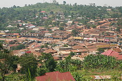 Map of Uganda showing the location of Matugga.
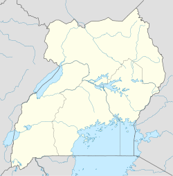
 Matugga
Coordinates: 00°27′37″N 32°31′44″E / 0.46028°N 32.52889°E Country  Uganda
Region Central Uganda District Wakiso District County Gombe Constituency Kyaddondo North Population (2010 Estimate) - Total 15,000 Time zone EAT (UTC+3) Matugga is a town in Central Uganda. It is one of the urban centers in Wakiso District. The correct phonetic spelling of the town is with two "g"s.
Contents
Location
The town is situated on the tarmacked, all-weather Kampala-Masindi Highway. Matugga is located approximately 21 kilometres (13 mi), by road, north of Kampala, Uganda's capital and largest city.[1] The coordinates of the town are:00 27 37N, 32 31 44E (Latitude:0.4603; Longitude:32.5287).
Overview
Matugga is the starting point of the Matugga-Kapeeka Road, a 42 kilometres (26 mi) gravel road connecting the towns of Matugga, Gombe, Semuto and Kapeeka. The highway traverses Wakiso District and Nakaseke District.
The road will be upgraded from gravel to bitumen at an estimated cost of US$20 million. 65% of the funding will be provided by the Government of Uganda, while 35% will be provided by the Nordic Development Fund. The work will be carried out by China Tonguing International Construction Corporation (CICO). COWI, a Danish Consultancy firm will supervise the work. Construction is expected to be completed in late 2010.[2]
Population
The exact population of Matugga is not known at this time. In 2010, the town's population was estimated at approximately 15,000, of whom about 60% were children below 18 years.[3] However, the Electoral Commission for general election in 2011 had registered over 8,500 voters (citizens of Uganda over 18 years old) for five polling station located in Matugga. [4]
Landmarks
The landmarks within the town limits or close to the edges of town include:
- The offices of Matugga Town Council
- Matugga Central Market
- Busaawa-Mmanze Health Centre - A Community Health Center administered by MACERUDET, a local NGO[5]
- The Revival Life Center - A complex with a 450-pupil primary school, a 200-pupil secondary school and a 150-pupil orphanage administered by Pastor Ivan Lugoloobi of Revival Ministries a Pentecostal Church[6]
- Catholic Centre - A Catholic Church Centre with St. Charles Lwanga Primary School administered by the Franciscan order of Greyfriars[7]
- Ladybird School - An 80-pupil elementary boarding school administered affiliated with Ingleton Middle School in Ingleton, North Yorkshire, United Kingdom.[8]
External links
See also
- Gombe
- Kapeeka
- Semuto
- Buganda Kingdom
- Wakiso District
- Central Region, Uganda
References
- ^ Road Distance between Kampala and Matugga with Map
- ^ About the Matugga-Kapeeka Road
- ^ Matugga With Population of About 15,000 In 2010
- ^ The Electoral Commission Uganda
- ^ About Mmanze Center for Rural Development and Training
- ^ About The Revival Life Center
- ^ About St. Francis Catholic Centre
- ^ About Ladybird School, Matugga
 Wakiso District
Capital: Wakiso Counties and
sub-countiesKyaddondo County · Busiro County
Parishes Towns and villages Banda · Buddo · Buloba · Entebbe · Kira · Bweyogerere · Kireka · Kirinnya · Namugongo · Kyaliwajjala · Kasangati · Katalemwa · Gayaza · Gombe · Nakweero · Matugga · Wakiso · Kakiri · Nansana · Kajjansi · Sentema · Lubowa · Lweeza · Namulonge · Naalya · Najjera · Namanve · Nsangi · Kyengera · Nabbingo · KisubiEconomy Uganda Clays Limited · Roofings Limited · Uganda Civil Aviation Authority · Bank of Africa · Barclays Bank · Centenary Bank · Crane Bank · Ecobank · Equity Bank · Fina Bank · Orient Bank · PostBank Uganda · Uganda Finance Trust Limited · Stanbic Bank · Kingstone Enterprises Limited · Ugachick Limited · Namanve Power Station · Kampala Industrial and Business Park · Chrysanthemums Uganda LimitedNotable landmarks Old Entebbe Town · Entebbe Botanical Gardens · State House Entebbe · Entebbe-Kampala Highway · Lake Victoria · Kasubi Tombs · Mandela National Stadium · Imperial Botanical Beach Hotel · Imperial Resort Beach Hotel · Imperial Golf View Hotel · Uganda Martyrs Basilica · Banda Kabaka's Palace · Kireka Kabaka's Palace · Bulago Resort Island · Ngamba Island · Lake Victoria Serena ResortTransport Entebbe International Airport · Kajjansi Airport · Namulonge Airport · Kampala-Jinja Highway · Gayaza-Ziroobwe Road · Matugga-Kapeeka Road · Kampala Northern Bypass Highway · Entebbe-Kampala HighwayEducation Uganda Martyrs High School Namugongo · Gayaza High School · King's College Budo · St. Mary's College Kisubi · Trinity College Nabbingo · African Bible College (Uganda) · Nkumba UniversityNotable people Categories:- Wakiso District
- Populated places in Uganda
- Central Region, Uganda


Wikimedia Foundation. 2010.