- Marneuli District
-
 Marneuli District
Marneuli (Georgian: მარნეულის მუნიციპალიტეტი - Marneulis Munitsipaliteti) is a district of Georgia, in the region of Kvemo Kartli. Its main town is Marneuli.
Contents
Location
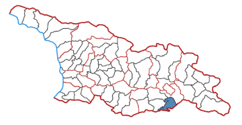
Marneuli District is situated in south-east part of country near to border with Azerbaijan and Armenia. Area of district amounts 935 km² [1]. Most part of its territory is located in Marneuli lowland (between 350-600 meters above sea level). Highest point is Garadagh mount (1416 m.)
Administrative division
Marneuli District consists of 2 city (Marneuli and Shulaveri) and 72 villages. Largest villages are Sadakhlo and Kizilajlo. In 51 villages predominate ethnic Azeris, in 11 – Armenians, in 8 – Georgians and in 1 – Greeks [2].
Demography
According to Georgian Statistics Department at the beginning of 2009 population of Marneuli District was 123.5 th. or 2,8% of total population of Georgia. 49,4% of inhabitants are males, 50,6% females [3]. In accordance with population census in 2002 Azeris have been predominating with 83.1% at the ethnic structure of inhabitants. Georgians was 8% and Armenians 7.9% [4].
Economy
After the collapse of Soviet Union economy of Marneuli has broken down like other regions of country. At present Marneuli is known as agricultural region. In 2006 Marneuli owned share 78% of tobacco, 11% of vegetables and 4% of meat production around the Georgia[5].
Culture
At present in Marneuli it is functioning 87 state and 1 non-state secondary school, 4 college, 4 high education enterprises (university), 67 libraries, 2 theaters, 2 museums and 1 TV [6].
References
- ^ http://www.statoids.com/yge.html
- ^ Rural population of Georgia (in Georgian language)[dead link]
- ^ Population by municipalities for the beginning of the year in Georgia[dead link]
- ^ Summary of population census 2002 in Georgia (in Georgian language)[dead link]
- ^ http://www.statistics.ge Statistics Department of Georgia
- ^ http://www.kvemokartli.gov.ge Official site of Kvemo Kartli mkhare
Autonomous Republic of Abkhazia Autonomous Republic of Adjara Guria Imereti Kakheti Mtskheta-Mtianeti Racha-Lechkhumi and Kvemo Svaneti Samegrelo-Zemo Svaneti Poti · Abasha · Zugdidi · Martvili · Mestia · Senaki · Chkhorotsku · Tsalenjikha · Khobi · Zemo AbkhaziaSamtskhe-Javakheti Kvemo Kartli Shida Kartli Categories:- Districts of Kvemo Kartli

Wikimedia Foundation. 2010.