- Maritime delimitation between Romania and Ukraine
-
 The maritime boundary lines claimed by Romania and Ukraine.
Maritime delimitation between Romania and Ukraine in the Black Sea was conducted by the International Court of Justice. On September 16, 2004 the Romanian side brought a case to the Court following unsuccessful bilateral negotiations. On February 3, 2009 the Court revealed its verdict, in which it established a single maritime boundary delimiting the continental shelf and exclusive economic zones of Romania and Ukraine.
Contents
Preposition
In 1997, Romania and Ukraine signed a treaty in which both states "reaffirm that the existing border between them is inviolable and therefore, they shall refrain, now and in future, from any attempt against the border, as well as from any demand, or act of, seizure and usurpation of part or all the territory of the Contracting Party".[1] However, both sides have agreed that if no resolution on maritime borders can be reached within two years, then either side can go to the International Court of Justice to seek a final ruling.
Oil (10 million tonnes) and natural gas deposits (1 billion m³) were discovered under the seabed nearby.[when?] The natural resources are not significant though, as they can be exhausted in 2–3 years of development.
BP and Royal Dutch/Shell signed prospect contracts with Ukraine, while Total with Romania. Austrian OMV (the owner of Romania's largest oil company, Petrom) also signed a contract with Naftogas of Ukraine and Chornomornaftogaz to jointly participate to an auction for a concession of the area.
Snake Island location
Due to its geographic position, Snake Island status dramatically affects the maritime frontier line between the two countries. If Snake Island is an island, then continental shelf around Snake Island should be considered as Ukrainian water. If Snake Island is not an island, but a cliff, then in accordance with international law the maritime boundary between Romania and Ukraine should be drawn without taking into consideration the isle location.
The Romanian side claimed that Ukraine was developing Snake Island in order to prove its island status as contrary to a cliff.[citation needed]
Court hearings
On 16 September 2004 the Romanian side brought a case against Ukraine to the International Court of Justice in a dispute concerning the maritime boundary between the two States in the Black Sea, claiming that the island has no socio-economic significance.[2]
In general, the islands are “special” or “relevant” circumstances to be considered in each act of delimitation effected either by states themselves or with the help of a third party, such as the ICJ, and depending on the peculiarity of a given situation, considerations of equity may lead to giving islands full, partial or even no effect in determining entitlement to maritime areas.
However, in the practice of states even rocks are often given effect during maritime delimitation, leaving alone full-fledged islands. For example, Aves Island was given full effect in the United States – Venezuela Maritime Boundary Treaty despite its very small size and lack of habitation. Furthermore, most states do not distinguish the islands from LOSC Art. 121(3) “rocks” and claim the shelf and the EEZ for all their rocks and islands. Examples would include the UK (with regard to Rockall Island), Japan (with regard to Okinotorishima), the US (with regard to Hawaiian and many other uninhabited islands along the equator), France (with regard to Clipperton and other islands), Norway (with regard to Jan Mayen), Yemen, Nicaragua, Sri Lanka etc.
The practice of international courts, tribunals and other third-party dispute settlement bodies is less uniform. On the one hand, even alleged Art.121(3) “rocks” are taken into account in delimiting the maritime boundaries. On the other hand, even though the islands are not Art.121(3) “rocks”, they may well be either ignored or substantially discounted (enclaved or eliminated) if their use would have an inequitable distorting effect in light of their size and location. Even if such islands are not discounted their actual influence on the delimitation is often minimal. All these decisions cannot, however, be said to have reached that level of uniformity in order to become a rule of law.
Although there have as well been some other instances where the issue, similar to that between Ukraine and Romania, was directly or implicitly involved, there has not been so far any direct third-party international review of whether a particular feature is LOSC Art.121(3) “rock” or is Art.121(2) “island”. Therefore, the Romanian-Ukrainian dispute may be the first case where the question of whether or not the island constitutes a “rock” with all the following implications under LOSC Art. 121(3) after its adoption will be examined by the main international adjudicative forum.
The decision of the ICJ in this case was not, therefore, that easy to predict. Even if the ICJ declares Snake Island to be an “island”, in delimiting the maritime zones, the ICJ may take into account “special” or “relevant” circumstances (the fact that the Black Sea is the “enclosed or semi-enclosed sea” which would make the maritime delimitation more difficult, the presence of the Serpents’ island, its location, significance etc.) and give the Serpents’ Island either full, or some, or none effect at all.
On September 19, 2008, the court concluded public hearings.[3][4]
Court decision
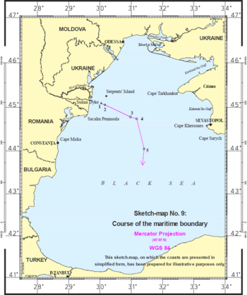 Course of the maritime boundary as established by the Court in its Judgment.
The court delivered its judgment on February 3, 2009,[5] which divided the sea area of the Black Sea along a line which was between the claims of each country.
On the Romanian side, the Court found that the landward end of the Sulina dyke, not the manmade end should be used as a base point for the establishment of the provisional equidistance line. The Court noted that the functions of a dyke are different from those of a port, and only harbor works are regarded as forming part of the coast.[6]
On the Ukrainian side, the Court found that Snake Island cannot be taken to form part of Ukraine’s coastal configuration. The Court explained that "to count Serpents’ Island as a relevant part of the coast would amount to grafting an extraneous element onto Ukraine’s coastline; the consequence would be a judicial refashioning of Geography" The court concluded that Snake Island "should have no effect on the delimitation in this case, other than that stemming from the role of the 12-nautical-mile arc of its territorial sea".[6]
While the judgment draws an equitable line between both parties, Romania got a larger chunk of the disputed area, allowing it to exploit 80%[dubious ] of estimated 100 billion cubic meters of natural gas deposits and 15 million tonnes of petrol located underneath the seabed.[7] Although according to Ukraine's commissioner in the UN International Court Volodymyr Vasylenko almost the whole of oil and gas reserves are concentrated in the part of the sea shelf going to Ukraine.[8]
Ukrainian President Viktor Yuschenko considers the ruling "just and final" and hoped "the ruling opens new opportunities for further fruitful cooperation in all sectors of the bilateral cooperation between Ukraine and Romania".[9]
References
- ^ Romania - Ukraine Treaty (1997) is available in Romanian and English in the materials submitted by Romania to the International Court of Justice [1], and is available in Ukrainian from the Ukrainian parliament website [2].
- ^ "Romania brings a case against Ukraine to the Court in a dispute concerning the maritime boundary between the two States in the Black Sea" (PDF). International Court of Justice. September 16, 2004. http://www.icj-cij.org/docket/files/132/1707.pdf.
- ^ "Conclusion of the public hearings - Court begins its deliberation" (PDF). International Court of Justice. September 19, 2008. http://www.icj-cij.org/docket/files/132/14755.pdf.
- ^ "Maritime Delimitation in the Black Sea (Romania v. Ukraine)
- ^ "The Court establishes the single maritime boundary delimiting the continental shelf and exclusive economic zones of Romania and Ukraine". International Court of Justice. February 3, 2009. http://www.icj-cij.org/docket/files/132/14985.pdf.
- ^ a b "Case Concerning Maritime Delimitation in the Black Sea (Romania v. Ukraine). Judgment". International Court of Justice. February 3, 2009. http://www.icj-cij.org/docket/files/132/14987.pdf.
- ^ EU's Black Sea border set in stone, EUobserver, February 3, 2009
- ^ Ukraine gets bulk of oil, gas reserves in delimitation dispute with Romania, says commissioner to international court, Interfax-Ukraine (February 3, 2009)
- ^ Yuschenko: UN International Court Of Justice's Decision On Delimitation Of Black Sea Shelf Between Ukraine And Romania Just, Ukrainian News Agency (February 5, 2009)
See also
 Foreign relations of Ukraine
- European Union
- NATO
Africa - Algeria
- South Africa

Americas - Brazil
- Canada
- United States
Asia Europe EUOtherDisputes - Russia–Ukraine gas disputes
- Transnistria border dispute
- Romania–Ukraine maritime delimitation
Related topics  Foreign relations of Romania
Africa 
Americas Asia Middle EastPalestine · Saudi ArabiaElsewhereChina · Malaysia · Pakistan · Philippines · UzbekistanEurope Armenia · Azerbaijan · Bosnia and Herzegovina · Bulgaria · Denmark · Greece · Hungary · Ireland · Lithuania · Moldova · Norway · Poland · Russia · Serbia · Slovakia · Slovenia · Spain · Switzerland · Turkey · Ukraine · United Kingdom · Vatican CityDisputes Romania–Ukraine maritime delimitationRelated topics Ministry of Foreign Affairs · Diplomatic missions of / in Romania · Romanian diaspora · Romanian diplomatsRomanian Ministry of Foreign Affairs Categories:- International Court of Justice cases
- Territorial disputes of Ukraine
- Disputed waters
- History of the foreign relations of Romania
- Territorial disputes of Romania
- Maritime history of Romania
- Romania–Ukraine border
- 2009 in international relations
- 2009 in case law
- 2009 in Romania
- 2009 in Ukraine


Wikimedia Foundation. 2010.