- Mansky District
-
Mansky District (English)
Манский район (Russian)
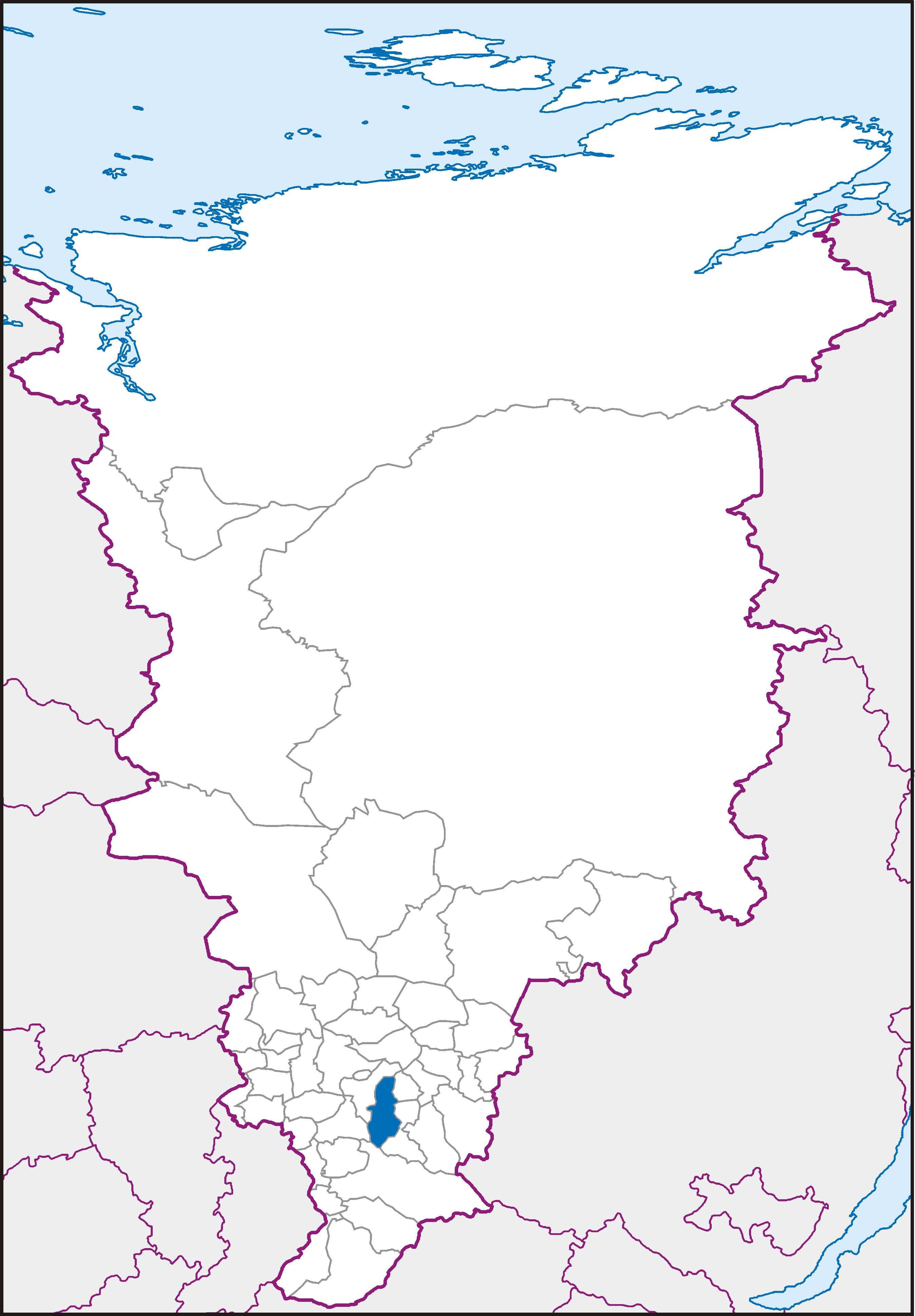
Location of Mansky District on the map of Krasnoyarsk Krai
Coat of arms Flag Administrative status (as of 2010) Country Russia Federal subject Krasnoyarsk Krai[1] Administrative center selo of Shalinskoye[1] # of selsoviets 11[2][1] # of rural localities 45[2][1] Municipal status (as of January 2009) Municipally incorporated as Mansky Municipal District[3] - Head[2] Yury V. Mrachek[2] - Representative body Mansky District Council of Deputies[2] - # of rural settlements 11[4] Statistics Area 5,976 km2 (2,307 sq mi)[2] Population (2010 Census,
preliminary)16,072 inhabitants[5] Population (2002 Census) 18,618 inhabitants[6] - Urban population 0% - Rural population 100% Density 3 /km2 (7.8 /sq mi)[7] Time zone KRAST (UTC+08:00)[8] Established April 4, 1924[2] District newspaper Manskaya zhizn (Mansky Life)[9] Official website Mansky District (Russian: Ма́нский райо́н) is an administrative and municipal district (raion), one of the forty-three in Krasnoyarsk Krai, Russia. It is located in the central portion of the krai and borders with Beryozovsky District in the north and northwest, Uyarsky District in the northeast, Partizansky District in the southeast, Kuraginsky District in the south, and Balakhtinsky District in the southwest. The area of the district is 5,976 square kilometers (2,307 sq mi).[2] Its administrative center is the rural locality (a selo) of Shalinskoye.[1] Population: 16,072 (2010 Census preliminary results);[5] 18,618 (2002 Census);[10] 21,888 (1989 Census).[11] Population of Shalinskoye accounts for 22.9% of the district's population.[10]
Contents
Geography
Mansky District is situated in the Mana River valley. It stretches for 197 kilometers (122 mi) from north to south.
 Entrance to Bolshaya Oreshnaya Cave
Bolshaya Oreshnaya Cave, the second longest-stretching cave in Russia, is located on the district's territory. Other notable caves include Tyomnaya, Ledyanaya, Belaya, and Medvezhya, which comprise the Badzheyskiye Caves nature sanctuary of regional importance—a protected area of inanimate nature and a habitat of rare species.[12]
History
The district was founded on April 4, 1924.[2]
Divisions and government
Administratively, the district is divided into eleven selsoviets, which are municipally incorporated as rural settlements. The Head of the District is Yury V. Mrachek and the Chairman of the District Council is Alevtina V. Girenkova.[2] As of 2010, the District Council consists of twenty deputies.[13]
References
- ^ a b c d Государственный комитет Российской Федерации по статистике. Комитет Российской Федерации по стандартизации, метрологии и сертификации. №ОК 019-95 1 января 1997 г «Общероссийский классификатор объектов административно-территориального деления. Код 04», в ред. изменения №168/2011 от 1 октября 2011 г. (State Statistics Committee of the Russian Federation. Committee of the Russian Federation on Standardization, Metrology, and Certification. #OK 019-95 January 1, 1997 Russian Classification of Objects of Administrative Division . Code 04, as amended by the Amendment #168/2010 of October 1, 2011. ).
- ^ a b c d e f g h i Official website of Krasnoyarsk Krai. Information about Mansky District (Russian)
- ^ Law #13-2864, Article 2
- ^ Law #13-2864, Article 1
- ^ a b Федеральная служба государственной статистики (Federal State Statistics Service) (2011). "Предварительные итоги Всероссийской переписи населения 2010 года (Preliminary results of the 2010 All-Russian Population Census)" (in Russian). Всероссийская перепись населения 2010 года (All-Russia Population Census of 2010). Federal State Statistics Service. http://www.perepis-2010.ru/results_of_the_census/results-inform.php. Retrieved 2011-04-25.
- ^ Федеральная служба государственной статистики (Federal State Statistics Service) (2004-05-21). "Численность населения России, субъектов Российской Федерации в составе федеральных округов, районов, городских поселений, сельских населённых пунктов – районных центров и сельских населённых пунктов с населением 3 тысячи и более человек (Population of Russia, its federal districts, federal subjects, districts, urban localities, rural localities—administrative centers, and rural localities with population of over 3,000)" (in Russian). Всероссийская перепись населения 2002 года (All-Russia Population Census of 2002). Federal State Statistics Service. http://www.perepis2002.ru/ct/doc/1_TOM_01_04.xls. Retrieved 2010-03-23.
- ^ The value of density was calculated automatically by dividing the 2010 Census population by the area specified in the infobox. Please note that this value may not be accurate as the area specified in the infobox does not necessarily correspond to the area of the entity proper or is reported for the same year as the population.
- ^ Правительство Российской Федерации. Постановление №725 от 31 августа 2011 г. «О составе территорий, образующих каждую часовую зону, и порядке исчисления времени в часовых зонах, а также о признании утратившими силу отдельных Постановлений Правительства Российской Федерации». Вступил в силу по истечении 7 дней после дня официального опубликования. Опубликован: "Российская Газета", №197, 6 сентября 2011 г. (Government of the Russian Federation. Resolution #725 of August 31, 2011 On the Composition of the Territories Included into Each Time Zone and on the Procedures of Timekeeping in the Time Zones, as Well as on Abrogation of Several Resolutions of the Government of the Russian Federation. Effective as of after 7 days following the day of the official publication).
- ^ Reestrsmi.info. Газета "Манская жизнь" (Russian)
- ^ a b Федеральная служба государственной статистики (Federal State Statistics Service) (2004-05-21). "Численность населения России, субъектов Российской Федерации в составе федеральных округов, районов, городских поселений, сельских населённых пунктов – районных центров и сельских населённых пунктов с населением 3 тысячи и более человек (Population of Russia, its federal districts, federal subjects, districts, urban localities, rural localities—administrative centers, and rural localities with population of over 3,000)" (in Russian). Всероссийская перепись населения 2002 года (All-Russia Population Census of 2002). Federal State Statistics Service. http://www.perepis2002.ru/ct/doc/1_TOM_01_04.xls. Retrieved 2010-03-23.
- ^ "Всесоюзная перепись населения 1989 г. Численность наличного населения союзных и автономных республик, автономных областей и округов, краёв, областей, районов, городских поселений и сёл-райцентров. (All Union Population Census of 1989. Present population of union and autonomous republics, autonomous oblasts and okrugs, krais, oblasts, districts, urban settlements, and villages serving as district administrative centers.)" (in Russian). Всесоюзная перепись населения 1989 года (All-Union Population Census of 1989). Demoscope Weekly (website of the Institute of Demographics of the State University—Higher School of Economics. 1989. http://demoscope.ru/weekly/ssp/rus89_reg.php. Retrieved 2010-03-23.
- ^ Дирекция по особо охраняемым природным территориям. Перечень особо охранаямых природных территорий Красноярского края (Directorate of Special Protection Natural Territories. List of Special Protection Natural Territories of Krasnoyarsk Krai.) (Russian)
- ^ Territory of Krasnoyarsk Krai. Mansky District (Russian)
Sources
- Законодательное собрание Красноярского края. Закон №13-2864 от 24 декабря 2004 г. «Об установлении границ и наделении соответствующим статусом муниципального образования Манский район и находящихся в его границах иных муниципальных образований», в ред. Закона №8-2866 от 29 января 2009 г. «О внесении изменений в Закон края «Об установлении границ и наделении соответствующим статусом муниципального образования Манский район и находящихся в его границах иных муниципальных образований»». Вступил в силу через десять дней после официального опубликования. Опубликован: "Ведомости высших органов государственной власти Красноярского края", №1, 10 января 2005 г. (Legislative Assembly of Krasnoyarsk Krai. Law #13-2864 of December 24, 2004 On Establishing the Borders and Granting an Appropriate Status to the Municipal Formation of Mansky District and to Other Municipal Formations Within Its Borders, as amended by the Law #8-2866 of January 29, 2009 On Amending the Krai Law "On Establishing the Borders and Granting an Appropriate Status to the Municipal Formation of Mansky District and to Other Municipal Formations Within Its Borders". Effective as of ten days after the official publication).
- Манский районный Совет депутатов. Решение от 17 июня 1998 г. «Устав Манского района Красноярского края», в ред. Решения №17-129Р. (Mansky District Council of Deputies. Decision of June 17, 1998 Charter of the Mansky District of Krasnoyarsk Krai, as amended by the Decision #17-129Р. ).
External links
Cities and towns Achinsk · Bogotol · Borodino · Divnogorsk · Kansk · Lesosibirsk · Minusinsk · Nazarovo · Norilsk · Sharypovo · Sosnovoborsk · Yeniseysk · Zelenogorsk* · Zheleznogorsk*

Urban-type settlements Balakhta · Beryozovka · Bolshaya Irba · Bolshaya Murta · Chibizhek · Dubinino · Goryachegorsk · Insha · Kedrovy** · Koshurnikovo · Kozulka · Krasnokamensk · Kuragino · Motygino · Nizhny Ingash · Nizhnyaya Poyma · Novochernorechensky · Pamyati 13 Bortsov · Podgorny · Podtyosovo · Pokanayevka · Predivinsk · Rassvet · Razdolinsk · Sayansky · Severo-Yeniseysky · Shushenskoye · Snezhnogorsk · Solnechny** · Strelka · Svetlogorsk · Teya · Tinskoy · Ural · Yemelyanovo · Yuzhno-Yeniseysky · Zelyony BorAdministrative districts Abansky · Achinsky · Balakhtinsky · Beryozovsky · Birilyussky · Bogotolsky · Boguchansky · Bolshemurtinsky · Bolsheuluysky · Dzerzhinsky · Evenkiysky · Idrinsky · Ilansky · Irbeysky · Kansky · Karatuzsky · Kazachinsky · Kezhemsky · Kozulsky · Krasnoturansky · Kuraginsky · Mansky · Minusinsky · Motyginsky · Nazarovsky · Nizhneingashsky · Novosyolovsky · Partizansky · Pirovsky · Rybinsky · Sayansky · Severo-Yeniseysky · Sharypovsky · Shushensky · Sukhobuzimsky · Taseyevsky · Taymyrsky Dolgano-Nenetsky · Turukhansky · Tyukhtetsky · Uyarsky · Uzhursky · Yemelyanovsky · Yeniseysky · Yermakovsky*Closed cities and towns under the federal governance
**Closed urban-type settlements under the federal governanceCategories:- Districts of Krasnoyarsk Krai
- States and territories established in 1924


Wikimedia Foundation. 2010.