- Mangualde Municipality
-
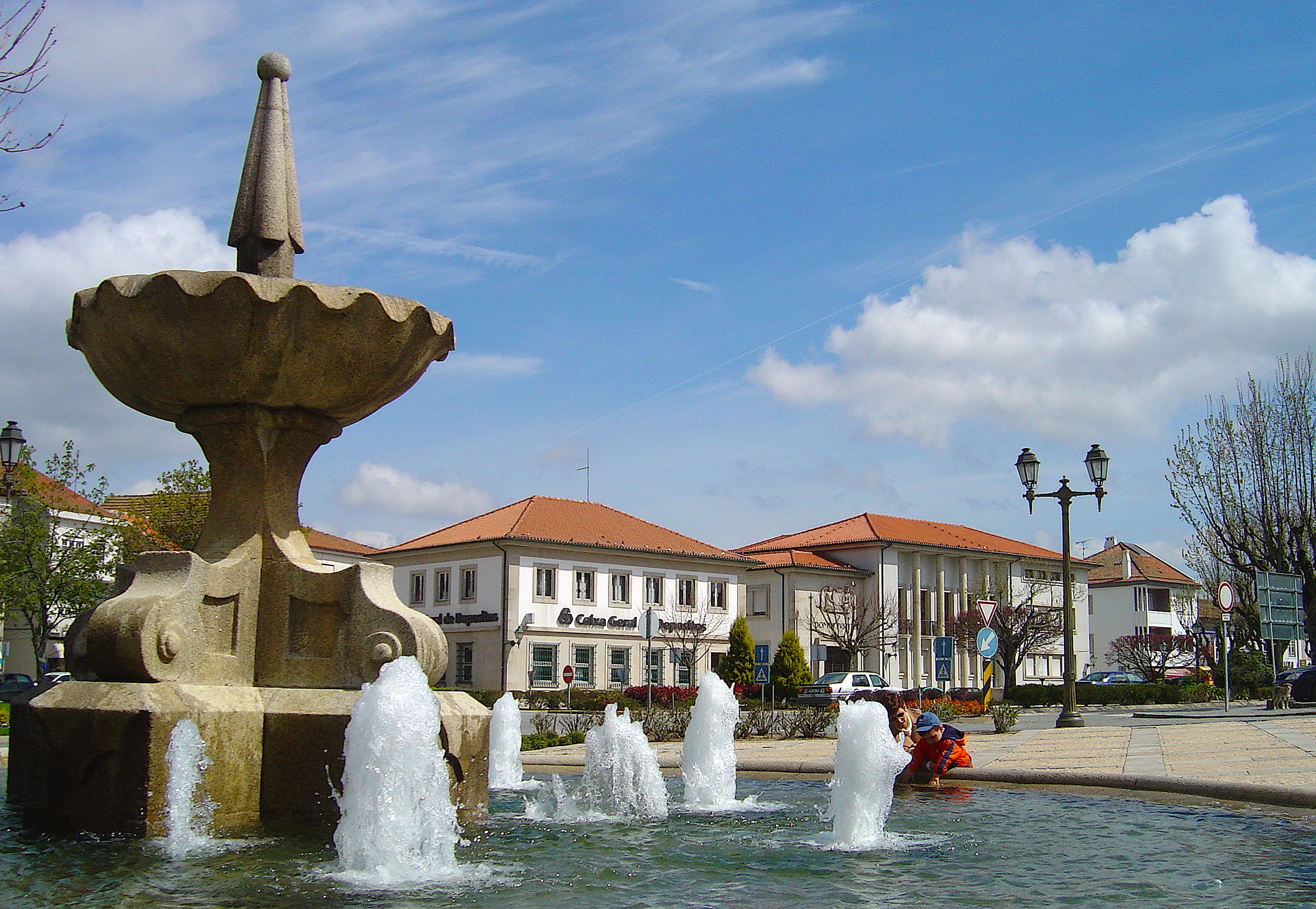
Mangualde Municipality (Concelho) 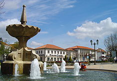 The main square in Mangualde, Largo Dr. Couto, location of the municipal authority
 Flag
Flag Coat of arms
Official name: Concelho de Mangualde Country  Portugal
Region Centro Subregion Dão-Lafões District Viseu Municipality Mangualde Civil Parishes Abrunhosa-a-Velha, Alcafache, Chãs de Tavares, Cunha Alta, Cunha Baixa, Espinho, Fornos de Maceira Dão, Freixiosa, Lobelhe do Mato, Mangualde, Mesquitela, Moimenta de Maceira Dão, Póvoa de Cervães, Quintela de Azurara, Santiago de Cassurrães, São João da Fresta, Travanca de Tavares, Várzea de Tavares Rivers Dão, Mondego Center Mesquitela - elevation 544 m (1,785 ft) - coordinates 40°35′19.43″N 7°43′45.59″W / 40.5887306°N 7.7293306°W Length 28.75 km (18 mi), Southwest-Northeast Width 13.77 km (9 mi), Southeast-Northwest Area 219.25 km2 (85 sq mi) Population 19,879  (2011)
Density 90.67 / km2 (235 / sq mi) Settlement 5th century - Municipality c. 1102 LAU Concelho/Câmara Municipal - location Largo Dr. Couto, Mangualde, Mangualde - elevation 525 m (1,722 ft) - coordinates 40°36′15.06″N 7°45′40.34″W / 40.6041833°N 7.7612056°W President João Nuno Ferreira Gonçalves Azevedo (PS) Municipal Chair Leonor Maria Gonçalves Pacheco Pais Andrade Cardoso (PS) Timezone WET (UTC0) - summer (DST) WEST (UTC+1) ISO 3166-2 code PT- Postal Zone 3534-004 Mangualde Area Code & Prefix (+351) 232 XX XX XX Demonym Mangualdense Municipal Address Câmara Municipal de Mangualde, Largo Dr. Couto
3534-004 MangualdeMunicipal Holidays 8 September Wikimedia Commons: Mangualde Statistics: Instituto Nacional de Estatística[1] Website: http://www.cmmangualde.pt Geographic detail from CAOP (2010)[2] produced by Instituto Geográfico Português (IGP) Mangualde (Portuguese pronunciation: [mɐ̃ˈɡwaɫd(ɨ)]) is a municipality in the subregion of Dão-Lafões (historical Beira Interior), central region of Portugal, with a total area of 219.25 km² and a total population of 19,879 inhabitants (2011).
Contents
History
The region of Mangualde has been a crossroads of many peoples: Viriathus's warriors, transhumance shepards, Romans, Moors and Christian conquerors, including soldiers from Castile or France, or even pilgrims.[3] Mangualde was an important outpost in the textile trade from Covilhã, Seia and Gouveia.[3] Its location, on the frontier with the Serra da Estrela and marginalized by its geography to north, was nonetheless a channel of pre-historic cultures associated with the dolmens that are found through the region. The mount of Nossa Senhora do Castelo, is one such example of the pre-Romanic castros that were used by the early settlers, then reappropriated by the Roman soldiers as forts.[3]
The Romans, attracted by the riches of the Iberian Peninsula (primarily minerals), began to progressively occupy the region until the 5th century, when barbarians invaded the peninsula. Romanization of these lands resulted in a diffusion and assimilation of cultural structures, political hierarchies, social institutions, the economy and religious services.[3] Mangualde was one of the principal access-ways in Lusitânia, connecting Emerita Augusta (Mérida) to Bracara Augusta (Braga).[3] Along the roadway, millennium or road markers were discovered in Abrunhosa-a-Velha, noting the repairs completed to the road under emperors Hadrian and Numerian. Similarly, a second via crossed the Alcafache bridge (a Roman-built structure) towards Espinho, while another crossed the rivers from the north.[3]
After the barbarian invasions, the region was also taken by Muslim forces, who occupied the area of Nossa Senhora do Castelo. This place became known by the military governor, Zurara, and the fort constructed on the site referred to asCastelo de Zurara (or also Castelo de Azurara), overtime becoming transliterated in ancient name of the municipality: Azurara da Beira.[3] In 1058, the medieval castle was conquered from the Moors, by the forces of Ferdinand I of León and Castile.[3] By 1102, Count Henrique and Countess Theresa, before the independence of Portugal, issued a foral to the lands of Zurara, between the Dão and Mondego Rivers. It was later confirmed by Afonso II, when the monarch issued his ordinances in February 1217, and by King Manuel in 1514, during his reforms.[3] When Christian forces finally took the fortress, they discovered a privileged lookout that provided line-of-sight for thousands of miles.[3]
During the Middle Ages, the town of Mangualde grew from two distinct poles: the first was designated Cabo da Vila and the other Rossio.[3]
With time, even the population of Rossio began to develop into another distinct neighborhood. Around this time (the middle of the 17th century) the new space was nothing more then some modest dwellings occupied by locals.
After the 17th century, with the creation of the Misericórdia by Philip II, the institution of "outside" judges by King John IV (1655), Mangualde experienced a period of great expansion.[3]
In the 19th century, residential growth was significant, helped on by the construction of a new highway towards Guarda, which contributed to this development.[3] Overtime the two original poles merged (in the 20th century), and Rossio took on a greater role: many of the social and economic functions of Mangualde concentrated in Rossio, including public services, banking, commercial shops and cafes.[3]
On 3 July 1986, the Portuguese Assembly ratified the elevation of the town to the category of city.[3]
Geography
Mangualde is dominated by a plateau/table sloping to the south, cut by tributaries of the Dão and Mondego Rivers: the municipality is crossed in the north by the Dão River defining its northern frontier, while its southern border is limited by the Mondego. In addition to these rivers, Mangualde is crossed by a series of gently-flowing ravines and rivers, such as the Ribeira de Frades, Ribeira do Castelo and the Ribeira de Videira, in the western extend of the municipality.[3] The Fagilde reservoir is the largest extension of these limits, and supports the community to the north of Mangualde.
Along the valleys there are many fertile alluvial lands, of which, the more fertile parcels are located in the central part of the municipality, around the civil parishes of Mangualde, Fornos de Maceira Dão, Espinho and Alcafache.[3]
Geomorphologically, Mangualde is part of the Maciço Antigo (Old Massif), dating to the Paleozoic. It was affected by a period of prolonged erosion, that was later rejuvenated by upheaval associated with mountain-building. Most of the area is composed of granite, and mitigated by mountain hydrology.[3] A small group of mountains along the east, the Serra do Bom Successo, witih extend to Guimarães de Tavares. In addition, other mountainous areas include the Serras de Abrunhosa-a-Velha, Cunha Alta and Almeidinha which link to the Serra da Senhora do Castelo. Disperse and running along lower elevations, the topography is highlighted by the higher elevations in Tabosa, Roda an Fagilde.[3]
Climate
The climate is Mediterranean, influenced by continental systems, resulting in cold winters and warm, dry summers.[3]
Human geography
Population of the
municipality of Mangualde
(1801 - 2004)Year Pop. ±% 1801 10,216 — 1849 12,345 +20.8% 1900 22,340 +81.0% 1930 23,225 +4.0% 1960 23,311 +0.4% 1981 21,438 −8.0% 1991 21,808 +1.7% 2001 20,990 −3.8% 2004 21,158 +0.8% 2011 19,879 −6.0% Located 15 kilometres from the district seat of Viseu, the municipality of Mangualde is surrounded by Penalva do Castelo (to the north), Viseu (to the west), Nelas, Seia and Gouveia (to the south) and Fornos de Algodres (to the east).[3]
Its area includes 18 civil parishes, including:
- Abrunhosa-a-Velha
- Alcafache
- Chãs de Tavares
- Cunha Alta
- Cunha Baixa
- Espinho
- Fornos de Maceira Dão
- Freixiosa
- Lobelhe do Mato
- Mangualde
- Mesquitela
- Moimenta de Maceira Dão
- Póvoa de Cervães
- Quintela de Azurara
- Santiago de Cassurrães
- São João da Fresta
- Travanca de Tavares
- Várzea de Tavares
Economy
The Portuguese branch of PSA Group, Peugeot Citroen Automóveis Portugal S.A, has its industrial facilities in Mangualde.
Architecture
Archaeology
- Castro of Bom Sucesso (Portuguese: Castro do Bom Sucesso)
- Dolmen of Cunha Baixa (Portuguese: Anta de Cunha Baixa)
Civic
- Citânia de Raposeira
- Fountain of Ricardina (Portuguese: Fonte de Ricardina)
- Palace of the Counts of Anadia (Portuguese: Palácio dos Condes de Anadia)
- Pillory of Abrunhosa-a-Velha (Portuguese: Pelourinho de Abrunhosa-a-Velha)
- Pillory of Chãs de Tavares (Portuguese: Pelourinho de Chãs de Tavares)
- Old Clock-tower (Portuguese: Torre do Relógio Velho)
Religious
- Chapel of Nossa Senhora de Cervães (Portuguese: Capela de Nossa Senhora de Cervães)
- Church of São Julião (Portuguese: Igreja Matriz de São Julião)
- Church of the Misericórdia (Portuguese: Igreja da Misericórdia de Mangualde)
- Hermitage of Nossa Senhora do Castelo (Portuguese: Ermida de Nossa Senhora do Castelo)
- Monastery of Santa Maria de Maceira Dão (Portuguese: Real Mosteiro de Santa Maria de Maceira Dão)
References
- Notes
- ^ INE, ed. (2010) (in Portuguese), Censos 2011 - Resultadas Preliminares [2011 Census - Preliminary Results], Lisbon, Portugal: Instituto Nacional de Estatística, http://www.ine.pt/xportal/xmain?xpid=INE&xpgid=ine_publicacoes&PUBLICACOESpub_boui=122114780&PUBLICACOESmodo=2, retrieved 1 July 2011
- ^ IGP, ed. (2010) (in Portuguese), Carta Administrativa Oficial de Portugal, Lisbon, Portugal: Instituto Geográfico Português, http://www.igeo.pt/produtos/cadastro/caop/download/Areas_Freg_Mun_Dist_CAOP2010.zip, retrieved 1 July 2011
- ^ a b c d e f g h i j k l m n o p q r s t u Câmara Municipal de Mangualde, ed. (2011) (in Portuguese), História de Mangualde, Mangualde, Portugal, http://www.cmmangualde.pt/index.php?option=com_content&view=article&id=90&Itemid=80, retrieved 26 September 2011
External links
Abrunhosa-a-Velha · Alcafache · Chãs de Tavares · Cunha Alta · Cunha Baixa · Espinho · Fornos de Maceira Dão · Freixiosa · Lobelhe do Mato · Mangualde · Mesquitela · Moimenta de Maceira Dão · Póvoa de Cervães · Quintela de Azurara · Santiago de Cassurrães · São João da Fresta · Travanca de Tavares · Várzea de TavaresHeritage sites Other buildings and structures Nossa Senhora do Castelo Chapel
Armamar · Carregal do Sal · Castro Daire · Cinfães · Lamego · Mangualde · Moimenta da Beira · Mortágua · Nelas · Oliveira de Frades · Penalva do Castelo · Penedono · Resende · Santa Comba Dão · São João da Pesqueira · São Pedro do Sul · Sátão · Sernancelhe · Tabuaço · Tarouca · Tondela · Vila Nova de Paiva · Viseu · Vouzela Categories:
Wikimedia Foundation. 2010.