- Mandurah railway line
-
Mandurah Railway Line Legend

to Clarkson line 


0.0 km Perth Underground 

0.6 km Esplanade 


Mitchell Freeway (southbound) 
Riverside Drive 
Swan River (Narrows Bridge) Mill Point Road 
Mill Point Road onramp (northbound) 

7.3 km Canning Bridge Canning Highway Manning Road Gentilli Way Bridge Canning River (Mount Henry Bridge) The Esplanade Cranford Avenue Leach Highway 11.7 km Bull Creek Parry Avenue South Street 13.8 km Murdoch Farrington Road Roe Highway 
Thornlie Spur 

Forrestfield Freight Line 


Berrigan Drive 20.5 km Cockburn Central Armadale Road 

Cockburn Siding 
Russell Road Rowley Road Anketell Road Kwinana Freeway Tunnel Thomas Road 32.9 km Kwinana Sulphur Road Challenger Avenue Wellard Road 37.3 km Wellard Kwinana Freight Line Mandurah Road 43.2 km Rockingham Elanora Drive Safety Bay Road 47.6 km Warnbro Stake Hill Road Paganoni Road Mandjoogoordap Drive Gordon Road Fremantle Road 

Mandurah Rail Depot 
70.1 km Mandurah Transperth Railway Lines Armadale / Thornlie Fremantle Joondalup Mandurah Midland List of Transperth stations The Mandurah Railway Line is a suburban railway line, running through the south western suburbs of Perth, Western Australia. Partly located in the median of the Kwinana Freeway, the line connects Perth with Western Australia's second largest city, Mandurah. The line opened on 23 December 2007.[1]
Contents
History
Legislation for the construction of the Mandurah Line was passed in December 1999.[2] The original proposed route branched from the Armadale Line at Kenwick, and then ran alongside the freight lines until Jandakot where it would run in the middle of the Kwinana Freeway. However, a bill passed in November 2002 after a change of state government saw that the route would start at Perth, traverse the Kwinana Freeway, and then continue along its initial route after Jandakot.[3] This second route was much more direct, and allowed through services with the Joondalup Line. However, the second direct route was more costly than the original indirect route. This decision also led to the relocation of the Rockingham Train Station from the city centre to the outer edge in order to offset the additional costs of the Perth section. The original route included tunnels to bring the railway into the Rockingham CBD. As a trade off for relocating the Rockingham Station to the outer edge, the State Government promised a light rail link to the Rockingham CBD. This was later revised to a Central Area Transit (CAT)-style bus service partly within a dedicated busway.
Construction of the line started in February 2004. The contract for the city centre works, including the tunnels, was awarded to a joint venture of Leighton Contractors and Kumagai Gumi. The contractors used a Tunnel Boring Machine manufactured by Mitsubishi Heavy Industries.[4] The first tunnel was completed on 3 June 2006,[5] and the second tunnel was completed on 27 October 2006.[6]
Between 2004 and 2006, the Leighton Kumagai Joint Venture (LKJV) was affected by a series of industrial disputes involving the Construction Forestry Mining and Energy Union. This culminated in the prosecution of 107 workers for taking illegal industrial action, by the Australian Building and Construction Commission. Prosecution of "the Perth 107" became a national and international cause celebre, in part because it occurred as the Federal Government's industrial relations policy WorkChoices was taking place.
The line was proposed to be opened on 29 July 2007,[7] but was not complete by that date.
From 7 October 2007 to 14 October a planned shutdown of the whole Fremantle Line and partial closure of the Clarkson Line between Perth and Leederville stations was undertaken to allow workers to connect the Mandurah Line to the Clarkson Line. On 8 October there was considerable publicity about delays experienced by commuters. This was mainly due to signalling problems associated with works for the shutdown week.[8] As a result of the problems on 8 October and 9 October passengers on the Clarkson line were given free travel from first service until 8:00am.[9] On 15 October the Perth Underground and Esplanade stations were opened. On this day, the railway also carried its first passengers with the extension of Clarkson Line services to Esplanade station.[10]
On 9 November 2007, the first train crossed Narrows Bridge to Rockingham station, testing the new railway line at around 7:30am with a driver and a group of engineers. After the line testing completed, driver training was undertaken.[1]
The line was officially opened on 23 December 2007, with the first train carrying 1500 passengers, including 1000 members of the public selected by ballot.[11] To celebrate, all Transperth bus, train and ferry services were free. On 24 December 2007, new routes and schedules took effect on many services, including the Mandurah Line.[12]
The line replaced bus services which previously travelled along the freeway to the city, which now terminate at Mandurah Line stations. The exception is Canning Highway services, which stop at Canning Bridge station before continuing to the city.[13]
Train stations
- For the station name:
- Red denotes Perth CBD stations.
- Orange denotes Mandurah line stations.
- Black denotes terminuses.
- For the zones, see Transperth fare zone. FTZ stands for Free Transit Zone.
- For the patterns, see next section.
- The section between the Perth underground and Esplanade stations is considered to be part of both the Joondalup and Mandurah Lines.
- Special event services (such as AFL football games) terminate at West Leederville station on the Fremantle Line. These services skip Esplanade and Perth on the Mandurah Line as well as City West on the Fremantle Line.
Name of Station Code Zones Serving Suburbs Pattern stops at this station Transfers Mandurah Line Perth Underground MPH 1, FTZ Perth, Northbridge All C K W Through to Clarkson Line
Platform transfer to Armadale / Thornlie Line, Fremantle Line, Midland Line, and the Transwa Australind service to Bunbury
Bus transfers at Wellington Street bus stationEsplanade REE 1, FTZ Perth All C K W Through to Clarkson Line
Bus transfers at Esplanade BusportCanning Bridge RCE 1 Applecross, Como All K W Bus transfers Bull Creek RBK 2 Bateman, Brentwood, Bull Creek All C K W Bus transfers Murdoch RMU 2 Bateman, Bull Creek, Murdoch, Leeming All C K W Bus transfers (including CircleRoute), TransWA coach services Cockburn Central RCL 3 Jandakot, Atwell, Success, Cockburn Central All C K W Bus transfers Kwinana RKA 4 Bertram, Orelia, Parmelia, The Spectacles All C KU Bus transfers Wellard RWD 4 Leda, Wellard All C KU Bus transfers Rockingham RRM 5 Cooloongup, Hillman, Rockingham All C K Bus transfers Warnbro RWO 5 Warnbro, Waikiki All C Bus transfers Mandurah RMH 7 Greenfields, Mandurah All C Bus transfers, TransWA coach services 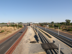 The Mandurah Line south of Cockburn Central station, facing north.
Stopping patterns
- All - all stops to Mandurah.
- C - does not stop at Canning Bridge.
- K - (to Rockingham) all stops to Cockburn Central, then express to Rockingham.
- K - (to Perth) departs from Rockingham, all stops to Perth.
- M - special event services (generally AFL games) between Mandurah/Cockburn Central and West Leederville. Does not stop at Esplanade, Perth or City West stations.
- W - all stops to/and terminates at Cockburn Central. Some services with this pattern use 4 car sets of the Transperth A-series train. The service is then reversed and runs from Cockburn Central to Perth, stopping at all stations.
See also
- New MetroRail
- Transperth
- Transperth Trains
- List of Perth railway stations
- Doncaster railway line - a similar line proposed in 1890 in Melbourne, began construction in 1970s and aborted despite massive requirement.
References
- ^ a b Pemble, Louise (9 November 2007). "Perth to Mandurah railway line open soon". The Sunday Times. http://www.news.com.au/perthnow/story/0,21598,22736361-2761,00.html.
- ^ "PTA History at a Glance, 1976 to 2000". http://www.pta.wa.gov.au/scripts/viewarticle.asp?NID=1823.
- ^ "PTA History at a Glance, 2001 to Present". http://www.pta.wa.gov.au/scripts/viewarticle.asp?NID=1824.
- ^ Brochure - Tunnel Boring Machine
- ^ "First of twin rail tunnels completed". http://www.pta.wa.gov.au/scripts/viewarticle.asp?NID=2127.
- ^ "Final breakthrough of CBD tunnel achieves engineering feat". http://www.mediastatements.wa.gov.au/media/media.nsf/news/63ECA7DA2A95051C48257214000FFAC4?opendocument.
- ^ "New MetroRail: Southern Suburbs Railway". http://www.newmetrorail.wa.gov.au/Default.aspx?tabid=77.
- ^ "Free travel on Clarkson line as chaos hits Perth". http://www.news.com.au/perthnow/story/0,21598,22548833-2761,00.html.[dead link]
- ^ "Important information for Clarkson Line passengers". http://www.transperth.wa.gov.au/ServiceInfo/ServiceDisruptions/tabid/128/newsid563/334/Default.aspx.
- ^ Public Transport Authority (2007-10-14). "Perth’s new underground railway stations ready for action". http://www.pta.wa.gov.au/scripts/viewarticle.asp?NID=2422. Retrieved 2008-01-13.[dead link]
- ^ "1500 people take the first Perth to Mandurah train journey". Archived from the original on 2007-12-24. http://web.archive.org/web/20071224173908/http://www.thewest.com.au/default.aspx?MenuID=77&ContentID=52023. Retrieved 2007-12-23.
- ^ "DESTINATION MANDURAH". http://www.transperth.wa.gov.au/DestinationMandurah/tabid/300/Default.aspx. Retrieved 2007-12-12.
- ^ "Destination: Canning Bridge, Bull Creek and Murdoch". http://www.transperth.wa.gov.au/DestinationMandurah/Stationinformation/CanningBridgeBullCreekMurdoch/tabid/303/Default.aspx. Retrieved 2007-12-16.
Categories:- Railway lines in Perth, Western Australia
- Mandurah
- For the station name:

Wikimedia Foundation. 2010.