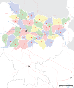
- Majorganj (community development block)
-
Majorganj — community development block — Coordinates 26°43′47″N 85°29′16″E / 26.7296110°N 85.4878120°ECoordinates: 26°43′47″N 85°29′16″E / 26.7296110°N 85.4878120°E Country India State Bihar District(s) Sitamarhi Parliamentary constituency Sitamarhi Assembly constituency Bathnaha Population 80,195 (2001[update]) Time zone IST (UTC+05:30) Majorganj (community development block) (Hindi: मजोरगंज सामुदायिक विकास खंड) is an administrative division in Sitamarhi district in the Indian state of Bihar.
Contents
Geography
Majorganj is located at 26°43′47″N 85°29′16″E / 26.7296110°N 85.4878120°E
Panchayats
Panchayats in Majorganj community development block are: Ratanpur, Basbitta, Pachharwa, Bahera, Kuari Madan, Mejorganj, Khairwa and Dumri Kala.[1]
Demographics
As per 2001 census, Majoganj block had a population of 80,195.[2]
See also
References
- ^ "Majorganj". Blocks of Sitamarhi. brandbihar.com. http://www.brandbihar.com/english/districts%5Csitamarhi%5CSitamarhi_MAJORGANJ.html. Retrieved 2011-02-07.
- ^ "Republic of India, Bihar". Geo Hive. http://www.xist.org/cntry/in-10.aspx. Retrieved 2011-02-07.
Tirhut division topics General Districts Community development blocks Goraul • Majorganj • Raghopur • SahebganjRivers Transport Lok Sabha constituencies Hajipur • Muzaffarpur • Paschim Champaran • Purvi Champaran • Sheohar • Sitamarhi • Vaishali • Valmiki NagarFormer Lok Sabha constituencies Vidhan Sabha constituencies West Champaran Valmiki Nagar • Ramnagar • Narkatiaganj • Bagaha • Lauriya • Nautan • Chanpatia • Bettiah • Sikta East Champaran Raxaul • Sugauli • Narkatiya • Harsidhi • Govindganj • Kesaria • Kalyanpur • Pipra • Madhuban • Motihari • Chiraia • Dhaka Sheohar Sheohar Sitamarhi Riga • Bathnala • Parihar • Sursand • Bajpatti • Sitamarhi • Runnisaidpur • Belsand Muzaffarpur Gaighat • Aurai • Minapur • Bochahan • Sakra • Kurhani • Muzaffarpur • Kanti • Baruraj • Paroo • Sahebganj Vaishali Hajipur • Lalganj • Vaishali • Mahua • Raja Pakar • Raghopur • Mahnar • PatepurFormer Vidhan Sabha constituencies See also Cities and towns in Tirhut Division • Villages in West Champaran district • Villages in East Champaran district • Villages in Sitamarhi district • Villages in Muzaffarpur district • Villages in Vaishali district • People from Sitamarhi district • Bihar topicsOther Divisions Bhagalpur • Darbhanga • Kosi • Magadh • Munger • Patna • Purnia • SaranCategories:- Community development blocks in Sitamarhi district
Wikimedia Foundation. 2010.


