- North Aral Sea
-
North Aral Sea 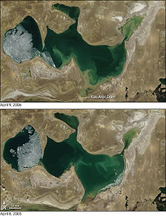
Location  Kazakhstan,
Central AsiaCoordinates 46°30′N 60°42′E / 46.5°N 60.7°ECoordinates: 46°30′N 60°42′E / 46.5°N 60.7°E Lake type endorheic, natural lake, reservoir Primary inflows Syr Darya
(previously also the Amu Darya)Basin countries Kazakhstan Surface area 3,300 km2 (1,270 sq mi) (2008)
3,105 km2 (1,199 sq mi) (2007)
2,550 km2 (985 sq mi) (2003)Average depth 8.7 m (29 ft) (2007) Max. depth 30 m (98 ft) (2003)
18 m (59 ft) (2007)
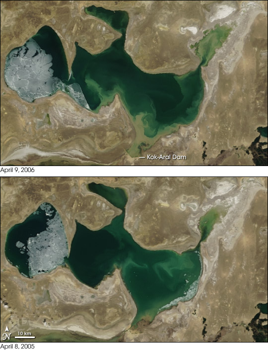
42 m (138 ft) (2008)Water volume 27 km3 (6 cu mi) (2007) Surface elevation 42 m (138 ft) (2007) The North Aral Sea is the portion of the former Aral Sea that is fed by the Syr Darya River. It split from the South Aral Sea in 1986 as water levels dropped due to river diversion for agriculture. The poorly built Dike Kokaral intended to contain the North Aral Sea and save its fisheries failed twice, but in 2005 the government of Kazakhstan was able to fund a more robust design. Since then, water levels have risen faster than expected and fish stocks have increased. Plans to build a second dike to increase water levels further are due to begin in 2010.
Contents
Background
The Aral Sea began shrinking in the 1960s, when the Soviet Union decided that the two rivers feeding it, the Amu Darya and the Syr Darya, would be diverted to irrigate cotton and food crops in Kazakhstan and Uzbekistan. In 1986, due to an accelerated loss of water, the Aral Sea was split into northern and southern parts; the southern part is the current South Aral Sea.
Salinity
There is now an ongoing effort in Kazakhstan to save and replenish the North Aral Sea. As part of this effort, a dam project was completed in 2005; in 2008, the water level in this lake had risen by 22 m (72 ft) from its level in 2007. Salinity has dropped, and fish are again found in sufficient numbers for some fishing to be viable.
Current situation
After the fall of the Soviet Union, the government of independent Kazakhstan decided to restore the northern lake fed by Syr Darya. In 2003, the lake was 30 m (98 ft) in depth and 2,550 km2 (985 sq mi) in area[1] (JAXA source: 3,200 km2 (1,240 sq mi));[2] by 2008 it had reached 42 m (138 ft) in depth and 3,300 km2 (1,270 sq mi) in area[1][3] (JAXA source: 3,600 km2 (1,390 sq mi)).[2]
References
Lakes of KazakhstanCategories:- Landforms of Kazakhstan
- Aral Sea
Wikimedia Foundation. 2010.