- Desouk
-
Coordinates: 31°8′32″N 30°38′42″E / 31.14222°N 30.645°E
Desouk
دسوق (Arabic)
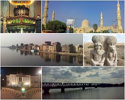
DosūqSt. Ibrahim El-Desouki Tomb · St. Ibrahim El-Desouki Mosque.
Neighborhood of south Desouk · A statue of Ramesses II with Goddess Sekhmet.
Presidency of Desouk City · Desouk old bridge (1897).
Flag
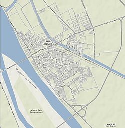
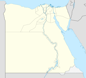
SealNickname(s): Bride of the Nile Desouk City Map Location in Egypt Coordinates: 31°8′32″N 30°38′42″E / 31.14222°N 30.645°E Country  Egypt
EgyptGovernorate Kafr el-Sheikh Government – Type Markaz – President Mahmoud Zaghloul (Acting President)[1] Population (2009) – Total 129,604 Time zone EST (UTC+2) ZIP code 33611 – 33612[2][3] Area code(s) +2 047 Website Presidency of Desouk City Desouk (Arabic: دسوق, Transliterated: Dosūq) is a city in northern Egypt. Located 80 km east of Alexandria, it belongs to Kafr el-Sheikh Governorate and had a population of 129,604 inhabitants as of 2009.[4]
Contents
Overview
Desouk is a member of the Organization of Islamic Capitals and Cities,[5] because there are important Islamic shrines in the city, like The tomb of Saint "Ibrahim El-Desouki" (13th century) is located in the great mosque in the centre of Desouk. His descendants live in Desouk, Alexandria, Cairo, and many live in the UK and USA.[citation needed]
Desouk was the capital of Lower Egypt kingdom before the unification of north and south.[6] and was the capital of Egypt 6 times before 3200 BC, It was called Buto.[7]
Desouk lies on the Nile, on the eastern banks of the Rosetta branch, where there are only two bridges to enter the city.
Many important Egyptians hail from Desouk: Youssef El-Mansy, Ahmed Zewail,[8] Mohammed Roshdy, Evelyn Ashamallah, and Abdel-Salam Mohammed Nasar, a famous politician in the city.
See also
References
- ^ "مخالفات مهولة لرئيس مدينة دسوق المخلوع (Arabic)". alwafd.org. http://www.alwafd.org/index.php?option=com_content&view=article&id=19634. Retrieved 2011-02-27.
- ^ "ZIP code, Desouk (1)". Epcodes.com. http://www.epcodes.com/1057.htm. Retrieved 2010-12-28.
- ^ "ZIP code, Desouk (2)". Epcodes.com. http://www.epcodes.com/1090.htm. Retrieved 2010-12-28.
- ^ "Presidency of Desouk City, Administrative division & Population (2009)". Epcodes.com. 2009-12-31. http://desouq.org/ta2sim-edari.html. Retrieved 2010-12-29.
- ^ "Organization of Islamic Capitals and Cities, Membership". http://www.oicc.org. http://www.oicc.org/oiccenglish/membership.htm. Retrieved 2010-12-29.
- ^ "ANCIENT EGYPT, The Predynastic Period and the First and Second Dynasties, 6000-2686 B.C.". Countrystudies.us. http://countrystudies.us/egypt/5.htm. Retrieved 2010-12-28.
- ^ "The Old Kingdom, Middle Kingdom, and Second Intermediate Period, 2686 to 1552 B.C.". Countrystudies.us. http://countrystudies.us/egypt/6.htm. Retrieved 2010-12-28.
- ^ "Egyptian figures, Ahmed H. Zewail". sis.gov.eg. http://www.sis.gov.eg/VR/figures/english/html/a1.htm. Retrieved 2010-12-28.
External links
- The official site of Presidency of Desouk City (Arabic)
- The official site of Kafr el-Sheikh Governorate (Arabic, English)
 Main Egyptian cities6th of October City · Akhmim · El Alamein · Abydos · Alexandria · Arish · Aswan · Asyut · Banha · Bani Suwayf · Cairo · Dahab · Dakhla · Damanhur · Damietta · Dandarah · Desouk · Esna · Faiyum · Hurghada · Hamrah Dawm · Hala'ib · Imbabah · Ismailia · Giza · Kafr el-Dawwar · Kom Ombo · Kharga · Luxor · El-Mahalla El-Kubra · Mallawi · Mansoura · Marsa Matruh · el-Menya · Nag Hammadi · Nuweiba · Noubarya · Port Said · Qena · Rosetta · Sadat City · Safaga · Saint Katherine · Siwa · Sharm el-Sheikh · Shibin El Kom · Shibin el-Qanater · Shubra el-Kheima · Sohag · Ain Sukhna · Suez · Taba · Tanta · Zaqaziq ·
Categories:- Kafr el-Sheik Governorate
- Populated places in Egypt
- Cities in Ancient Egypt
- Ancient Greek sites in Egypt
- Egypt geography stubs
Wikimedia Foundation. 2010.


