- Rosetta
Infobox Settlement
official_name = Rosetta
other_name =Rashid
native_name = رشيد
nickname =
settlement_type =
motto =
imagesize =
image_caption = Nineteenth-centurycannon s in a mid-town square in Rosetta
flag_size =
image_
seal_size =
image_shield =
shield_size =
city_logo =
citylogo_size =
mapsize =
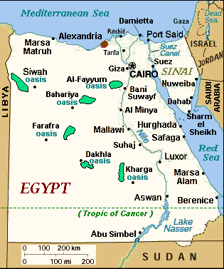
map_caption =Egypt : Site of Rashid (top center)
mapsize1 =
map_caption1 =
image_dot_
dot_mapsize =
dot_map_caption =
dot_x = |dot_y =
pushpin_
pushpin_label_position =
pushpin_map_caption =
pushpin_mapsize =
subdivision_type = Country
subdivision_name =Egypt
subdivision_type1 = governorate
subdivision_name1 = al-Buhayrah
subdivision_type2 =
subdivision_name2 =
subdivision_type3 =
subdivision_name3 =
subdivision_type4 =
subdivision_name4 =
government_footnotes =
government_type =
leader_title =
leader_name =
leader_title1 =
leader_name1 =
leader_title2 =
leader_name2 =
leader_title3 =
leader_name3 =
leader_title4 =
leader_name4 =
established_title = Founded
established_date = AD 800
established_title2 =
established_date2 =
established_title3 =
established_date3 =
area_magnitude =
unit_pref = Imperial
area_footnotes =
area_total_km2 =
area_land_km2 =
area_water_km2 =
area_total_sq_mi =
area_land_sq_mi =
area_water_sq_mi =
area_water_percent =
area_urban_km2 =
area_urban_sq_mi =
area_metro_km2 =
area_metro_sq_mi =
area_blank1_title =
area_blank1_km2 =
area_blank1_sq_mi =
population_as_of =1996
population_footnotes =
population_note =
population_total =58432
population_density_km2 =
population_density_sq_mi =
population_metro =
population_density_metro_km2 =
population_density_metro_sq_mi =
population_urban =
population_density_urban_km2 =
population_density_urban_sq_mi =
population_blank1_title =
population_blank1 =
population_density_blank1_km2 =
population_density_blank1_sq_mi =
timezone =
utc_offset =
timezone_DST =
utc_offset_DST =
latd=31 |latm=24 |lats= |latNS=N
longd=30 |longm=25 |longs= |longEW=E
elevation_footnotes =
elevation_m =
elevation_ft =
postal_code_type =
postal_code =
area_code =
blank_name =
blank_info =
blank1_name =
blank1_info =
website =
footnotes =Rosetta ( _ar. رشيد Rashid) is a
port city on the Mediterranean coast inEgypt . It is located 65km (40 miles) east ofAlexandria , at coord|31|24|N|30|25|E|, in al-Buhayrah governorate. It was founded around AD 800.With the decline of Alexandria following the Ottoman conquest of Egypt in the 16th century, Rashid boomed, only to wane in importance after Alexandria's revival. During the 19th century it was a popular British tourist destination, known for its charming Ottoman
mansion s,citrus groves and cleanliness.The town of Rashid came to be known in the West as "Rosetta", the name by which it was referred to by the French during
Napoleon Bonaparte 's campaign inEgypt . It is famous as the site where theRosetta Stone was found by French soldiers in 1799.History
It is the modern representative of the ancient
Bolbitine , which lay a little farther north. In theMiddle Ages Rosetta was a place of considerable commercial importance, and it continued to flourish until the construction of theMahmudiyeh Canal and the improvement of the harbour atAlexandria diverted most of its trade to the latter city.It also witnessed the defeat of the 1807 British
Fraser campaign trying to occupy Egypt after the French army left Egypt.Population
The population of Rashid has increased since the 1980s, as follows: in 1983 = 36,711 (approximate), in 1986 = 51,789, and in 1996 = 58,432.
Gallery
References
* "Rosetta," "
Encyclopaedia Britannica ", Chicago, 1983.External links
* Thomas Brinkhoff: City Population, "http://www.citypopulation.de" [http://www.citypopulation.de/Egypt.html "Egypt statistics"]
*
* Detailed map of Egypt (with many ancient temples): [http://unimaps.com/egypt/index.html UniMaps-Egypt] .
Wikimedia Foundation. 2010.
