Depression of Ronda

Depression of Ronda
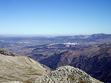
Depression of Ronda seen from the Sierra de Líbar. At center, the city of Ronda and at left, Arriate.
A view from the city of Ronda to the plain below.

The Depression of Ronda (Spanish: Depresión de Ronda; also Hoya de Ronda and occasionally Vega de Ronda) is a sedimentary basin in the form of a plateau located within the Cordillera Penibética, in the autonomous community of Andalusia, Spain. It is one of the series of valleys forming the Surco Intrabético.

The plateau is situated between 700 metres (2,300 ft) and 1,000 metres (3,300 ft) above sea level. Its predominantly composed of sedimentary materials such as sandstones, clays and conglomerates. It is surrounded by various ridges of the Serranía de Ronda and forms a nexus between the valley of the Guadalteba, which opens to the north; the valley of the Guadiaro, to the southwest; and the valley of the Genal, to the southeast. It is flat, but crossed by canyons popularly known as "tajos" ("pits").

The principal rivers are the Guadalevín and the Guadalcobacín, whose confluence forms the Guadiaro.

The predominant climate is Mediterranean with as strong mix of Continental: cold winters and hot summers.

As for flora, Oaks and Cork Oaks dominate, with some presence of Portuguese Oak (Quercus faginea) in wetter areas. On the riverbanks are riparian forests with elms, cottonwoods, poplars and willows. Human activity has thinned the forest, with farmland, olive orchards, pastures, and urbanized areas. Grazing of livestock has degraded oak forest to scrubland with plants such as thyme, rosemary, and esparto.

External links

This article incorporates information from the revision as of 2009-12-23 of the equivalent article on the Spanish Wikipedia.


Wikimedia Foundation. 2010.

Игры ⚽ Поможем написать курсовую

Look at other dictionaries:

  • Surco Intrabético — The valleys that contstitute the Surco Intrabético. The Surco Intrabético (also Depresión Intrabética, Intrabaetic Depression, etc.) is a discontinuous series of valleys in the Baetic Cordillera of Andalusia, Spain, which separate the Cordillera… …   Wikipedia

  • Hoya of Antequera — The Fuente de Piedra Lagoon. The Hoya of Antequera (also Antequera Depression or, in Spanish, Depresión de Antequera, Hoya de Antequera or Vega de Antequera) is a sedimentary basin located in the northern part of the province of Málaga, Andalusia …   Wikipedia

  • Observation deck — The 1793 Puente Nuevo bridge allows viewing from 120 m above the floor of El Tajo canyon. Main article: Deck (building) For other uses, see Deck …   Wikipedia

  • Andalusia — For the more extensive Muslim era region, see Al Andalus. For other uses, see Andalusia (disambiguation). Andalusia Andalucía (Spanish)   Autonomous Community   …   Wikipedia

  • Géographie de l'Andalousie — Située à l extrémité méridionale de la péninsule Ibérique, l Andalousie occupe une superficie de 87 268 km², qui en fait la deuxième communauté autonome espagnole la plus vaste après la Castille et León. Elle s étend sur tout le sud du pays …   Wikipédia en Français

  • Addison Mizner — Born December 12, 1872(1872 12 12) Benicia, California Died February 5, 1933(1933 02 05) …   Wikipedia

  • Effects and aftermath of rape — Physical force is not necessarily used in rape, and physical injuries are not always a consequence. Deaths associated with rape are known to occur, though the prevalence of fatalities varies considerably across the world. For victims the more… …   Wikipedia

  • Spain — /spayn/, n. a kingdom in SW Europe. Including the Balearic and Canary islands, 39,244,195; 194,988 sq. mi. (505,019 sq. km). Cap.: Madrid. Spanish, España. * * * Spain Introduction Spain Background: Spain s powerful world empire of the 16th and… …   Universalium

  • Hurricane Vince (2005) — Infobox Hurricane Name=Hurricane Vince Type=hurricane Year=2005 Basin=Atl Image location=Hurricane Vince eye 2005.jpg Formed=October 8, 2005 Dissipated=October 11, 2005 1 min winds=65 Pressure=988 Da Inflated= Fatalities=None reported… …   Wikipedia

  • Geology of the Iberian Peninsula — The geology of the Iberian Peninsula consists of the study of the rock formations on the Iberian Peninsula, which includes Spain, Portugal, Andorra, and Gibraltar. The peninsula contains rocks from every age from Ediacaran to Recent, and almost… …   Wikipedia

Share the article and excerpts

Direct link
Do a right-click on the link above
and select “Copy Link”