- Surco Intrabético
-
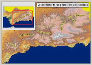
The Surco Intrabético (also Depresión Intrabética, Intrabaetic Depression, etc.) is a discontinuous series of valleys in the Baetic Cordillera of Andalusia, Spain, which separate the Cordillera Penibética to its south from the Cordillera Subbética to its north. These valleys run more or less parallel to the Mediterranean coast. Together, these valleys constitute a route from eastern Andalusia and the valley of the Guadalquivir to the Spanish Levante, the eastern Mediterranean coastal region of Spain. From west to east, the valleys of the Depression of Ronda, the Hoya of Antequera, the Depression of Granada, the Hoya of Guadix, the Hoya of Baza, the Hoya of Huéscar and the Hoya of Lorca.
The valleys of the Surco Intrabético stand in contrast to the adjacent mountain ridges that define their collective border and the rocky spurs—formed of limestone, and yielding a dry, nearly treeless landscape—that separate them from one another in that they are formed of soft materials such as clays, silts and conglomerates, with deep soils suitable for agriculture; the limiting factor to human activity is the scarcity of water.
Literally, Surco Intrabético means "Intrabaetic Groove": that is, a groove within the Baetic Cordillera. This is really a more correct term than Intrabaetic Depression, because much of the Surco Intrabético is at rather high altitudes; hence, it is more of an altiplano than a depression.
The Surco Intrabético formed at the end Oligocene and beginning of the Miocene, as the Baetic ranges were being formed. It is believed that at that time the entire Baetic system was surrounded by water, and the Surco formed a single, continuous valley, sometimes referred to as the Baetic Depression. Later, the spurs crossing the Surco were raised up, turning it into a series of separate valleys.
The valleys of the Surco Intrabético are quite heterogeneous, although all are sedimentary basins. The Depression of Ronda, the westernmost of the valleys, falls fully within the Cordillera Penibética. The Hoya of Antequera is intimately related to the original Baetic Depression: it was a great gulf of the sea that separated the Sierra Morena from the Andalusian ranges. The Depression of Granada is intermediate between the Penibético and Subbético. Finally the Hoyas of Guadix, Baza and Huéscar are more related to the Subbético.
The Surco Intrabético provides a route for Autovía A-92 that connects Seville to Almería, passing through Antequera, Granada, and Guadix. Its branch Autovía A-92N passes through Cúllar and Baza to Puerto Lumbreras, where it meets Autovía A-7, which, in turn continues to Murcia and the Spanish Levante.
References
- This article incorporates information from the revision as of 2009-12-23 of the equivalent article on the Spanish Wikipedia.
- Julián Alonso: Geografía túristica: general y de España, Ed. Centro de Estudios Ramón Areces, Madrid 2006. ISBN 84-8004-637-6.
Categories:- Baetic System
- Valleys of Spain
- Mountains of Andalusia
- Region of Murcia
Wikimedia Foundation. 2010.

