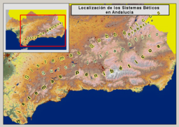
- Cordillera Penibética
-
Cordillera Penibética Sub-Range Country  Spain
SpainState  Andalusia
Part of Baetic System Highest point Mulhacén - elevation 3,479 m (11,414 ft) The Cordillera Penibética mountain range is the most southerly of the Baetic Cordillera; it runs along the south coast of Andalusia, from the province of Cádiz, across the province of Almería, into the Region of Murcia. A little further north, across the intermountain basins known as the Hoya de Baza and the Hoja de Guadix, are the Cordillera Subbética and the Cordillera Prebética.
The Intrabaetic Depression (Spanish: Surco Intrabético), a discontinuous series of valleys, separates the Cordillera Penibética from the Cordillera Subbética in the north.[1]
Contents
Mountain ranges
The main mountain ranges that make up the Penibética complex are, from west to east, the Serranía de Ronda, the Sierra de Grazalema, the Sierra de Tejeda y Almijara, the Sierra Nevada, the Sierra de la Contraviesa, the Sierra de Gádor, the Sierra de Baza, and the Sierra de los Filabres. The following list includes lesser ranges:
- Serranía de Ronda
- Cordillera Antequerana
- Sierra de Tejeda
- Sierra de Almijara
- Sierra Nevada
- Sierra de Lújar
- Sierra de la Contraviesa
- Sierra de Cogollos
- Sierra de Gádor
- Sierra de Baza
- Sierra de los Filabres
- Sierra de Alhamilla
- Sierra Espuña
See also
- Baetic System
- Intrabaetic Depression
References
- ^ Geografía General de España Manuel de Terán y otros. Editorial Ariel ISBN 84-344-3444-X
External links
- A map of the range on Encarta.com
Categories:- Baetic System
- Mountains of Andalusia
Wikimedia Foundation. 2010.

