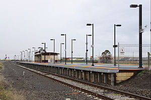
- Deer Park railway station
-
Deer Park 

Station information Code DEK Distance from
Flinders Street20.82 km Operator V/Line Lines Melton,
Ballarat# Platforms 2 # Tracks 2 Status Unmanned Station Metlink profile Link Melway map Link Metcard / Myki Zone 2 Deer Park is a railway station in Melbourne, Victoria, Australia, located in the suburb of Deer Park, on the Ballarat railway line. Deer Park is unmanned and is in Metcard Zone 2.
Deer Park is located at the western end of the Mount Derrimut Road level crossing, which also provides station access. A second pedestrian crossing is located at the Ballarat end of the platform, providing access to the car park. The station consists of two platforms, in an island format, with a small steel shelter in the centre. A small coin-only Metcard ticket vending machine is located inside the shelter, which dispenses only selected ticketing options.
Contents
Platforms and services
Platform 1 and 2:
- Ballarat line - V/Line services to/from Southern Cross, Bacchus Marsh, Ballarat
The tracks between Sunshine and Deer Park are signalled for bidirectional operation, with trains at Deer Park using either platform.
Bus services
- 215 Caroline Springs – Highpoint SC via Albion RS, Burnside SC (every day). Operated by Melbourne Bus Link.
- 216 Caroline Springs – Brighton Beach via Deer Park West, Sunshine, Footscray, Melbourne, St Kilda Road, Prahran (every day). Operated by Melbourne Bus Link.
- 400 Sunshine – Laverton via Ardeer RS, Derrimut, Laverton North (every day). Operated by Westrans & Sita Bus Lines.
- 451 Sunshine – Brimbank Central SC via Ardeer RS, Deer Park (every day). Operated by Sita Bus Lines.
- 456 Sunshine – Woodgrove SC via Albion RS, Burnside SC, Caroline Springs, Melton (every day). Operated by Sita Bus Lines.
History
The station opened as Kororoit on 2 April 1884 at the same time as the line though it, and was renamed Deer Park in 1899, by which time the station had a three road yard, passenger platform on the southern track, and a goods platform on the northern track, and an interlocked signal box. Being on a single track railway, it served as a crossing loop for trains though it, this status remaining until 1913 when the signal box was abolished.[1]
In 1928 a siding serving Nobel Chemical Finishes (Aust) Pty Ltd was opened at the Melbourne end of the station, running north to a loop siding and dead end. In 1929 alterations were made to the electric staff working of trains to permit workers trains to operate to the Nobels factories at Ardeer and Deer Park. In 1943 the signal box was reopened, in conjunction with the opening of the new Ravenhall Siding (Commonwealth Government Siding) at the down end of the yard. This new siding ran south from the line to a loop siding, before terminating at a dead end.[1]
The Nobel siding (now ICIANZ) was closed in 1955, and in 1974 the line from Sunshine to Deer Park West Junction was duplicated, the current island platform provided, and the signal box closed as the line was now being worked by Centralised Traffic Control from Sunshine. Crossovers between lines were provided at each end of the platform. The Ravenhall siding was abolished in 1978. Boom barriers were provided at Mount Derrimut Road in 1981.[1]
In 1987 one of the loop sidings in the yard was removed, with the last siding removed in 1989, leaving only the main line and platform.[1] In 2005, as part of the Regional Fast Rail project, control of the signalling was transferred to Ballarat.[2]
In September 2009 the upgrade of Deer Park station started, including:[3]
- 150 paved car parking spaces
- improved station access, lighting and signage
- improved station security via CCTV
- retain as many trees as possible, as well as planting new trees
- protect native grasses to the east of the new car park
Works were expected to be finished by April 2010, but were still incomplete in May. The works are costed at $5 million.[4]
References
- ^ a b c d "Victorian Station Histories - Deer Park". www.vrhistory.com. http://www.vrhistory.com/Locations/A011-Ardeer.pdf. Retrieved 2008-05-26.
- ^ "VICSIG - Infrastructure - Interlocking - Deer Park". vicsig.net. http://vicsig.net/index.php?page=infrastructure&interlocking=Deer%20Park. Retrieved 2008-05-26.
- ^ "MAJOR IMPROVEMENTS FOR DEER PARK STATION". Media RRelease: Minister for Public Transport. www.premier.vic.gov.au. June 20, 2008. http://www.premier.vic.gov.au/newsroom/2277.html. Retrieved 2010-09-04.
- ^ JANAE HOUGHTON (May 11, 2010). "Long walk to Deer Park station irks users". The Advocate. www.the-advocate.com.au. http://www.the-advocate.com.au/news/local/news/general/long-walk-to-deer-park-station-irks-users/1825487.aspx. Retrieved 2010-06-02.
Station Navigation Metropolitan service Melton line (V/Line service) ← Previous Station Ardeer | Rockbank Next Station → V/Line service Ballarat and Ararat lines ← Previous Station Ardeer | Rockbank Next Station → Entire metropolitan network Entire V/Line network Coordinates: 37°46′40″S 144°46′18″E / 37.7777°S 144.7717°E
Categories:- Railway stations in Melbourne
- Railway stations opened in 1884
Wikimedia Foundation. 2010.
