- Dan Makham Tia District
-
Dan Makham Tia
ด่านมะขามเตี้ย— Amphoe — Amphoe location in Kanchanaburi Province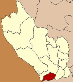
Coordinates: 13°51′13″N 99°24′38″E / 13.85361°N 99.41056°ECoordinates: 13°51′13″N 99°24′38″E / 13.85361°N 99.41056°E Country  Thailand
Province Kanchanaburi Seat Dan Makham Tia Tambon Muban Amphoe established Area - Total 807.1 km2 (311.6 sq mi) Population (2005) - Total 32,248 - Density 40.0/km2 (103.6/sq mi) Time zone THA (UTC+7) Postal code 71260 Geocode 7111 Dan Makham Tia (Thai: ด่านมะขามเตี้ย) is a district (Amphoe) in the southern part of Kanchanaburi Province, central Thailand.
Contents
History
The area of Dan Makham Tia was a village more than 200 years. It was a border village of Mueang Kanchanaburi to Burma.
In the area had a short Makham tree (Tamarindus indica), so people called the village Ban Nong Makham Tia. Later was changed to be Dan Makham Tia.
The minor district (King Amphoe) was created on April 1 1990 by splitting of the three tambon Dan Makham Tia, Klondo and Chorakhe Phueak from Mueang Kanchanaburi district.[1] It was upgraded to a full district on September 8 1995.[2]
Geography
Neighboring districts are (from the north clockwise) Mueang Kanchanaburi, Tha Muang of Kanchanaburi Province, Chom Bueng and Suan Phueng of Ratchaburi Province.
The important water resource is the Khwae Noi and Phachi River.
Administration
The district is subdivided into 4 subdistricts (tambon), which are further subdivided into 39 villages (muban'). Dan Makham Tia is a township (thesaban tambon) which covers parts of the tambon Dan Makham Tia. There are further 4 Tambon administrative organizations (TAO).
No. Name Thai name Villages Inh. 1. Dan Makham Tia ด่านมะขามเตี้ย 12 10,205 2. Klondo กลอนโด 11 8,032 3. Chorakhe Phueak จรเข้เผือก 10 10,158 4. Nong Phai หนองไผ่ 6 3,853 References
- ^ "ประกาศกระทรวงมหาดไทย เรื่อง แบ่งเขตท้องที่อำเภอเมืองกาญจนบุรี จังหวัดกาญจนบุรี ตั้งเป็นกิ่งอำเภอด่านมะขามเตี้ย" (in Thai). Royal Gazette 103 (25 ง): 1347. February 13 1990. http://www.ratchakitcha.soc.go.th/DATA/PDF/2533/D/025/1347.PDF.
- ^ "พระราชกฤษฎีกาตั้งอำเภอด่านมะขามเตี้ย อำเภอแก่งหางแมว อำเภอภักดีชุมพล อำเภอเวียงแก่น อำเภอแม่วาง อำเภอถ้ำพรรณรา อำเภอบ่อเกลือ อำเภอโนนสุวรรณ อำเภอห้วยราช อำเภอแม่ลาน อำเภอบางแก้ว อำเภอป่าพะยอม อำเภอหนองม่วงไข่ อำเภอยางสีสุราช อำเภอจังหาร อำเภอบ้านธิ อำเภอภูสิงห์ อำเภอบางกล่ำ อำเภอวังม่วง และอำเภอนายูง พ.ศ. ๒๕๓๘" (in Thai). Royal Gazette 112 (32 ก): 1–3. August 8 1995. http://www.ratchakitcha.soc.go.th/DATA/PDF/2538/A/032/1.PDF.
External links
Mueang Kanchanaburi · Sai Yok · Bo Phloi · Si Sawat · Tha Maka · Tha Muang · Thong Pha Phum · Sangkhla Buri · Phanom Thuan · Lao Khwan · Dan Makham Tia · Nong Prue · Huai Krachao Categories:
- Amphoe of Kanchanaburi
- Central Thailand geography stubs

Wikimedia Foundation. 2010.